Ground-airborne time-domain electromagnetic data height correction method

A technology of height correction and electromagnetic data, which is applied in the field of airborne geophysical exploration, can solve the problems of height correction and the inability to accurately find the resistivity value, and achieve the effect of simple calculation

Active Publication Date: 2016-04-13
JILIN UNIV
View PDF6 Cites 13 Cited by
  • Summary
  • Abstract
  • Description
  • Claims
  • Application Information

AI Technical Summary

Problems solved by technology

[0005] The above prior art, one discloses the method and interpretation method of electrical source transient electromagnetic ground-air detection, but does not correct the altitude; the other provides an airborne electromagnetic altitude correction method, although a uniform half-space model can be used, etc. However, due to the fact that the actual geological situation is a complex geological structure, the induced electromotive force has a transition process between different media, so it is impossible to accurately find the resistivity when using the uniform half-space model equivalent. value, so the height can only be corrected correctly if the exact conductance value of the subsurface and its depth are known

Method used


Image

  • Ground-airborne time-domain electromagnetic data height correction method
  • Ground-airborne time-domain electromagnetic data height correction method
  • Ground-airborne time-domain electromagnetic data height correction method

Examples


Embodiment

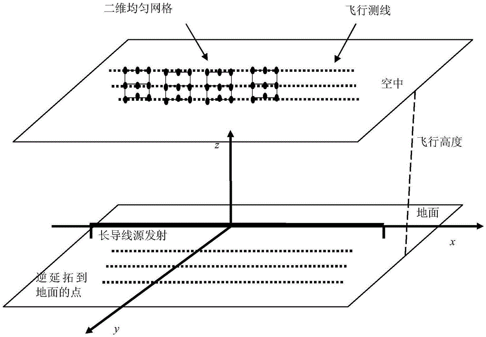
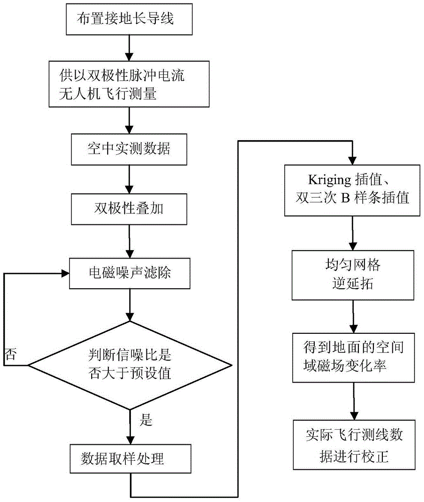
[0067] see figure 2 combine figure 1 As shown, a height correction method for earth-space-time-domain electromagnetic data based on inverse continuation theory, including:

[0068] a. Reasonably arrange the position of the long ground wire, and design at least three flight routes parallel to the long wire in the detection area;

[0069] Such as figure 1 In the step 1 shown, the length of the ground wire source is 1-3 kilometers, and the air flight measurement line needs to be parallel to the ground wire source. -1 times range. Because the magnetic field change rate of each measuring point on the flying survey line needs to be interpolated into the magnetic field change rate of uniform grid points, if the flying survey line spacing is uniform, inter-line interpolation is not required, and the calibration accuracy is higher.

[0070] b. Use a long ground wire as the emission source to supply bipolar pulse current, conduct flight measurement through the receiving system carr...


PUM


Abstract

The invention relates to a ground-airborne time-domain electromagnetic data height correction method. The method mainly comprises the following steps that: an unmanned aerial vehicle or an airship is adopted to perform flight measurement in the air; electromagnetic noise removal and bipolar overlay sampling are performed on measured data; Kriging interpolation and double-cubic B spline interpolation are adopted to perform uniform interpolation on the magnetic field change rate of each measuring point in flight measurement, wherein the magnetic field change rate is expressed by a formula mentioned in the descriptions in the invention, so that magnetic field change rates in two-dimensional uniform grids can be obtained; and an inverse continuation theory is adopted to perform continuation calculation on a magnetic field change rate measured at a height where z=-h in the air, so that the magnetic field change rate data of a site on the ground where z=0 can be obtained, and therefore, flight height correction is realized. With the ground-airborne time-domain electromagnetic data height correction method adopted, the problem of ignoring of height in the prior art in which an LOTEM method is adopted to interpret ground-airborne time-domain electromagnetic data can be solved; the magnetic field change rate data can be directly used to perform correction, and the magnetic field change rate is not required to be converted into a magnetic field to perform correction, and only three flight test lines are just required, so that height correction can be carried out, and a calculation process only involves interpolation and Fourier transform. The ground-airborne time-domain electromagnetic data height correction method has the advantages of simple calculation and high computing speed.

Description

technical field [0001] The invention relates to an airborne geophysical prospecting method in geophysical prospecting, in particular to a height correction method for ground-space-time-domain electromagnetic detection data. Background technique [0002] Ground-airborne Time-domain electromagnetic system (GATEM for short) is to excite the earth with a bipolar pulse current through a long grounded wire to form a large area of ​​electromagnetic waves in space. The system conducts flight surveys to obtain underground magnetic field change rate data. Through resistivity imaging, the existence of underground abnormal geological bodies can be found, and the electrical structure and spatial distribution of abnormal bodies can be determined. The ground-space time-domain electromagnetic detection method not only has the advantages of high detection efficiency of the airborne time-domain electromagnetic method, but also has the advantages of high signal-to-noise ratio and large explora...

Claims


Application Information

Patent Timeline
Patent Type & Authority Applications(China)
IPC IPC(8): G01V3/38
CPCG01V3/38
Inventor 嵇艳鞠吴琼关珊珊黎东升王远林君
Owner JILIN UNIV
Why Eureka
Try Eureka