
Positioning navigation system for underground channel

An underground passage, positioning and navigation technology, which is applied in the field of positioning and navigation systems, can solve the problem that the underground passage cannot be used for positioning and navigation, and achieves the effect of realizing intelligent update, saving time, and saving traffic consumption.

Inactive Publication Date: 2015-08-05
WUXI CITY CHONGAN DISTRICT TECH ENTREPRENEURSHIP SERVICE CENT
View PDF5 Cites 0 Cited by
  • Summary
  • Abstract
  • Description
  • Claims
  • Application Information

AI Technical Summary

Problems solved by technology

[0007] The technical problem to be solved by the present invention is to overcome the deficiencies of the prior art, provide a positioning and navigation system for underground passages, solve the problem that existing underground passages cannot be used for positioning and navigation, realize the positioning and navigation function of underground passages, and facilitate pedestrians use

Method used


Image

  • Positioning navigation system for underground channel

Examples


Embodiment Construction

[0019] Embodiments of the present invention will be described below in conjunction with the accompanying drawings.

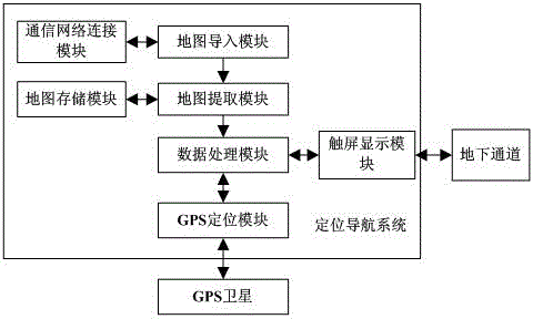
[0020] like figure 1 As shown, the present invention designs a positioning and navigation system for underground passages, including: a communication network connection module, a map import module, a map extraction module, a data processing module, a GPS positioning module, and a touch screen display module, wherein the communication network connection The module is connected to the map import module; the map import module is connected to the map extraction module and the data processing module in turn; the data processing module is connected to the GPS positioning module and the touch screen display module respectively; the communication network connection module is used to connect the The system is connected to the communication network; the map import module is used to import the map of the area where the underground passage is located by means of the ...


PUM


Abstract

The invention discloses a positioning navigation system for an underground channel. The system comprises: a communication network connecting module used for accessing the system into a communication network; a map input module used for inputting a map of the region of the underground channel; a map extraction module used for extracting the map of the region of the underground channel; a data processing module used for decomposing the extracted region map to obtain a map containing all channel outlets; a touch screen display module used for displaying the extracted region map and the map containing all the channel outlets and inputting a positioning destination; and a GPS positioning module used for establishing connection with a GPS satellite and positioning according to the input positioning destination to obtain a navigation route and all channel outlets on the route, wherein the data processing module maps the received navigation route to the map containing all the channel outlets and displays all the channel outlets and the navigation route. The system realizes the positioning navigation function of the underground channel, realizes rapid arrival to the destination, and saves the time of traversing of the channel.

Description

technical field [0001] The invention relates to a positioning and navigation system for underground passages, belonging to the technical field of wireless positioning. Background technique [0002] In urban roads, underground passages are common dredging passages. Especially in the traffic system with relatively congested and complicated traffic, it often runs through some non-surface-shaped traffic network roads, mostly referring to underground sidewalks. A large number of pedestrians can pass through quickly and safely, which solves the pedestrian traffic congestion and safety problems in large cities, and at the same time plays a role in beautifying the city's landscape. [0003] Traditional underground passages are composed of roads and multiple passage intersections. Usually, different passage intersections are located in different positions and directions, so that people who enter the passage can go to various places, thus realizing the function of the passage, which ...

Claims


Application Information

Patent Timeline
IPC IPC(8): G01C21/00
CPCG01C21/00
Inventor 章隆泉陈伟新顾肖红
Owner WUXI CITY CHONGAN DISTRICT TECH ENTREPRENEURSHIP SERVICE CENT
Learn More