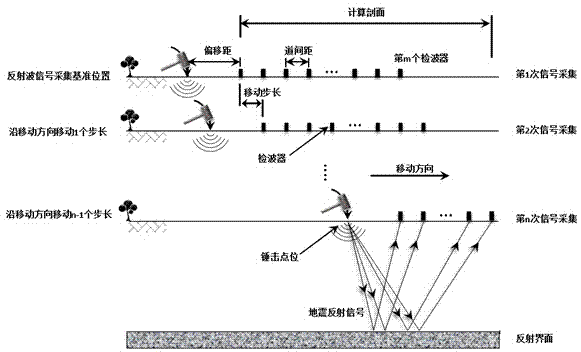
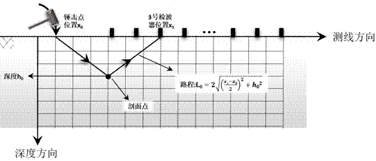
Seismic three-dimensional wave velocity scanning and focused imaging method
A technology of focusing imaging and speed scanning, applied in the field of engineering geophysical exploration, can solve the problems of superimposed speed changes, inability to perform high-precision imaging, etc., to achieve the effect of improving the signal-to-noise ratio
- Summary
- Abstract
- Description
- Claims
- Application Information
AI Technical Summary
Problems solved by technology
Method used
Image


Examples
specific Embodiment
[0071] The geological survey data of a tunnel on the "Lanzhou-Chongqing Railway" show that there are unfavorable geological conditions such as karst at the axis of the tunnel, and its specific location cannot be determined by other detection methods. After the tunnel construction is completed, seismic imaging is carried out on the tunnel inner floor along the axis.
[0072] Using the present invention to perform three-dimensional wave velocity scanning and focusing imaging on the seismic recording signals in the karst anomaly exploration area in the tunnel, the detection results are as follows: Figure 11 shown. Depend on Figure 11 It can be seen that:
[0073] 1. The karst anomaly area in the imaging map is obvious and consistent with the actual verification results.
[0074] 2. For areas with complex underground geological conditions, the vertical and lateral changes in velocity are large, and the three-dimensional scanning and focusing imaging method can better reflect ...
PUM
 Abstract
Description
Claims
Application Information
 - R&D
- Intellectual Property
- Life Sciences
- Materials
- Tech Scout
- Unparalleled Data Quality
- Higher Quality Content
- 60% Fewer Hallucinations
Browse by: Latest US Patents, China's latest patents, Technical Efficacy Thesaurus, Application Domain, Technology Topic, Popular Technical Reports.
© 2025 PatSnap. All rights reserved.Legal|Privacy policy|Modern Slavery Act Transparency Statement|Sitemap|About US| Contact US: help@patsnap.com