A gis-based power grid disaster monitoring and early warning system and method
A technology for power grid disasters and power grids, applied to alarms, instruments, etc., can solve problems such as methods for providing environmental information monitoring, and achieve the effect of reducing losses
- Summary
- Abstract
- Description
- Claims
- Application Information
AI Technical Summary
Problems solved by technology
Method used
Image
Examples
Embodiment 1
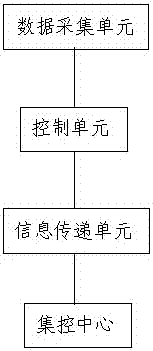
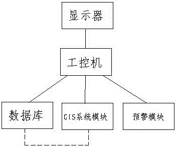
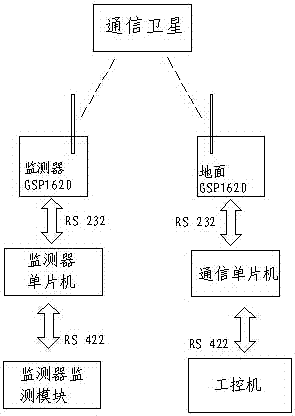
[0036] Such as Figure 1 to Figure 4 Shown: the present invention provides a kind of power grid disaster monitoring and early warning system based on GIS, comprises data acquisition unit, control unit, information transfer unit and centralized control center, described data acquisition unit, control unit, information transfer unit and centralized control The centers are connected sequentially; the data collection unit includes a monitor monitoring module and a satellite monitoring module for collecting power grid operation and surrounding environment information, and the satellite monitoring module includes remote sensing satellites for large-scale environmental information and geographical Information changes are monitored; the control unit includes a monitor single-chip microcomputer, which is used to organize the data information collected by the data acquisition unit and send it out through the information transfer unit; the information transfer unit includes a monitor GSP1...
Embodiment 2
[0041] Such as Figure 1 to Figure 4 As shown: the present invention also provides a GIS-based power grid disaster monitoring and early warning system, including a data acquisition unit, a control unit, an information transfer unit and a centralized control center, the data acquisition unit, a control unit, an information transfer unit and a centralized control center The control center is connected in sequence; the data acquisition unit includes a monitor monitoring module and a satellite monitoring module for collecting power grid operation and surrounding environment information, and the satellite monitoring module includes remote sensing satellites for large-scale environmental information and The change of geographic information is monitored; the control unit includes a monitor single-chip microcomputer, which is used to organize the data information collected by the data acquisition unit and send it out through the information transfer unit; the information transfer unit ...
Embodiment 3
[0043] Such as Figure 1 to Figure 5 Shown: the present invention also provides a kind of power grid disaster monitoring and early warning method based on GIS, comprises the following steps:
[0044] 1) Collect power grid operation and environmental information through the monitor monitoring module and satellite monitoring module, and send the data information to the centralized control center to complete the monitoring of daily power grid operation;
[0045] 2) The satellite monitoring module can realize the monitoring of large-scale environmental information changes, and can monitor the environmental information of the power grid area at a macro level, and import this information into the GIS system module and display it on the display, which is conducive to the staff's prediction of environmental changes ;
[0046] 3) The early warning module of the centralized control center compares and analyzes the historical information of the database and the collected real-time macro...
PUM
 Abstract
Description
Claims
Application Information
 - R&D
- Intellectual Property
- Life Sciences
- Materials
- Tech Scout
- Unparalleled Data Quality
- Higher Quality Content
- 60% Fewer Hallucinations
Browse by: Latest US Patents, China's latest patents, Technical Efficacy Thesaurus, Application Domain, Technology Topic, Popular Technical Reports.
© 2025 PatSnap. All rights reserved.Legal|Privacy policy|Modern Slavery Act Transparency Statement|Sitemap|About US| Contact US: help@patsnap.com


