
Personnel positioning system and method for emergency rescue

A rescue personnel and personnel positioning technology, applied in the field of personnel positioning system, can solve the problems of positioning accuracy deviation, serious cumulative error, positioning deviation, etc., and achieve the effect of ranging accuracy guarantee

Active Publication Date: 2017-10-20
NANJING WOXU COMM TECH
View PDF7 Cites 0 Cited by
  • Summary
  • Abstract
  • Description
  • Claims
  • Application Information

AI Technical Summary

Problems solved by technology

[0014] Whether it is a wireless positioning system or positioning through geomagnetic field information, there is a preprocessing factory. In a wireless positioning system, it is necessary to install base stations in advance and accurately measure the placement of base stations. Any difference in base station data will lead to positioning deviation
In some special scenarios, it is also unacceptable to install a positioning base station, such as the disaster relief site where rescuers are located
[0015] On the other hand, through geomagnetic positioning, it is necessary to mention the collection of geomagnetic information. In some specific scenarios, it is easier to obtain these data, but in the case of sudden accidents, it is no longer possible to obtain geomagnetic field data in advance.
At the same time, because the signal of the magnetic field is relatively weak, it will be affected by the accuracy of the sensor and the environment, and there will be a large deviation in the positioning accuracy
[0016] 2. Cumulative error
But in the process of movement, the error cannot be corrected through the analysis of behavior
As a result, the cumulative error is getting more and more serious, and finally the error is unacceptable

Method used


Image

  • Personnel positioning system and method for emergency rescue
  • Personnel positioning system and method for emergency rescue
  • Personnel positioning system and method for emergency rescue

Examples


Embodiment Construction

[0068] Embodiments of the present invention are described in detail below, examples of which are shown in the drawings, wherein the same or similar reference numerals denote the same or similar elements or elements having the same or similar functions throughout. The embodiments described below by referring to the figures are exemplary only for explaining the present invention and should not be construed as limiting the present invention.

[0069] Below in conjunction with accompanying drawing, technical scheme of the present invention is described in further detail:

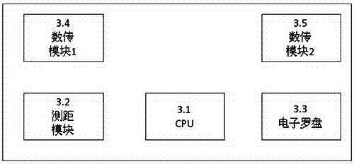
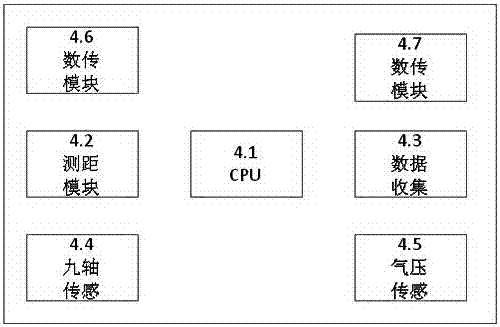
[0070] Figures of the invention figure 1 As shown, the present invention discloses a personnel positioning system and method for emergency rescue, and the system is composed of four large components:

[0071] (1) Location presentation subsystem 1 mainly processes the data of data sending and receiving subsystem 2, and then presents the specific location of rescuers through graphics.

[0072] (2) The data trans...


PUM


Abstract

The invention discloses an emergency rescue personnel location system and an emergency rescue personnel location method. The emergency rescue personnel location system comprises a position presenting subsystem, a data receiving-transmitting subsystem, a temporary location station subsystem and a personal location subsystem, wherein the temporary location station subsystem comprises a plurality of temporary location stations; the personal location subsystem comprises a plurality of personal location modules, the data receiving-transmitting subsystem is respectively connected with the position presenting subsystem and the temporary location stations, and the temporary location stations are connected with the personal location modules. The ranging distance in an open space can reach 1km, and the ranging precision is less than or equal to 3cm under 99% situation. The emergency rescue personnel location system can effectively penetrate through a load-bearing wall with the thickness of 30cm inside a room; even in a large-sized building, the effective transmission of the data also can be guaranteed. Under the outdoor situation, the transmission distance in the open space can reach 2 km, the transmission distance is more than 300m when an obstacle exists, and in order to guarantee sufficient diffraction performance, on the aspect of the wireless data transmission, a Mesh network working at 433Mhz is adopted.

Description

technical field [0001] The invention discloses a personnel positioning system and method for emergency rescue, and relates to the technical fields of wireless communication, wireless ranging, inertial navigation, sensor fusion and the like. Background technique [0002] It is impossible to search for satellite signals indoors. Therefore, it is difficult to achieve indoor positioning through satellite positioning systems such as GPS or Beidou, but indoor positioning needs widely exist. In the existing mainstream positioning systems, there are many technologies, but there are defects in some scenarios. Instructions are given below: [0003] 1. Local area wireless positioning system [0004] Local area wireless positioning systems, whether it is indoor positioning systems such as WiFi / Zigbee / UWB / CSS / BLE, or satellite-based GNSS, need to have a base station and determine the position of the base station before knowing the position of the positioned target. [0005] For exampl...

Claims


Application Information

Patent Timeline
Patent Type & Authority Patents(China)
IPC IPC(8): G01C21/16
CPCG01C21/165
Inventor 王湘肖成海张庆林
Owner NANJING WOXU COMM TECH
Learn More