System and method for remote sensing automatic extraction of large-scale water body information based on rules
A technology for automatic extraction of water body information, applied in the field of information processing, can solve the problems of decreased analysis efficiency, failure to disclose a large range of water body information, and the accuracy of information extraction with a lot of labor and labor, and achieves the effect of high precision and accurate extraction.
- Summary
- Abstract
- Description
- Claims
- Application Information
AI Technical Summary
Problems solved by technology
Method used
Image
Examples
Embodiment 1
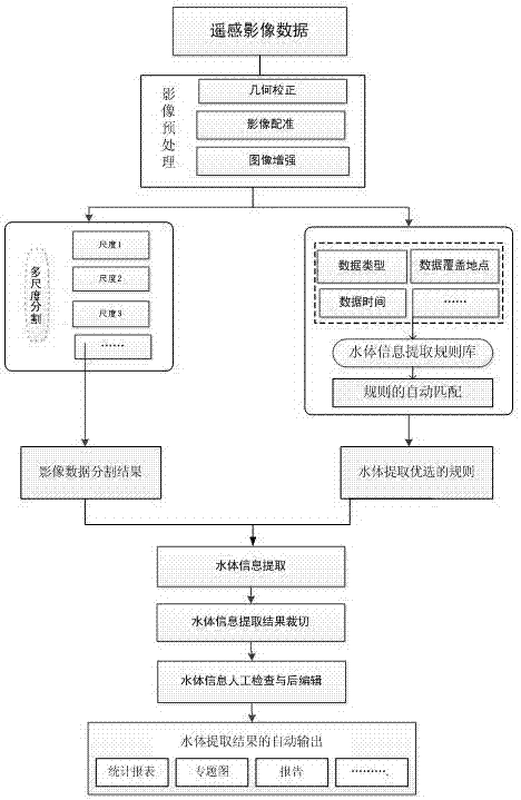
[0048] figure 1 Shown is a flow chart of the method for automatic remote sensing of large-scale water body information based on rules according to the present invention. First, the system loads remote sensing image data, wherein any film or photo that only records the size of electromagnetic waves of various ground objects is called remote sensing. Image, in remote sensing, mainly refers to aerial photos and satellite photos. After the system finishes loading the image, it performs preliminary preprocessing on the image data. The preprocessing here mainly includes geometric correction, image registration and image enhancement.
[0049] Geometric correction: During remote sensing imaging, due to the influence of factors such as the attitude, altitude, speed, and earth rotation of the aircraft, the image is geometrically distorted relative to the ground target. The error correction for geometric distortion is geometric correction. It usually refers to the correction and elimin...
Embodiment 2
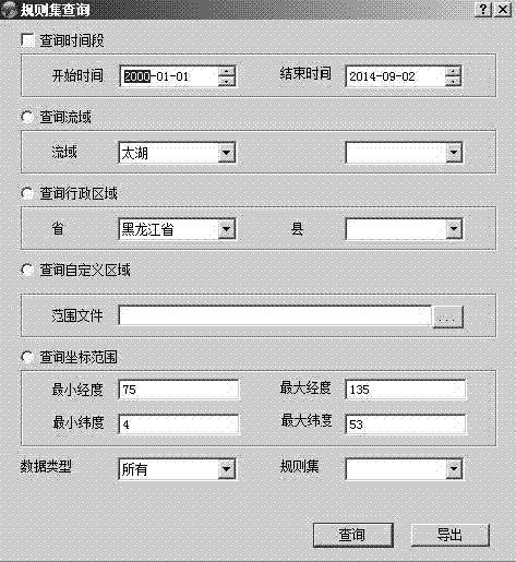
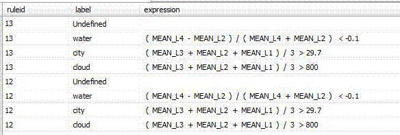
[0073] Such as figure 2 Shown is the rule set query interface diagram, including query time period, query watershed, query administrative area, query custom area and query coordinate range. The start time is January 1, 2000, and the end time is September 2, 2014; the query basin is Taihu Lake; the query administrative region is Heilongjiang Province; the query coordinate range is minimum longitude 75 maximum longitude 135, minimum dimension 4 maximum Dimension 53. Query result matching rules and corresponding rule expressions such as image 3 As shown, the water (water body) rule number 13, the expression is ( MEAN_L4 - MEAN_L2) / ( MEAN_L4 + MEAN_L2) 29.7; cloud (cloud) rule number 13, the expression is ( MEAN_L3 + MEAN_L2 + MEAN_L1) / 3 > 800.
[0074] In this embodiment, the corresponding rule set for automatic matching is obtained by inputting relevant image acquisition information. The rule set completes the feature extraction of water body information through corres...
PUM
 Abstract
Description
Claims
Application Information
 - Generate Ideas
- Intellectual Property
- Life Sciences
- Materials
- Tech Scout
- Unparalleled Data Quality
- Higher Quality Content
- 60% Fewer Hallucinations
Browse by: Latest US Patents, China's latest patents, Technical Efficacy Thesaurus, Application Domain, Technology Topic, Popular Technical Reports.
© 2025 PatSnap. All rights reserved.Legal|Privacy policy|Modern Slavery Act Transparency Statement|Sitemap|About US| Contact US: help@patsnap.com


