A method for positioning and extracting point target images in spaceborne areas

An extraction method and point target technology, applied in the field of on-orbit positioning and extraction of linear push-broom camera imaging data, can solve the problem of large data volume, and achieve the effect of improving efficiency and good system scalability

Active Publication Date: 2017-07-07
XIAN INSTITUE OF SPACE RADIO TECH
View PDF3 Cites 0 Cited by
  • Summary
  • Abstract
  • Description
  • Claims
  • Application Information

AI Technical Summary

Problems solved by technology

[0004] In the field of remote sensing satellite image processing technology, the amount of data to be processed is increasing. How to make full use of these remote sensing data is a difficulty and deficiency we face; among them, targeted image selection, real-time or non-real-time on-orbit specific processing , becomes a great challenge

Method used


Image

  • A method for positioning and extracting point target images in spaceborne areas
  • A method for positioning and extracting point target images in spaceborne areas
  • A method for positioning and extracting point target images in spaceborne areas

Examples


Embodiment Construction

[0024] The specific implementation of the present invention will be described below in conjunction with the accompanying drawings and specific implementation examples:

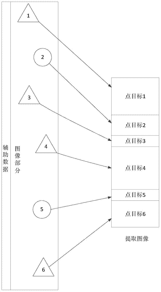
[0025] figure 1 It is a schematic diagram of regional point target image extraction after the positioning is completed; the on-orbit image contains auxiliary data and image parts, and the image part has 6 point targets, and the on-orbit image passes through 6 point targets from top to bottom; when When the first point target is reached, the size of the extracted image is as the point target 1 in the right figure; similarly, the subsequent 5 point target images are extracted in sequence; the difference in the size of the extracted images in the figure is determined by the point target extraction image output requirements .

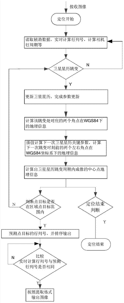
[0026] Such as figure 2 Shown, the present invention realizes steps as follows:

[0027] (1) Read the auxiliary data of the satellite image: calculate the current row and column number ...


PUM


Abstract

A method for locating and extracting point target images in a space-borne area. The method reads auxiliary data of satellite images, calculates the current row number of satellite images, judges satellite ephemeris jumps and ephemeris jump cycles, and calculates camera line cycles, etc. ; An algorithm based on parameter update and geographic information real and predictive calculation is proposed, which ensures the stability and real-time performance of positioning accuracy; judges whether the regional point target is within the current detection range, and calculates its corresponding prediction starting row number; And compare it with the real-time row and column number, and output the result according to the point target extraction format; cycle calculation until the end of the task. This method overcomes the deficiencies of the existing technology, and can use several existing satellite positioning models to realize the positioning of the remote sensing image of the satellite in orbit at any time after the satellite is powered on, and complete the real-time or non-real-time extraction of the point image of the satellite-borne area. Options are provided for high-level processing of on-orbit imagery.

Description

technical field [0001] The invention relates to a method for positioning and extracting a point target image in a space-borne area, which belongs to the technical field of remote sensing satellite image processing and is used for on-orbit positioning and extraction of imaging data of a linear push-broom camera carried by a remote sensing satellite. Background technique [0002] With the continuous launch of remote sensing satellites at home and abroad, the characteristics of large area, short period and low cost of satellite remote sensing make it the dominant direction of remote sensing development. The spatial resolution, time resolution, radiation resolution and spectral resolution of remote sensing satellites With continuous improvement, the amount of on-orbit data has increased dramatically. [0003] The linear array push-broom optical camera is the mainstream of optical remote sensing satellite sensors at present. The linear array push-broom optical camera advances wit...

Claims


Application Information

Patent Timeline
Patent Type & Authority Patents(China)
IPC IPC(8): G06K9/46G06K9/00
Inventor 王元乐孙文方郑小松杨新权李永峰肖化超
Owner XIAN INSTITUE OF SPACE RADIO TECH
Why Eureka
Try Eureka