
Unmanned aerial vehicle aeromagnetic detecting system and method

A detection system, unmanned aerial vehicle technology, applied in radio wave measurement systems, electric/magnetic exploration, motor vehicles, etc., can solve the problems of high work cost, large magnetic field interference, complicated operation, etc., to avoid electromagnetic interference, avoid The effect of collision short circuit and ensuring flight safety

Active Publication Date: 2014-10-29
INST OF REMOTE SENSING & DIGITAL EARTH CHINESE ACADEMY OF SCI
View PDF4 Cites 58 Cited by
  • Summary
  • Abstract
  • Description
  • Claims
  • Application Information

AI Technical Summary

Problems solved by technology

[0006] Aiming at the shortcomings of existing aeromagnetic detection systems, such as complex operation, high work cost, low efficiency, large magnetic field interference, and low level of intelligent integration, the present invention proposes an aeromagnetic detection system using a low-magnetic unmanned aerial vehicle as a platform, which can Reduce the cost of aeromagnetic detection, improve the quality of magnetic measurement data, suitable for the application of large-area high-precision aeromagnetic measurement work

Method used


Image

  • Unmanned aerial vehicle aeromagnetic detecting system and method
  • Unmanned aerial vehicle aeromagnetic detecting system and method
  • Unmanned aerial vehicle aeromagnetic detecting system and method

Examples


Embodiment Construction

[0049] The present invention will be described in further detail below in conjunction with the embodiments and accompanying drawings.

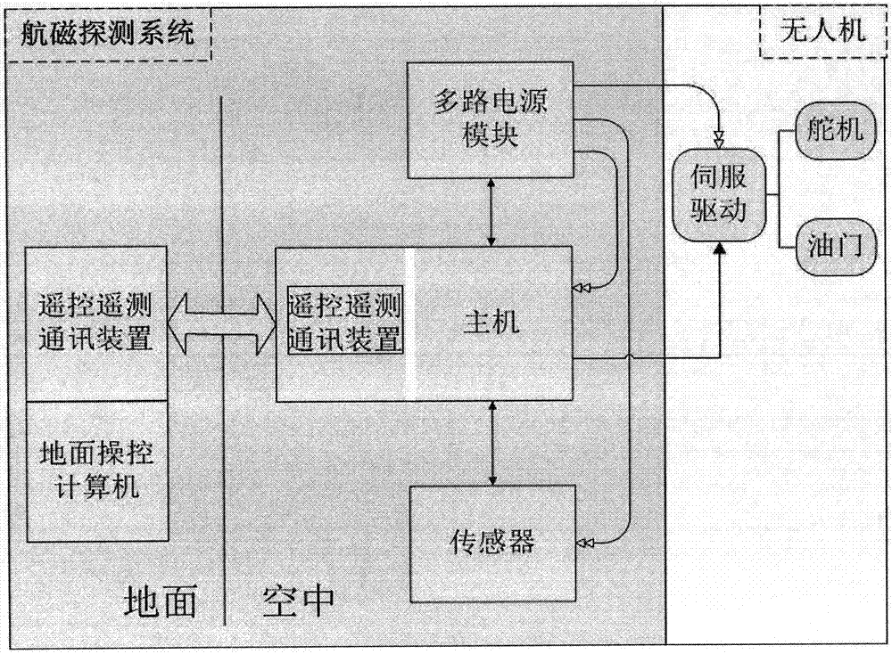
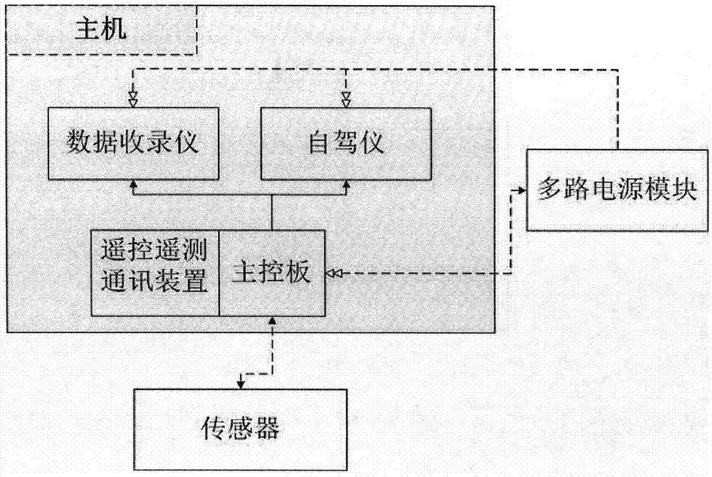
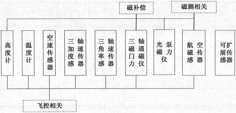
[0050] The invention mainly uses the optical pump magnetometer as the core magnetic sensor for measuring the geomagnetic field, and integrates the supporting data recording system and autopilot into the automatic flight control and communication host part of the system, and is equipped with a large-capacity battery module and other sensors. Aeromagnetic detection system for UAVs. Choose the fixed-wing UAV model and install the aeromagnetic measurement system on the UAV to realize a complete set of UAV aeromagnetic detection system.

[0051] The fixed-wing UAV is selected as a conventional layout, double vertical tail, double tail brace, rear engine, and large aspect ratio wing. The aircraft has good stability and can maintain stable flight, which can meet the flight requirements of aeromagnetic detection under different terrain conditions. . ...


PUM


Abstract

The invention relates to an unmanned aerial vehicle aerial magnetic field detecting system and method and belongs to the technical field of novel airborne geophysical prospecting instruments. The detecting system specifically comprises an onboard portion and a ground portion, the onboard portion comprises a host, a multi-way power supply module and a sensor system, the host is connected with a servo motor of an unmanned aerial vehicle, the host comprises a main control panel, an onboard remote control telemetering communication device, an automatic driving navigator and a data recording instrument, the ground portion is used for controlling over taking off and landing of the unmanned aerial vehicle, real-time monitoring of measuring states and manual intervention in emergencies, and the ground portion comprises a ground remote control telemetering communication device, a remote-control unit, a ground control computer and a processing module. The unmanned aerial vehicle aeromagnetic detecting system and method can be used for aspects of underground mineral resource prospection and military target detection and for prospecting or strategic resource exploring of future 'earth-observing engineering' and national key construction projects. According to the unmanned aerial vehicle aeromagnetic detecting system and method, the technical scheme of aeromagnetic detection is simple and easy to implement, low in costs and remarkable in social benefits and economic benefits.

Description

technical field [0001] The invention relates to an aerial magnetic field detection system and method of an unmanned aerial vehicle, belonging to the technical field of new aerial geophysical prospecting instruments. Background technique [0002] Magnetic prospecting is a geophysical prospecting method that studies the distribution of geological structures and mineral resources (or other detection objects) by observing and analyzing magnetic anomalies caused by magnetic differences in rocks and ores (or other detection objects). Can be used in all stages of geological surveys. Applications in regional geological surveys include: ① Carry out tectonic division, study deep and large faults, determine contact zone, fault zone, fracture zone and basement structure; ② divide the distribution range of sedimentary rock, intrusive rock, extrusive rock and metamorphic rock, Carry out regional geological mapping; ③ study the formation and distribution of regional minerals. The applica...

Claims


Application Information

Patent Timeline
IPC IPC(8): G01V3/40B64C39/02
Inventor 郭子祺张宝钢刘建英乔彦超秦静欣田野
Owner INST OF REMOTE SENSING & DIGITAL EARTH CHINESE ACADEMY OF SCI
Learn More