Geographic information data distribution service method and system

A geographic information data and geographic information service technology, which is applied in the field of geographic information data distribution services, can solve the problems of massive data and high concurrent access bottlenecks, and achieve the effects of improving file access efficiency, increasing transmission speed, and reducing pressure

Active Publication Date: 2017-12-08
BEIJING SUPERMAP SOFTWARE CO LTD
View PDF3 Cites 0 Cited by
  • Summary
  • Abstract
  • Description
  • Claims
  • Application Information

AI Technical Summary

Problems solved by technology

[0006] The technical problem to be solved by the present invention is to provide a geographical information data distribution service method, which can solve the problem of high concurrent access bottleneck of massive data in the wide-area complex network environment in the prior art

Method used


Image

  • Geographic information data distribution service method and system
  • Geographic information data distribution service method and system
  • Geographic information data distribution service method and system

Examples


Embodiment Construction

[0034] In order to make the above objects, features and advantages of the present invention more comprehensible, the present invention will be further described in detail below in conjunction with the accompanying drawings and specific embodiments.

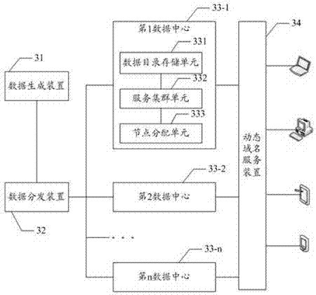
[0035] In the following method embodiments, in order to solve the problem that the existing geographic information web services cannot meet the high concurrent service requirements of multi-source massive space, the system adopts a multi-data center architecture to realize data distributed distribution, synchronization and load balancing services.

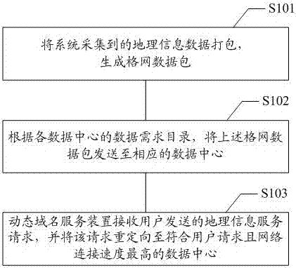
[0036] refer to figure 1 , showing the flow of the first embodiment of the geographical information data distribution service method of the present invention, specifically including:

[0037] Step S101: Pack the geographic information data collected by the system to generate a grid data packet;

[0038]Step S102: Send the grid data packet to the corresponding data center according to ...


PUM


Abstract

The present invention provides a geographic information data distribution service method and system. The system for executing the method includes more than two data centers. The method includes: packaging the geographic information data collected by the system to generate a grid data package ; According to the data demand directory of each data center, the grid data packet is sent to the corresponding data center; the dynamic domain name service device receives the geographical information service request sent by the user, and redirects the geographical information service request to the corresponding user The data center with the highest internet connection speed requested. The invention solves the concurrency bottleneck problem caused by the wide-area complex network environment existing in the single data center scheme of the traditional geographical information Web service through the data distribution mode of the distributed multi-data center.

Description

technical field [0001] The invention relates to the technical field of geographical information data services, in particular to a geographical information data distribution service method and system. Background technique [0002] Geographical information Web service is a group of functional entities related to geographic information in the Internet environment, which exposes encapsulated functions through its calling interface. The existing geographic information service (GIS, Geographic Information System) includes GIS data service and GIS function service. GIS data service provides spatial data through interface, and GIS function service provides spatial data processing function through interface. [0003] With the maturity and development of spatial information technologies and industries such as location services (LBS, Location Based Service), high-resolution satellite remote sensing, and street view services, the speed of spatial information collection has been greatly ...

Claims


Application Information

Patent Timeline
Patent Type & Authority Patents(China)
IPC IPC(8): H04L29/08
Inventor 黄骞王尔琪滕寿威
Owner BEIJING SUPERMAP SOFTWARE CO LTD
Why Eureka
Try Eureka