Video abstract generating method based on GIS

A video summarization and monitoring video technology, applied in the field of image processing, can solve the problems of inability to analyze and predict the video content space, obtain the target location, etc., and achieve the effect of expanding GIS data sources, improving processing efficiency, and reducing data volume

Inactive Publication Date: 2014-03-26
SHENZHEN INST OF ADVANCED TECH
View PDF5 Cites 22 Cited by
  • Summary
  • Abstract
  • Description
  • Claims
  • Application Information

AI Technical Summary

Problems solved by technology

However, the video data itself cannot be used as an effective data source for GIS at present, that is, GIS cannot directly obtain the target location and its moving trajectory from the video, and cannot perform spatial analysis and prediction on the video content.

Method used


Image

  • Video abstract generating method based on GIS
  • Video abstract generating method based on GIS
  • Video abstract generating method based on GIS

Examples


Embodiment 1

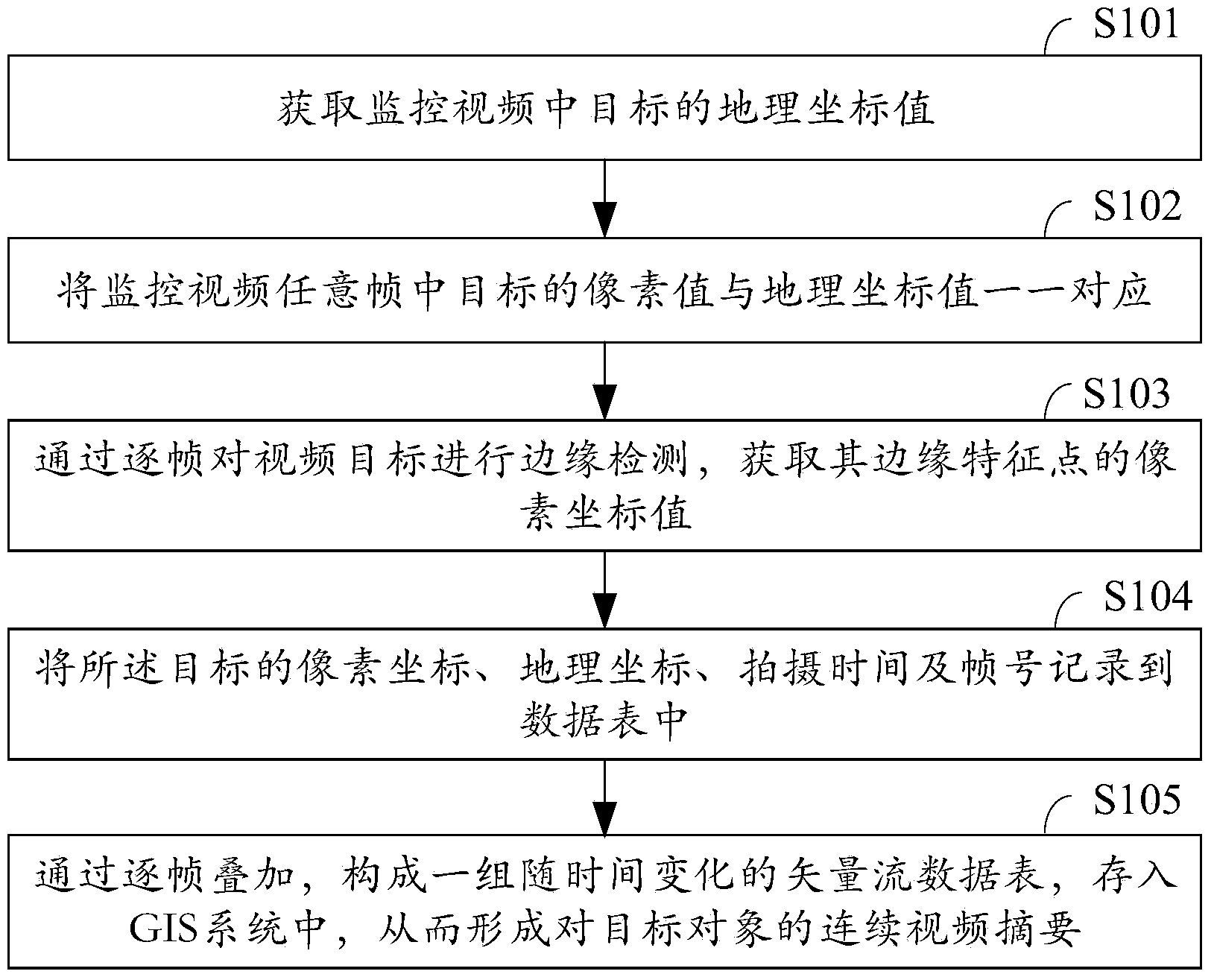
[0017] When the monitoring video does not include location information, first, establish a spatial positioning system centered on the video monitoring equipment. For details, refer to the patent CN201310071391.1, a spatial positioning method based on video analysis.

[0018] Then, the geographic coordinate data of the target within the monitoring range of the video surveillance equipment is obtained. For the method, please refer to the patent CN201310675740.0, the positioning and tracking method based on the video surveillance network.

Embodiment 2

[0020] When the monitoring video includes location information, the geographic coordinates of the target are directly obtained. That is, some video data itself contains geographic coordinates, and the captured geographic coordinates will be recorded when uploading or recording video data, as shown in patent CN201310443078.6, a method for adding geographic location information to video files and building an index.

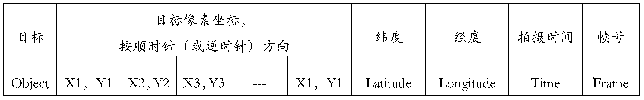
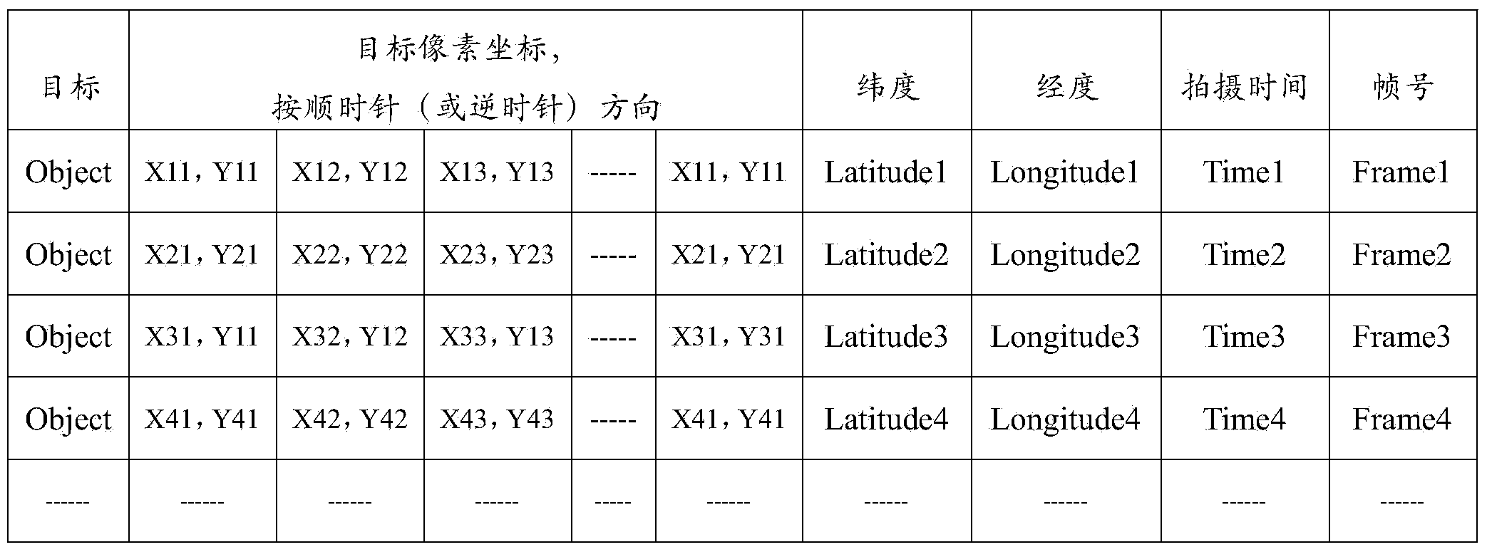
[0021] In step S102, the pixel coordinates of the target in any frame of the surveillance video are in one-to-one correspondence with the geographic coordinates.

[0022] In this step, if the video data involved comes from multiple video devices, the spatial integration and association of video data between multiple video devices should be considered, such as patent CN201310105427.3, a multi-video associated monitoring based on spatial information As shown in the positioning apparatus and method, video data from different sources are integrated.

[0023] If the vid...


PUM


Abstract

The invention provides a video abstract generating method based on a GIS. The video abstract generating method comprises the first step of acquiring the geographical coordinates of targets in a surveillance video, the second step of enabling the pixel coordinates of the targets in any frame of the surveillance video to correspond to the geographical coordinates in a one-to-one mode, the third step of carrying out edge detecting on the targets in the surveillance video frame by frame to obtain the pixel coordinates of edge features of the targets, the fourth step of recording the pixel coordinates, the geographical coordinates, the shooting time and the frame numbers to a data table, and the fifth step of overlapping the frames one by one to form a vector stream data table changing along with time, converting the original surveillance video into the coordinate value set of the pixel coordinates, the longitude and latitude and the shooting time and storing the coordinate value set into the GIS to form a continuous video abstract of the target object. By means of the video abstract generating method, the data size is effectively reduced, the processing efficiency is improved, the GIS data sources are effectively expanded, and the dynamism and real-time performance of the GIS are promoted.

Description

technical field [0001] The invention relates to image processing technology, in particular to a GIS-based video summary generation method. Background technique [0002] Geographic Information System (Geographic Information System or Geo-Information system, GIS), combined with geography, cartography, remote sensing and computer science, has been widely used in different fields, and is used to input, store, query, analyze and display geographic data computer system. Generally, GIS spatial data includes vectors, images, GPS, etc. [0003] Video data is generated from realistic geographic scenes and has strong spatial characteristics. However, the video data itself cannot be used as an effective data source for GIS at present, that is, GIS cannot directly obtain the target location and its moving trajectory from the video, and cannot perform spatial analysis and prediction on the video content. [0004] Therefore, how to quickly obtain the continuous motion of geographical ob...

Claims


Application Information

Patent Timeline
Patent Type & Authority Applications(China)
IPC IPC(8): G06T7/00H04N7/18
Inventor 修文群
Owner SHENZHEN INST OF ADVANCED TECH
Why Eureka
Try Eureka