
Method adjusting color of navigation map according to luminance of screen

A screen brightness and navigation map technology, applied in the field of navigation, can solve the problems of high cost and achieve the effects of simple operation, guaranteed clarity, increased comfort and driving safety

Active Publication Date: 2013-12-25
SHENYANG MXNAVI CO LTD
View PDF8 Cites 10 Cited by
  • Summary
  • Abstract
  • Description
  • Claims
  • Application Information

AI Technical Summary

Problems solved by technology

This causes the CPU to have a particularly large overhead in the process of floating-point operations, requiring multiple instruction cycles to complete a floating-point operation

Method used


Image

  • Method adjusting color of navigation map according to luminance of screen
  • Method adjusting color of navigation map according to luminance of screen
  • Method adjusting color of navigation map according to luminance of screen

Examples


Embodiment 1

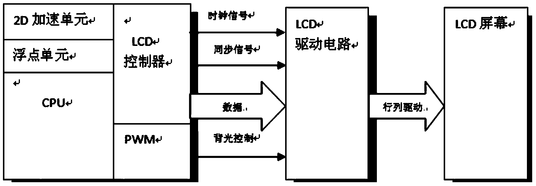
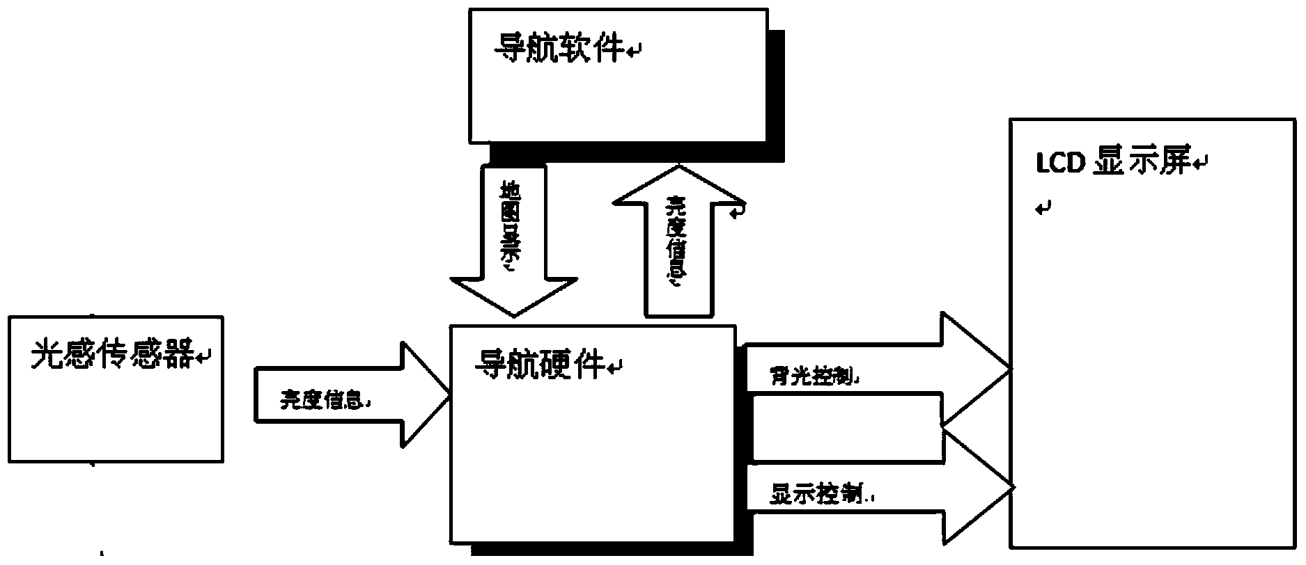
[0047] This embodiment provides a method for adjusting the color of the navigation map according to the brightness of the screen, which is characterized in that: the method for adjusting the color of the navigation map according to the brightness of the screen is that the backlight of the navigation system is manually set by software, and can also be controlled by a light sensor , the software or the light sensor changes the duty cycle of the PWM to form different LCD backlight control voltages and produce different brightness, thereby controlling the brightness of the screen display;

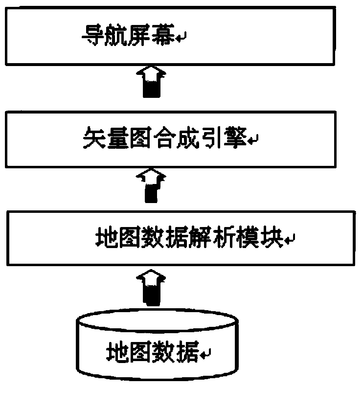
[0048] The navigation software obtains the brightness information of the LCD. When drawing a map, the vector graphics engine will generate a background color corresponding to the brightness of the backlight to generate an electronic map. The background color of the map on the LCD screen can fully adapt to the brightness of the backlight, making the display content better. clear;

[0049] Map da...


PUM


Abstract

The invention provides a method adjusting the color of a navigation map according to the luminance of a screen. Backlight of a navigation system is manually set through software and can also be controlled through a light sensation sensor. The software or the light sensation sensor changes the duty ratio of PWM to form different kinds of LCD backlight control voltage and generate the luminance of different degrees, so that the display luminance of the screen is controlled. According to the navigation software, the luminance information of an LCD is obtained, when the map is drawn, a vector diagram engine can generate the background color corresponding to the backlight luminance, an electronic map is generated, and the map background color on the LCD screen can completely adapt to the backlight luminance, so that contents are displayed well and clearly. The method has the advantages that the operation complexity of the navigation system is lowered, and navigation equipment can be more intelligent and humanized. In the driving process, the problem of eye fatigue caused by the excessively high luminance of the LCD is solved, and the comfort to use the navigation map in the driving process and the driving safety are improved.

Description

technical field [0001] The invention relates to the field of navigation, in particular to a method for adjusting the color of a navigation map according to screen brightness. Background technique [0002] Vector graphics: Vector graphics are graphics drawn by a computer based on geometric properties. [0003] PWM: The abbreviation of "Pulse Width Modulation", referred to as pulse width modulation. [0004] Duty cycle: In the pulse cycle sequence, the ratio of the duration of the positive pulse to the total cycle of the pulse. [0005] LCD: Abbreviation for "Liquid Crystal Display", that is, liquid crystal display. [0006] D / A conversion: convert digital signal to analog signal. [0007] Gamma: The nonlinear relationship between its brightness and input voltage. [0008] Hue: One of the attributes of color, used to distinguish different colors. [0009] With the continuous development of navigation technology, the utilization rate of navigation terminals is getting high...

Claims


Application Information

Patent Timeline
Patent Type & Authority Applications(China)
IPC IPC(8): G09G3/36G09G3/34
Inventor 徐良徐小光王海世
Owner SHENYANG MXNAVI CO LTD
Learn More