Landform three-dimensional dynamic analog display method and system

A three-dimensional dynamic, analog display technology, applied in the field of geographic information, can solve the problem of not supporting large-scale terrain rendering

Inactive Publication Date: 2013-11-27
SATELLITE SURVEYING & MAPPING APPL CENTSASMAC NAT ADMINISTATION OF SURVEYING MAPPING & GEOINFORMATION OF CHINANASG
View PDF4 Cites 4 Cited by
  • Summary
  • Abstract
  • Description
  • Claims
  • Application Information

AI Technical Summary

Problems solved by technology

However, this method is mostly limited to the terrain representation of small scenes and does not support large-scale terrain rendering
[0005] In summary, the dynamic terrain expression method in related technologies has the technical defect of not supporting large-scale terrain rendering

Method used


Image

  • Landform three-dimensional dynamic analog display method and system
  • Landform three-dimensional dynamic analog display method and system
  • Landform three-dimensional dynamic analog display method and system

Examples


Embodiment Construction

[0060] The present invention will be described in further detail below through specific implementation examples and in conjunction with the accompanying drawings.

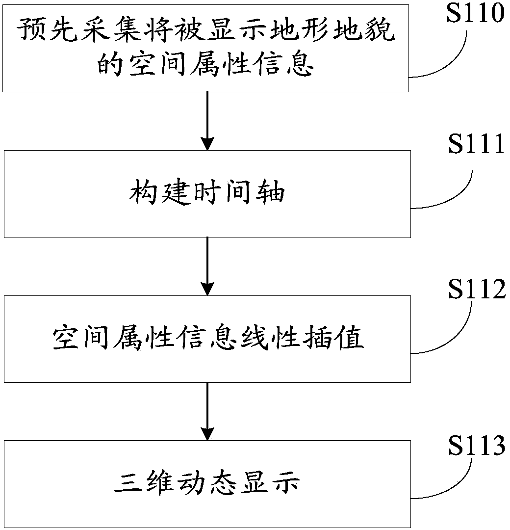
[0061] The embodiment of the present invention provides a three-dimensional dynamic simulation and display method of topography and topography, which controls, simulates and realizes dynamic three-dimensional visualization of topography and topography in the real world through a time axis object and linear interpolation of spatial attributes. Its realization mainly includes three parts: establishment of visual simulation time axis, initialization of time elements; linear interpolation calculation of spatial attributes; dynamic three-dimensional visualization display. Specifically, see figure 1 shown, including steps:

[0062] Step S110: Pre-collect the spatial attribute information of the topography to be displayed.

[0063] In the embodiment of the present invention, preferably, the spatial attribute information...


PUM


Abstract

The invention relates to the technical field of geographic information, in particular to a landform three-dimensional dynamic analog display method and system. The landform three-dimensional dynamic analog display method comprises the steps that spatial attribute information of a landform to be displayed is collected in advance; actual time in the spatial attribute information is divided through first time nodes, simulated time in the spatial attribute information is divided through second time nodes, and the actual time and the simulated time are mapped to the same time axis according to the time duration proportional relation; the spatial attribute information of the second time nodes is calculated in a linear mode, and linear interpolation is carried out on the spatial attribute information of the second time nodes; each second time node on the time axis is traversed, and the spatial attribute information corresponding to each second time node is displayed and updated. The landform three-dimensional dynamic analog display system comprises a collection module and a display control module. The landform three-dimensional dynamic analog display method and system have the advantages that analog display of images with higher precision can be achieved, and limitation of the size of a collection area is avoided.

Description

technical field [0001] The invention relates to the technical field of geographic information, in particular to a method and system for three-dimensional dynamic simulation and display of topography and geomorphology. Background technique [0002] Topography and geomorphology refer to the change of terrain elevation. As a common expression content of outdoor scenes, topography and geomorphology can not only serve as the main background of the virtual scene, but also provide positioning standards for other elements in the scene, which plays a very important role. How to accurately express the topography (for example, display in the form of an electronic image) is one of the important research topics for those skilled in the art. [0003] The traditional representation of terrain and landform is often static, that is, during the simulation process of the whole scene, once the terrain data is loaded, it cannot be modified. However, with the continuous improvement of people's r...

Claims


Application Information

Patent Timeline
Patent Type & Authority Applications(China)
IPC IPC(8): G06T17/05
Inventor 甘宇航雷兵周平徐畅胡轶之高崟
Owner SATELLITE SURVEYING & MAPPING APPL CENTSASMAC NAT ADMINISTATION OF SURVEYING MAPPING & GEOINFORMATION OF CHINANASG
Why Eureka
Try Eureka