Doppler velocity log (DVL) parameter calibration method used for integrated navigation system of underwater inertial navigation system (INS) and DVL

An integrated navigation system and integrated navigation technology, applied in the field of DVL parameter calibration, can solve problems such as difficult to ensure the installation accuracy of DVL and INS, difficult to meet the high-precision requirements of long-range underwater vehicles, and complicated operations

Inactive Publication Date: 2013-06-19
NAT UNIV OF DEFENSE TECH
View PDF2 Cites 21 Cited by
  • Summary
  • Abstract
  • Description
  • Claims
  • Application Information

AI Technical Summary

Problems solved by technology

For the above-mentioned method of using precision processing technology, the cost is high, and it is difficult to ensure the installation accuracy between DVL and INS, which leads to the decline of INS / DVL integrated navigation positioning accuracy; and for the above-mentioned whole process, GNSS signals are used to calibrate DVL In terms of parameters, the underwater vehicle must be surfaced to receive GNSS signals, so there are also disadvantages such as complicated operation
[0004] All in all, the existing DVL parameter calibration methods in the INS / DVL integrated navigation of long-range underwater vehicles all have shortcomings such as high cost and complicated operation, and it is difficult to meet the increasingly urgent high-precision requirements of high-precision INS / DVL integrated navigation of long-range underwater vehicles

Method used


Image

  • Doppler velocity log (DVL) parameter calibration method used for integrated navigation system of underwater inertial navigation system (INS) and DVL
  • Doppler velocity log (DVL) parameter calibration method used for integrated navigation system of underwater inertial navigation system (INS) and DVL
  • Doppler velocity log (DVL) parameter calibration method used for integrated navigation system of underwater inertial navigation system (INS) and DVL

Examples


Embodiment Construction

[0038] The present invention will be further described in detail below in conjunction with the accompanying drawings and specific embodiments.

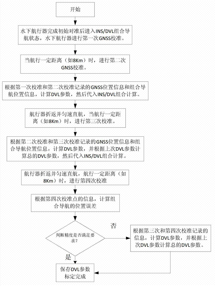
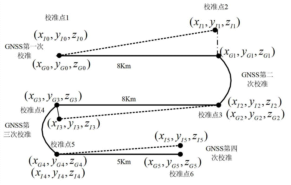
[0039] Such as figure 1 and figure 2 Shown, the DVL parameter calibration method that is used for underwater INS and DVL integrated navigation system of the present invention, its flow process is:

[0040] (1) The first GNSS calibration: After the underwater vehicle completes the initial alignment, enter the SINS / DVL integrated navigation state, surface to receive GNSS signals, perform the first GNSS calibration, and record when the last GNSS position is valid The position of the integrated navigation based on the earth-centered earth-fixed coordinate system (x I0 ,y I0 ,z I0 ) and GNSS position information based on the earth-centered earth-fixed coordinate system (x G0 ,y G0 ,z G0 ), as the information of figure 2 Calibration point 1 shown;

[0041] (2) The second GNSS calibration: the underwater vehicle sails directly at ...


PUM


Abstract

The invention relates to a doppler velocity log (DVL) parameter calibration method used for an integrated navigation system of an underwater inertial navigation system (INS) and a DVL. The procedures includes the following steps: (1) calibrating a global navigation satellite system (GNSS) for the first time after initial alignment of an underwater aircraft is completed, (2) calibrating the GNSS for the second time after the underwater aircraft directly sails at a constant speed for a certain distance, (3) calculating the parameter of the DVL according to position information of the two calibrated GNSS and position information of the integrated navigation, (4) calibrating the GNSS for the third time after the aircraft pulls back and directly sails at a constant speed for a certain distance, calculating the parameter of the DVL, and iteratively calculating the total parameter of the DVL according to the former parameter of the DVL, (5) and calibrating the GNSS for the forth time after the aircraft pulls back and directly sails at a constant speed for a certain distance, calculating position error of the integrated navigation according to position information of the forth calibrated integrated navigation and the position information of the GNSS, and judging whether accuracy meets requirements, and if the accuracy meets requirements, calibration is completed, if the accuracy does not meet the requirements, the calibration is completed through iterative calculation. The DVL parameter calibration method used for the integrated navigation system of the underwater INS and the DVL has the advantages of being simple in calculation, high in accuracy, simple in operation and the like.

Description

technical field [0001] The present invention mainly relates to the field of navigation systems, in particular to a DVL parameter mainly applicable to the combined navigation of long-distance underwater vehicle inertial navigation system (Inertial Navigation System, INS) and Doppler Velocity Log (DVL). calibration method. Background technique [0002] Due to the long-range characteristics of long-range underwater vehicles, a single navigation system cannot meet the needs. Inertial navigation has the advantages of autonomy and high short-term positioning accuracy, but has the disadvantage of accumulating position errors over time; GNSS (Global Navigation Satellite System) navigation and positioning accuracy is high, and positioning errors do not accumulate over time, but it has weak anti-interference ability and cannot Insufficient for underwater navigation and so on. SINS / DVL integrated navigation uses the high-precision velocity information provided by DVL to suppress the ...

Claims


Application Information

Patent Timeline
Patent Type & Authority Applications(China)
IPC IPC(8): G01S7/40
Inventor 唐康华曹聚亮潘献飞吴文启胡小平吴美平江明明
Owner NAT UNIV OF DEFENSE TECH
Why Eureka
Try Eureka