System and method for correcting imaging parameter error of remote sensing camera

An imaging parameter error and remote sensing camera technology, which is applied in the field of digital images, can solve the problems of high cost, no correction and adjustment of system parameter errors, and difficulty in recovery, etc., to overcome low detection accuracy, single correction parameters, The effect of detection method flexibility

Inactive Publication Date: 2015-04-08
XIDIAN UNIV
View PDF8 Cites 0 Cited by
  • Summary
  • Abstract
  • Description
  • Claims
  • Application Information

AI Technical Summary

Problems solved by technology

The disadvantage of this compensation mechanism is that the detection system can only improve the imaging effect of the original remote sensing camera, and cannot detect and correct the existing system errors
The disadvantages of this compensation system are: the compensation system is directly installed in the spaceborne imaging system, its existence will increase the load and power consumption of the satellite, the implementation cost is relatively high, and it can only correct a single system parameter error
The disadvantage of this method is that it can only detect and correct a single image motion factor, and there are many types of error parameters that cause image blur, and it is impossible to set up a corresponding detection system for each error parameter. Moreover, the correction system is carried on the spaceborne imaging system, which increases the load and power consumption of the satellite, and the implementation cost is relatively high.
The disadvantage of this type of method is that this method only improves the quality of the image, but does not improve the imaging quality. This processing method will cause two insurmountable problems: (1) Once the imaging system is blurred, It is necessary to restore each image acquired by the imaging system, and the calculation pressure of the ground system is high; (2) the system parameter error is not corrected and adjusted, and the system parameter error may increase with time. The image quality is getting worse and worse, and more and more information is lost in the imaging process, which in turn brings more difficulties to recovery

Method used


Image

  • System and method for correcting imaging parameter error of remote sensing camera
  • System and method for correcting imaging parameter error of remote sensing camera
  • System and method for correcting imaging parameter error of remote sensing camera

Examples


Embodiment Construction

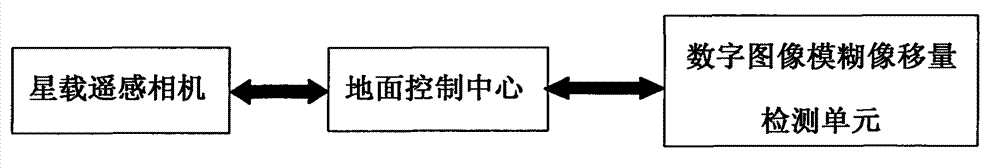
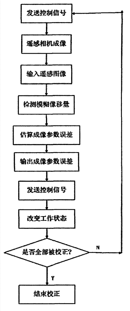
[0047] Attached below figure 1 , to further describe the system of the present invention.

[0048] The remote sensing camera imaging parameter error correction system includes a ground control center, a spaceborne remote sensing camera and a digital image blurred image motion detection unit.

[0049] The ground control center sets the increase range of the imaging parameter error of the remote sensing camera, sends a control signal that can change the camera state to the remote sensing camera, receives the remote sensing image downloaded from the remote sensing camera, and inputs the remote sensing image to the digital image blur image motion detection unit , and receiving the imaging parameter error of the remote sensing camera output by the digital image blurred image motion detection unit, is the connection part between the remote sensing camera and the digital image blurred image motion detection unit. The space-borne remote sensing camera is mounted on the satellite, and...


PUM


Abstract

The invention discloses a system and a method for correcting an imaging parameter error of a remote sensing camera, and mainly solves the problem that the imaging parameter error of the conventional remote sensing camera is difficult to detect and correct. The system disclosed by the invention comprises three constituent parts, namely a ground control center, a satellite-borne remote sensing camera and a digital image fuzzy image motion value detection unit. Parameter correction is realized by the steps of: (1) sending a control signal to a satellite by the ground control center; (2) imaging by using the remote sensing camera; (3) inputting an remote sensing image; (4) detecting a fuzzy image motion value; (5) estimating the imaging parameter error of the remote sensing camera; (6) carrying out camera system parameter correction by sending the control signal through the ground control center; and (7) judging whether the correction on an imaging parameter of the remote sensing camera is finished. According to the system and the method for correcting the imaging parameter error of the remote sensing camera, under the premise that no load is increased to the remote sensing camera, the high-precision, low-cost and high-instantaneity imaging parameter correction on the satellite-borne remote sensing camera is realized, and meanwhile, the imaging quality of an in-orbit remote sensing camera is greatly improved.

Description

technical field [0001] The invention belongs to the technical field of digital images, and further relates to a remote sensing camera imaging parameter error correction system and method in the remote sensing camera system parameter correction field. The present invention takes on-orbit image real-time analysis as the core and ground parameter control as the means, through the cooperation of the three components of the ground control center, the space-borne remote sensing camera and the digital image fuzzy image motion detection unit, to establish under-satellite detection and on-satellite correction image quality improvement framework. The invention can be used for fine adjustment of system parameters and improvement of imaging quality of a space-borne high-resolution remote sensing camera that adopts integral time-delay electrical coupling device (TDI-CCD) imaging. Background technique [0002] Spaceborne remote sensing imaging is one of the important means of earth obser...

Claims


Application Information

Patent Timeline
Patent Type & Authority Patents(China)
IPC IPC(8): G01C25/00
Inventor 王晓甜石光明张犁李甫张佩钰齐飞赵光辉林杰董伟生牛毅
Owner XIDIAN UNIV
Why Eureka
Try Eureka