
Remote sensing geophysical exploration system and remote sensing geophysical exploration method

A technology for remote sensing and objects to be measured, applied in the field of remote sensing geophysical exploration systems, it can solve the problems of inability of objects to function, limited measurement range, and inability to survey objects with deeper depths, etc., to achieve the effects of rapid survey, small drift and simple operation.

Active Publication Date: 2013-12-18
河北坤宇物探科技有限公司
View PDF6 Cites 0 Cited by
  • Summary
  • Abstract
  • Description
  • Claims
  • Application Information

AI Technical Summary

Problems solved by technology

[0002] The output voltage of existing remote sensing geophysical detectors is between 2.4V and 3V. The load transmitting antenna needs to be placed 10 cm to 20 cm deep underground, and the measurement range is limited. It can't work on objects below 20 meters underground, can't survey deep objects, and can't remotely search and orient a large area from one point

Method used


Image

  • Remote sensing geophysical exploration system and remote sensing geophysical exploration method
  • Remote sensing geophysical exploration system and remote sensing geophysical exploration method

Examples


Embodiment Construction

[0045] The technical solutions of the various embodiments of the present invention will be clearly and completely described below in conjunction with the accompanying drawings. Apparently, the described embodiments are only some of the embodiments of the present invention, not all of them. Based on the embodiments of the present invention, all other embodiments obtained by persons of ordinary skill in the art without making creative efforts belong to the protection scope of the present invention.

[0046] The invention provides a remote sensing geophysical detection system, comprising:

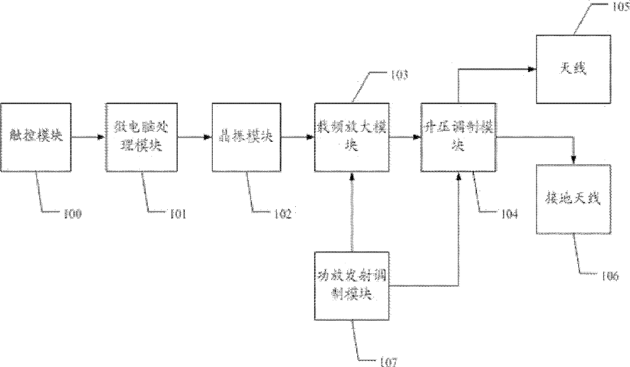
[0047] Microcomputer processing module, crystal oscillator module, carrier frequency amplification module, step-up modulation and receiving module, two antennas;

[0048] The microcomputer processing module is used to determine the standard oscillating frequency value according to the object to be tested, and trigger the crystal oscillator module to emit electromagnetic waves of the standard o...


PUM


Abstract

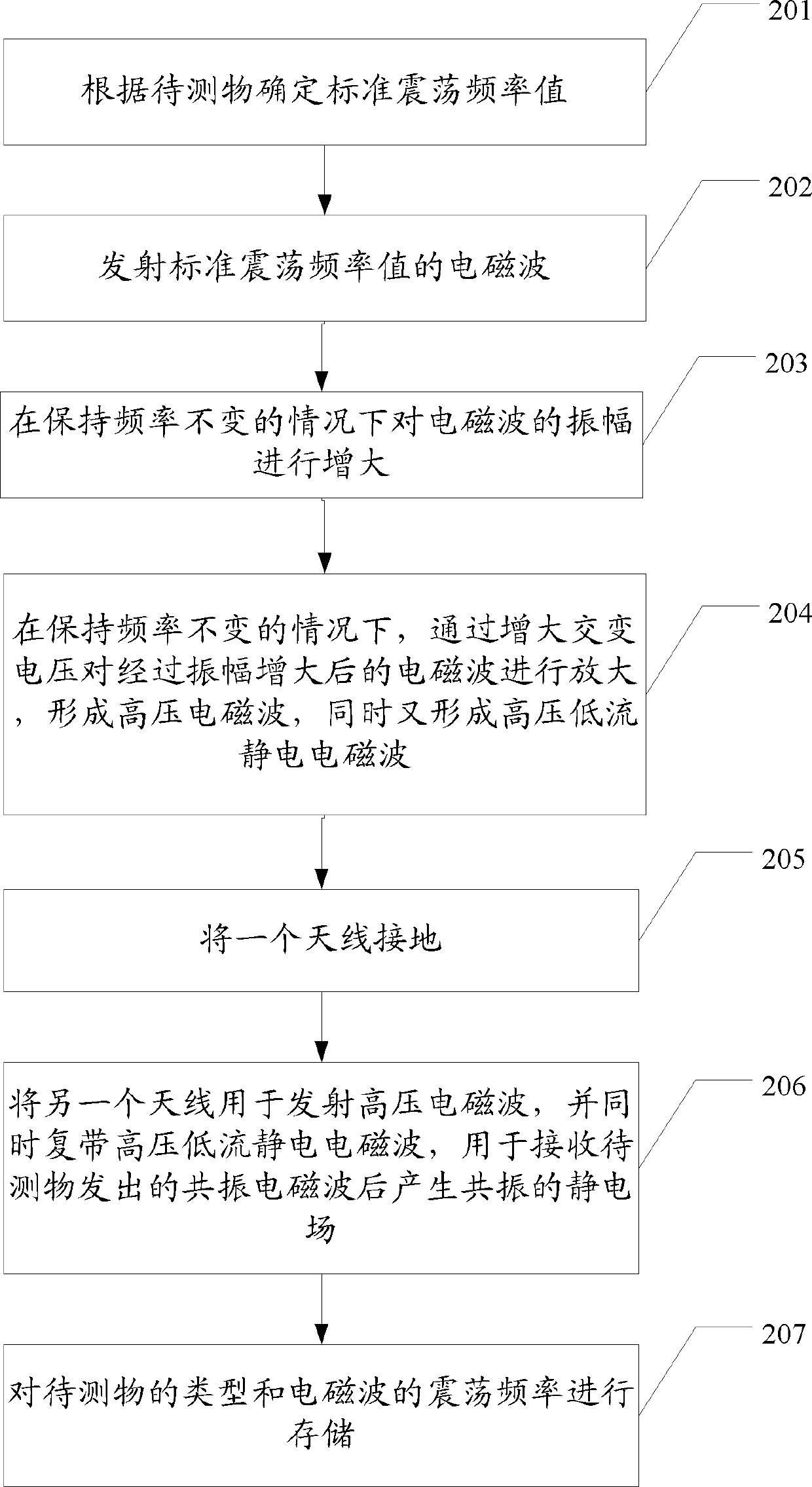
The invention relates to the machinery field, concretely relates to a remote sensing geophysical exploration system and a remote sensing geophysical exploration method, and an object can be explored remotely with large depth. The remote sensing geophysical exploration system comprises a micro computer processing module used for determining a standard oscillation frequency value according to an object to be measured and triggering a crystal oscillator module to emit an electromagnetic wave with the standard oscillation frequency value, the crystal oscillator module used for emitting the electromagnetic wave with the standard oscillation frequency value, a carrier frequency amplification module used for increasing amplitude of the electromagnetic wave in the condition that frequency is not changed, a boost modulation and reception module used for amplifying the electromagnetic wave which goes through an amplitude increase treatment by the carrier frequency amplification module through increasing alternate voltage in the condition that the frequency is not changed to form a high voltage electromagnetic wave and form a high voltage low current static electromagnetic wave simultaneously, and two antennas, wherein one antenna is grounded, and the other antenna is used for emitting the high voltage electromagnetic wave, and the two antennas carry the high voltage low current static electromagnetic wave simultaneously and are used for receiving a resonance electrostatic field emitted by the object to be measured.

Description

technical field [0001] The invention relates to the mechanical field, in particular to a remote sensing geophysical prospecting system and a remote sensing geophysical prospecting method. Background technique [0002] The output voltage of existing remote sensing geophysical detectors is between 2.4V and 3V. The load transmitting antenna needs to be placed 10 cm to 20 cm deep underground, and the measurement range is limited. It can't work on objects below 20 meters underground, can't survey deep objects, and can't remotely search and orientate a large area from one point. Contents of the invention [0003] Through the remote sensing geophysical prospecting system and the remote sensing geophysical prospecting method provided by the present invention, the azimuth and orientation of objects can be searched in remote areas, and objects with deep depths can be surveyed. [0004] The invention provides a remote sensing geophysical detection system, comprising: [0005] Micro...

Claims


Application Information

Patent Timeline
Patent Type & Authority Patents(China)
IPC IPC(8): G01V3/12
Inventor 刘文国刘飒伟
Owner 河北坤宇物探科技有限公司
Learn More