Eureka AIR delivers breakthrough ideas for toughest innovation challenges, trusted by R&D personnel around the world.

Bus transfer inquiry method based on geographic information system (GIS) classification

A query method and bus technology, applied in special data processing applications, instruments, electrical digital data processing, etc., can solve the problem that users and passengers are difficult to remember the name of the station, and achieve the effect of rich travel options.

Inactive Publication Date: 2012-05-02
THE 3RD ACAD 8358TH RES INST OF CASC
View PDF8 Cites 24 Cited by
  • Summary
  • Abstract
  • Description
  • Claims
  • Application Information

AI Technical Summary

Problems solved by technology

Its disadvantages and shortcomings are: it is necessary to use Chinese characters to input the name of the station to be queried, and it is difficult for passengers to remember the name of each station
Among them, to achieve the fast goal, multiple factors need to be considered: number of transfers, waiting time, bus running time, walking distance, degree of congestion in the bus, etc. Therefore, the current bus line calculation methods have defects and cannot meet the needs of users

Method used


Image

  • Bus transfer inquiry method based on geographic information system (GIS) classification
  • Bus transfer inquiry method based on geographic information system (GIS) classification
  • Bus transfer inquiry method based on geographic information system (GIS) classification

Examples


Embodiment Construction

[0048] Below in conjunction with accompanying drawing and embodiment, a kind of GIS classification-based bus transfer inquiry method provided by the present invention is introduced:

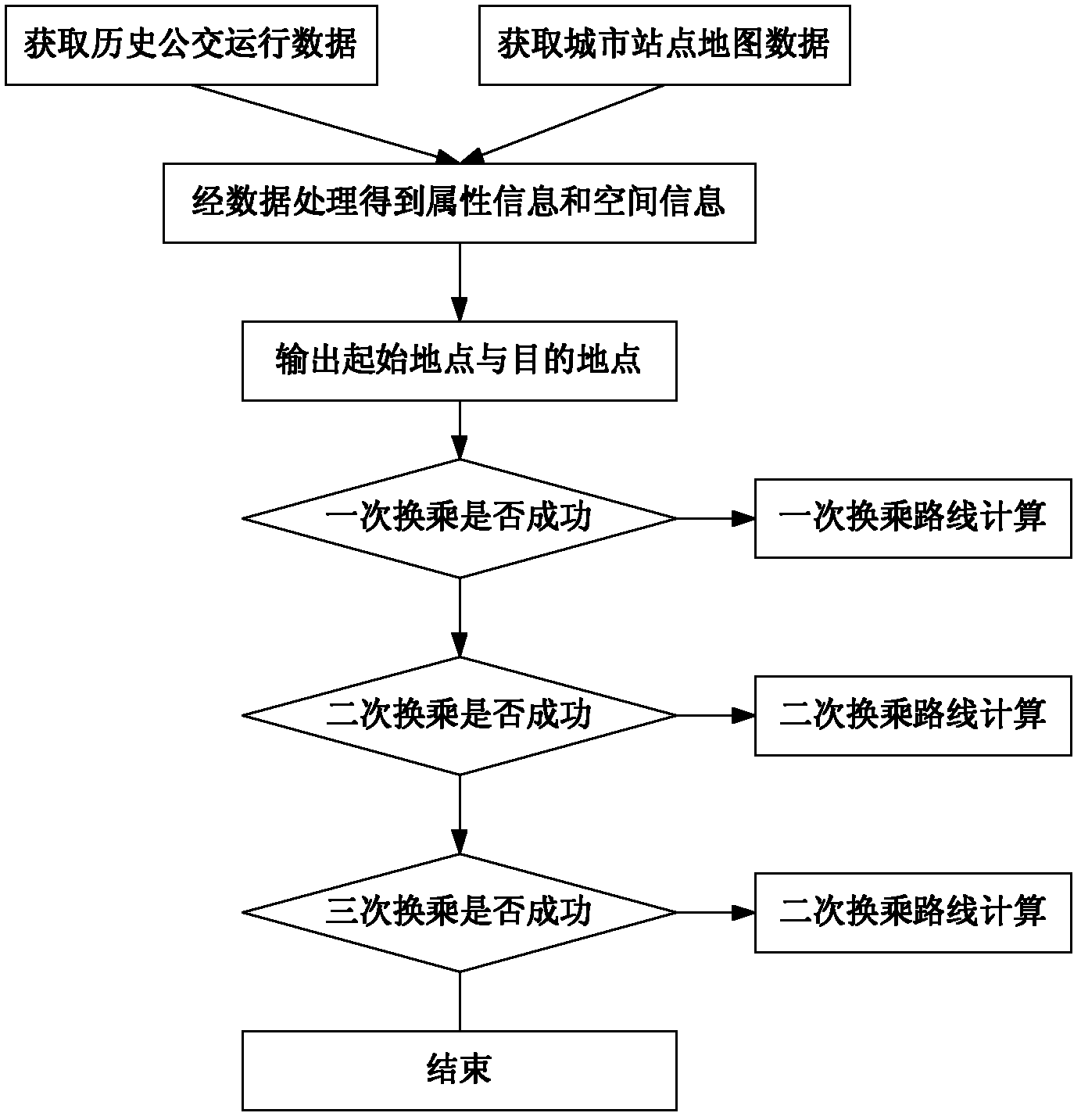
[0049] Such as figure 1 As shown, a GIS classification-based interactive method for bus transfer query includes the following steps,

[0050] (1) Establish a database to obtain historical bus operation data and city site map data. The historical bus operation data should include: line number, vehicle number, station number, entry time (that is, the moment of arrival at the station), number of passengers on board, etc.

[0051] The station data shall include: station label, and the uplink and downlink directions shall be distinguished in the station label; station name; longitude and latitude.

[0052] (2) Data processing steps

[0053] (2.1) Divide the whole day into multiple time periods. Usually, the bus operation is divided into 6 peak sections: morning peak, morning peak, afternoon peak, ...


PUM


Abstract

The invention relates to the field of intelligent public traffics and in particular relates to a bus transfer inquiry interaction method based on geographic information system (GIS) classification, and the method is used for meeting a requirement of a user for traveling comfortableness. The bus transfer inquiry interaction method comprises the following steps of: (1) establishing a database, namely acquiring historical bus running data and urban station map data; (2) processing data, namely establishing a line station transfer parameter table and associating the attribute data in the line station transfer parameter table with the space data in a GIS, wherein the line station transfer parameter table comprises the waiting time, and the running time when a vehicle runs from a previous station to a next station; and (3) calculating transfer inquiry, namely calculating and comparing comprehensive traveling costs of different schemes during inquiry of a bus line scheme between two stations. By utilizing the method, the connection data of the bus stations and running conditions of buses at respective time periods on respective stations are classified and sequenced through a GIS technology; therefore, a user can select the optimal scheme which is suitable for the own comfortableness.

Description

technical field [0001] The invention relates to the field of intelligent public transportation, in particular to a GIS classification-based interactive method for querying bus transfers. Background technique [0002] With the continuous advancement of public transportation informatization in recent years, a considerable number of buses have installed GPS positioning systems, on-board monitoring systems, passenger flow collection and other systems. From another point of view, information such as the running time of each road section, the congestion situation in the bus, and the waiting time of each station can be obtained in different time periods of many urban buses. It's just that the different types of information that can be obtained are different because of the varying degrees of bus informationization in various places. At the same time, with the continuous advancement of the bus informationization process, this information continues to increase. However, so much infor...

Claims


Application Information

Patent Timeline
Patent Type & Authority Applications(China)
IPC IPC(8): G06F17/30
Inventor 董振超李洋张霞霍建立
Owner THE 3RD ACAD 8358TH RES INST OF CASC
Why Eureka
Eureka Blog
Learn More