W90221X-based global positioning system (GPS) electronic marine map navigator
An electronic chart and navigator technology, which is applied in the field of GPS electronic chart navigator based on W90221X, can solve the problems of high equipment cost, few chart markers, high cost of use, etc., and achieve high system integration and software confidentiality Good performance and low development cost
Inactive Publication Date: 2012-04-11
楼然苗 +1
View PDF4 Cites 13 Cited by
- Summary
- Abstract
- Description
- Claims
- Application Information
AI Technical Summary
Problems solved by technology
At present, these equipment basically rely on imports, the equipment price is high, maintenance is difficult, and the conditions of use at sea are poor. Generally, the equipment has to be bought new in 2-5 years, and the cost of use is relatively high.
However, there are very few domestically produced navigation equipment in my country, and most of them are assembled or labeled for sale. There is a manufacturer of GPS chartplotters in Shenzhen, and there is no manufacturer in Zhejiang Province.
The imported GPS locators and electronic charts currently on the market have the following main disadvantages: 1. The charts used by the GPS chartplotters are relatively old, and the domestic navigation channels are also changing in recent years, and the charts made abroad There are few markers on the map, the sea area is incomplete, and the information is unknown, especially along the coast, which has the largest change, which brings a large error to the navigation reference
3. The cost of equipment is high, generally around 10,000 yuan
4. Using industrial computer as the main processor, the system stability and confidentiality are poor
Method used
View moreImage
Smart ImageViewing Examples

Examples
Embodiment Construction
[0014] Units with relevant technical needs or production intentions can negotiate and negotiate in various ways such as technology transfer and cooperative production.
Login to View More PUM
 Abstract
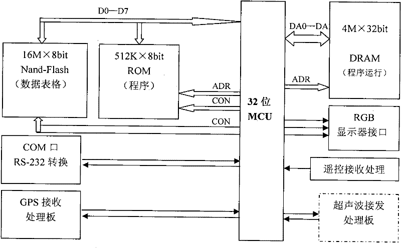
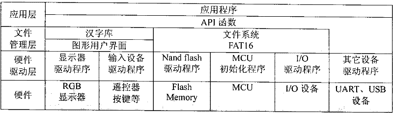
The invention discloses a W90221X-based global positioning system (GPS) electronic marine map navigator, and belongs to the field of application of computer embedded electronic marine map navigators. The home-made electronic marine map navigator with GPS navigation function used in inland seas is researched and produced. The electronic marine map navigator is designed by adopting full-automatic embedded software and hardware; and a global coordinate system, self-made regional charts of China and partial inland charts of the Yangtze River channel, the water area of Taihu Lake and the like are adopted in the electronic marine map navigator. Main information capable of being displayed by a host screen comprises real-time Gregorian calendar, lunar calendar date and Beijing time, real-time position (longitude and latitude), speed and direction of a ship, longitude and latitude of a cursor point, distance between the cursor point and the ship, direction of the cursor point, marine topographic maps (which can be zoomed in and out and can display the information such as marine area names, navigation marks, water depth and the like) around the ship, and other comprehensive information (such as sweater temperature, power supply voltage, satellite state and the like). A host has the main functions of determining a navigation mode, recording ship positions, a man-overboard boat (MOB), way points, marks and ship routes, editing the ship positions, the way points, the marks, the ship routes and courses, viewing the MOB, calling the way points, the ship positions, the ship routes and anchor points, setting display, parameters, delivery and positioning, measuring the distance, displaying the calendar, data and front views and the like.
Description
Technical field [0001] Computer embedded (electronic chart navigator) application. Background technique [0002] In recent years, with the development of science and technology, navigational instruments have developed rapidly, especially navigational aids related to shipping safety have attracted the attention of the government and ship owners. Among them, GPS locators, electronic charts, and seabed depth sounders (also used for fish detection) are high-tech products in recent years. They are necessary equipment for merchant ships, fishing boats, work boats, yachts, etc. All ships must be equipped with equipment such as GPS locators, electronic charts, etc. At present, these equipments are basically dependent on imports. The equipment prices are high, maintenance is difficult, and the conditions of use at sea are poor. Generally, the equipment has to be bought new in 2-5 years, and the cost of use is relatively high. However, there are very few domestically produced naviga...
Claims
Login to View More Application Information
Patent Timeline
 Patent Type & Authority Applications(China)
IPC IPC(8): G01C21/00
Inventor 楼然苗陈斌
Owner 楼然苗
Features
- R&D
- Intellectual Property
- Life Sciences
- Materials
- Tech Scout
- Unparalleled Data Quality
- Higher Quality Content
- 60% Fewer Hallucinations
Learn More Browse by: Latest US Patents, China's latest patents, Technical Efficacy Thesaurus, Application Domain, Technology Topic, Popular Technical Reports.
© 2025 PatSnap. All rights reserved.Legal|Privacy policy|Modern Slavery Act Transparency Statement|Sitemap|About US| Contact US: help@patsnap.com