Method for determining sea surface topographic structure based on barodynamics

A measurement method and gravity technology, applied in the direction of measuring device, electromagnetic wave reradiation, radio wave measurement system, etc., can solve the problems of insufficient representation of observation data, difficulty in obtaining centimeter-level geoid, and low accuracy of results

Inactive Publication Date: 2011-08-31
CHINESE ACAD OF SURVEYING & MAPPING
View PDF4 Cites 13 Cited by
  • Summary
  • Abstract
  • Description
  • Claims
  • Application Information

AI Technical Summary

Problems solved by technology

Method ② requires the long-term observation of temperature and salinity data from coastal hydrological stations across the country to calculate the seawater density value. Moreover, the deployment range of hydrological stations is limited, and the observation data are not representative enough, so it is difficult to obtain convincing results of offshore sea surface topography
Method ③ is a development trend in the study of sea surface topography. However, the gravity field model used by Engelis is too old, and the satellite altimetry data is relatively simple. The results calculated by the function model have low accuracy and the effect is not ideal
[0008] In my country's offshore waters, even under the conditions of accurately measuring sea surface wind pressure and three-dimensional continuous seawater temperature and salinity distribution, it is impossible to obtain a steady-state sea surface topography with an accuracy better than 20cm by using marine physics methods
Therefore, in shallow sea areas, it is difficult to obtain the centimeter-level geoid only by using a variety of satellite altimetry data to separate the sea surface topography by ocean physical methods.

Method used


Image

  • Method for determining sea surface topographic structure based on barodynamics
  • Method for determining sea surface topographic structure based on barodynamics

Examples


Embodiment Construction

[0042] The specific implementation manners of the present invention will be described in further detail below in conjunction with the accompanying drawings and examples. The following examples are used to illustrate the present invention, but are not intended to limit the scope of the present invention.

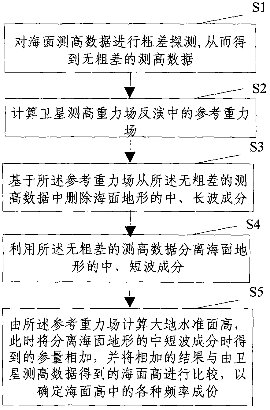
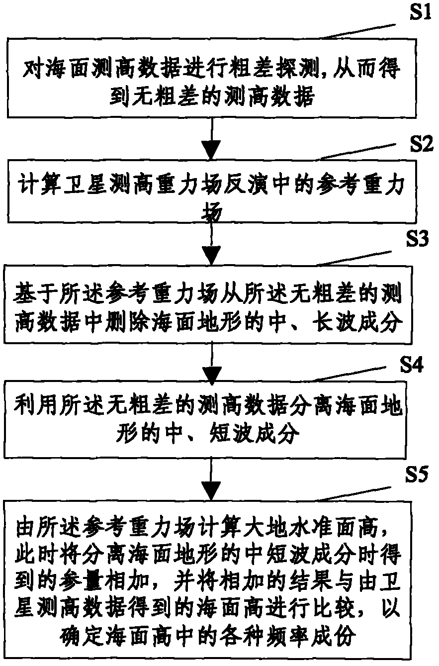
[0043] Such as figure 1 Shown, the gravity-based sea topographic structure determination method provided by the invention comprises the following steps:

[0044] S1. Gross error detection is performed on the sea surface altimetry data, so as to obtain altimetry data without gross errors;

[0045] S2, calculating the reference gravity field in the inversion of satellite altimetry gravity field;

[0046] S3. Deleting long-wave components in sea surface terrain from the altimetry data without gross errors based on the reference gravity field;

[0047] S4. Using the altimetry data without gross errors to separate the medium and short wave components of the sea surface topograp...


PUM


Abstract

The invention discloses a method for determining sea surface topographic structure based on barodynamics, which comprises the following steps: S1, performing the gross error detection on sea surface height data to obtain a gross error-free height data; S2, calculating a reference gravity field in satellite altimetry gravity field inversion; S3, based on the reference gravity field, deleting long-wave components in the sea surface topography from the gross error-free height data; S4, utilizing the gross error-free height data to separate the intermediate wave components in the sea surface topography; and S5, in the calculation of a geoid height by utilizing the reference gravity field, adding parameters which are acquired in the step of separating the intermediate wave components in the sea surface topography, and comparing the added result with a sea surface height acquired according to a satellite altimetry data so as to determine various frequency components in the sea surface height. By using the method, the reliable sea surface height data is acquired, thereby acquiring the accurate measured sea surface topographic structure data.

Description

technical field [0001] The invention relates to the technical field of physical geodesy, in particular to a gravity-based sea topographic structure determination method. Background technique [0002] Sea surface topography is the difference between the mean sea level and the geoid. The research on sea surface topography is of great significance for determining the shape and size of the earth, establishing national elevation datums, determining ocean circulation, and changes in global ocean climate. The methods for calculating sea surface topography include: geometric leveling method, calculation of sea surface topography in China's coastal waters from hydrological data, and spherical harmonic function expansion method based on satellite altimetry data. [0003] Sea topography separation has always been a technical bottleneck in the application of satellite altimetry in geodesy and ocean physics. In offshore shallow waters, seawater is coupled by complex factors such as sho...

Claims


Application Information

Patent Timeline
Patent Type & Authority Applications(China)
IPC IPC(8): G01S7/48G01S17/89
Inventor 柯宝贵章传银张利明
Owner CHINESE ACAD OF SURVEYING & MAPPING
Why Eureka
Try Eureka