
Vehicle real-time route optimization method and vehicle-mounted terminal

An in-vehicle terminal and real-time route technology, applied in the field of vehicle GPS navigation, can solve the problems of inconvenience of driving and the adjustment of the impossible driving route, and achieve the effect of convenient driving and alleviating traffic congestion.

Inactive Publication Date: 2010-07-07
YITUO SCI & TECH CO LTD SHENZHEN
View PDF0 Cites 29 Cited by
  • Summary
  • Abstract
  • Description
  • Claims
  • Application Information

AI Technical Summary

Problems solved by technology

However, in actual use, the road conditions change at any time. If the driver encounters temporary conditions such as road congestion during driving, he cannot make optimal adjustments to the driving route in time, which will bring a lot of inconvenience to driving.

Method used


Image

  • Vehicle real-time route optimization method and vehicle-mounted terminal
  • Vehicle real-time route optimization method and vehicle-mounted terminal
  • Vehicle real-time route optimization method and vehicle-mounted terminal

Examples


Embodiment Construction

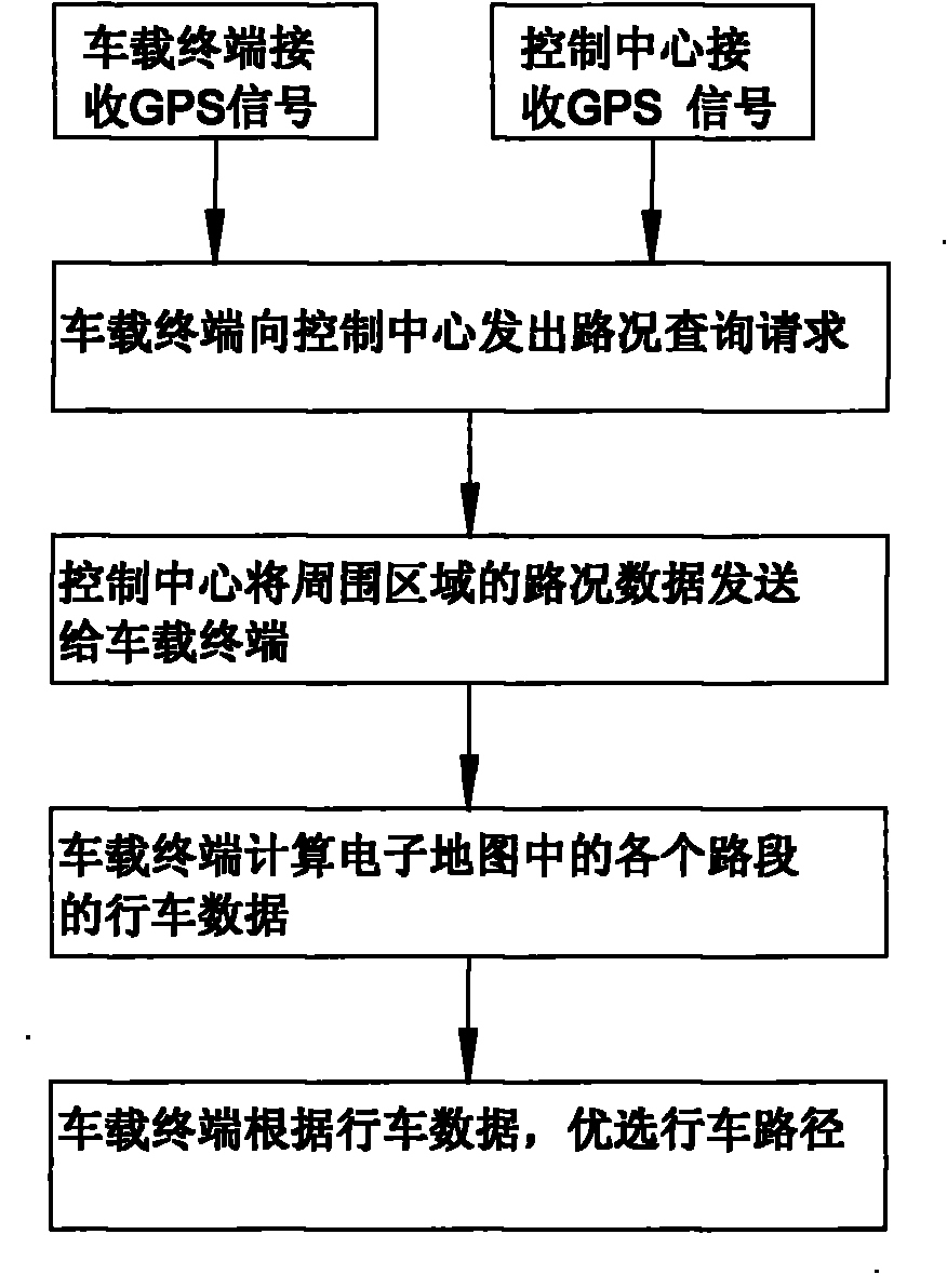
[0018] like figure 1 As shown, a method for vehicle real-time path optimization, comprising the following steps:

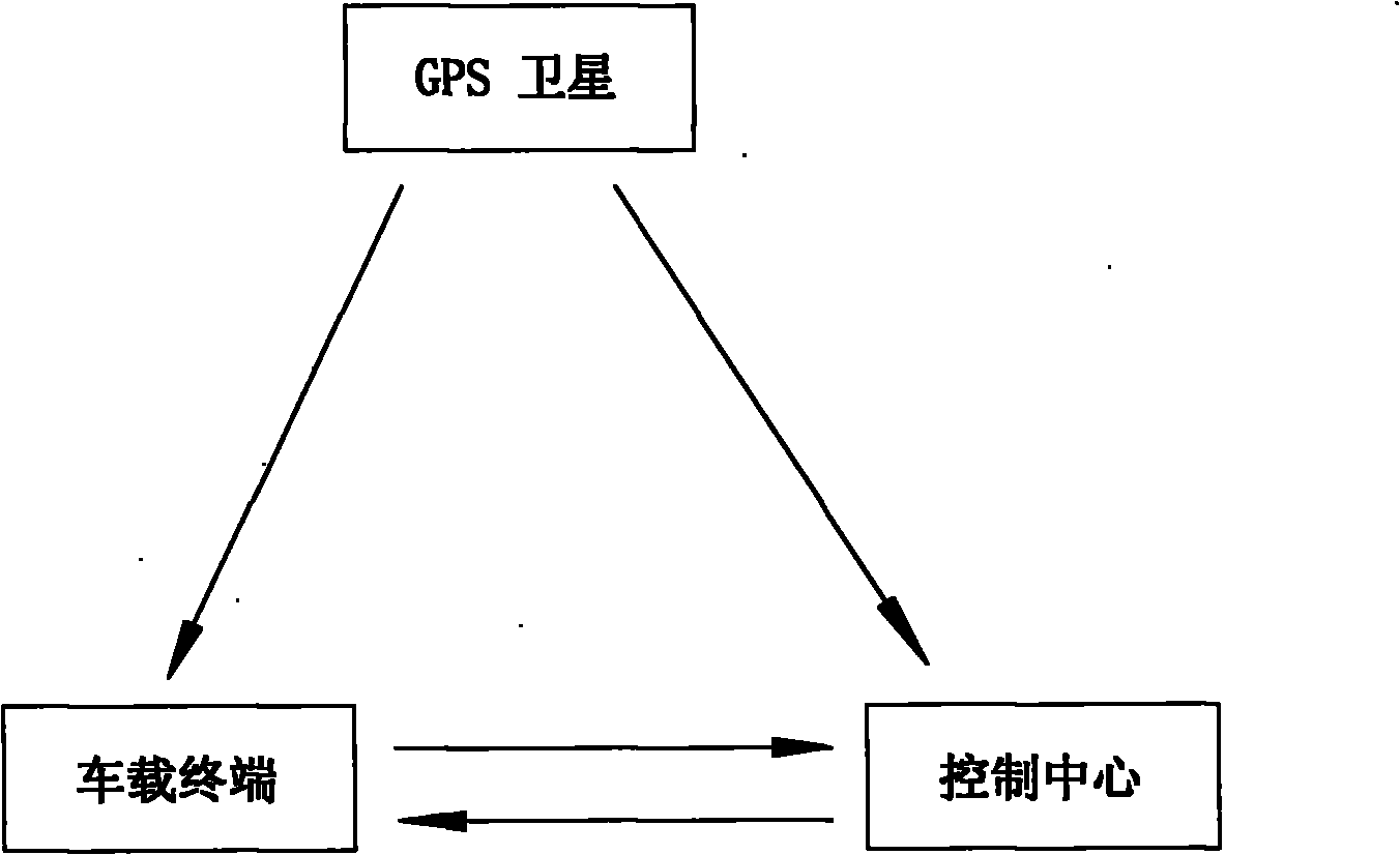
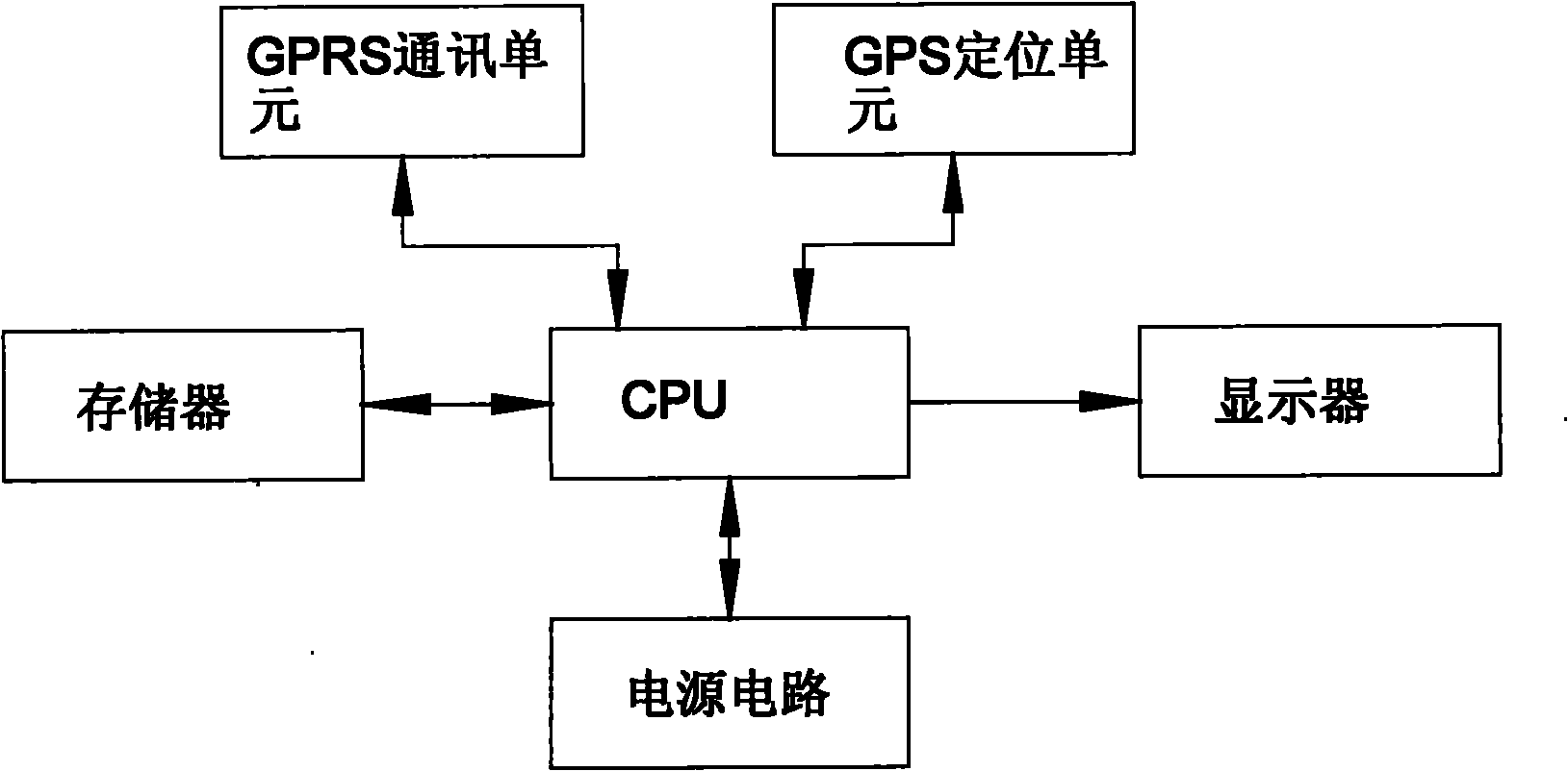
[0019] a) The vehicle-mounted terminal receives the GPS signal through the GPS positioning unit, and obtains the state information of its own vehicle: see figure 2 and image 3 The vehicle-mounted terminal includes a CPU and a GPS positioning unit connected to the CPU. The CPU calculates information such as the position, direction, and speed of the own vehicle from the signals collected by the GPS positioning unit, stores them in the cache, and outputs the relevant data to the connected display.

[0020] b) The control center receives GPS signals to obtain traffic status information in specific areas: see figure 2 , the control center on the ground accepts the information data of GPS, thus obtains the signal data of all vehicles traveling in the area.

[0021] c) The control center sends the traffic status information of the surrounding area to the vehicle-m...


PUM


Abstract

The invention discloses a vehicle real-time route optimization method and a vehicle-mounted terminal. The method comprises the following steps: a) the vehicle-mounted terminal receives a GPS signal through a GPS positioning unit to obtain the state information of the vehicle; b) a control center receives a GPS signal to obtain the traffic state information of a special region; c) the control center transmits the traffic state information of the surrounding region of the vehicle-mounted terminal to the vehicle-mounted terminal through a wireless communication network according to a request of the vehicle-mounted terminal; d) the vehicle-mounted terminal calculates the driving data of all routes on an electronic map according to the received traffic state information; and e) the vehicle-mounted terminal outputs an optimal navigation paths according to the driving data of all routes and the set navigation rules. The vehicle-mounted terminal of the invention can receive the traffic state information data sent by the GPS satellite signal and control center to adjust and output the optimal drive circuit, thus facilitating the drive of the driver and decrease the congestion of road traffic.

Description

technical field [0001] The invention relates to the field of vehicle GPS navigation, in particular to a method for optimizing a vehicle's real-time route and a vehicle-mounted terminal. Background technique [0002] The existing vehicle-mounted GPS navigation device can calculate the optimal route for the driver according to the driver's departure place, destination, transit place, etc. according to the set navigation route planning principles such as the shortest time principle, the shortest distance principle, and the highway optimization principle. driving path, or simply provide the driver with status information such as the position, speed, altitude, direction, etc. of the own vehicle. However, in actual use, the road conditions change at any time. If the driver encounters temporary conditions such as road congestion during driving, he cannot make optimal adjustments to the driving route in time, which brings a lot of inconvenience to driving. Contents of the inventio...

Claims


Application Information

Patent Timeline
Patent Type & Authority Applications(China)
IPC IPC(8): G01C21/34G01C21/36G08G1/0969
Inventor 宋美华
Owner YITUO SCI & TECH CO LTD SHENZHEN
Learn More