Image simulation method based on continuous multiple-point geostatistics method, soft data and hard data

A technology of image simulation and statistical method, applied in seismic signal processing and other directions, it can solve the problems of unable to correctly reflect the correlation of two points in space, difficult to characterize the geometric shape of spatial structure, difficult to characterize the geographical objects of long-distance curve shape and so on.

Inactive Publication Date: 2010-06-09
SHANGHAI SECOND POLYTECHNIC UNIVERSITY
View PDF0 Cites 17 Cited by
  • Summary
  • Abstract
  • Description
  • Claims
  • Application Information

AI Technical Summary

Problems solved by technology

[0003] However, the variogram can only reflect the correlation between two points in space, so it is difficult to characterize complex spatial structures and reproduce the geometry of complex targets, especially difficult to characterize geographic objects with long-distance curved shapes (such as curved river channels )
When the sampling data is small, there are few point pairs used to calculate the variogram, and it cannot correctly reflect the correlation between two points in space.

Method used


Image

  • Image simulation method based on continuous multiple-point geostatistics method, soft data and hard data
  • Image simulation method based on continuous multiple-point geostatistics method, soft data and hard data
  • Image simulation method based on continuous multiple-point geostatistics method, soft data and hard data

Examples


Embodiment Construction

[0112] based on the following Figure 1 to Figure 30 , specify the preferred embodiment of the present invention:

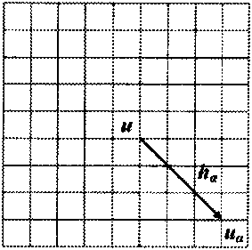
[0113] figure 1 is a two-dimensional data template composed of 9×9 pixels, u α by center u and 80 vectors h α determined, figure 2 is a three-dimensional data template composed of 3×3×3 nodes, and the center point u of the template is represented in blue.

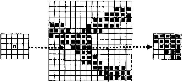
[0114] image 3 It is the process of obtaining a data event when scanning a training image (15×15) with a data template (5×5).

[0115] Figure 4 for use figure 1 The 2D data event captured by the data template. Figure 5 for use figure 2 The 3D data event captured by the data template, the colored nodes in the data event represent the known data. Nodes with the same color have the same state value.

[0116] Figure 6 Represents a filter of 15×15 pixels. The weights of the pixels corresponding to each position are shown in the status bar. Apply the filter to the pattern to obtain the "filter scor...


PUM


Abstract

The invention discloses an image simulation method based on a continuous multiple-point geostatistics method, soft data and hard data. For the prediction simulation of permeability images, soft data and hard data are comprehensively utilized to provide a method simulating permeability distribution by using the continuous multiple-point geostatistics method so as to obtain a simulation result similar to the structure characteristics of training images. Compared with the condition that only hard data is used and condition data is not provided, the invention has the highest simulation precision when using soft data and hard data and has minimum CPU time and memory consumption. Compared with the two-point geostatistics method, the continuous MPS method can simulate permeability images more accurately, so that the invention can be widely applied to the application development fields, such as geothermal energy, oil and natural gas fields, coal bed gas and the like.

Description

technical field [0001] The invention relates to an image simulation method based on continuous multi-point geostatistical method and soft and hard data. Background technique [0002] Permeability is closely related to the internal structure of rocks and formations, and it is an important parameter to characterize the internal fracture network of rocks and formations. Therefore, it is of great significance to understand the distribution characteristics of formation permeability for the development of geothermal energy, oil and gas fields and coalbed methane. Since geostatistics can perform reservoir characterization and modeling, it can simulate and predict the distribution characteristics of variable values ​​in unknown areas. The traditional two-point geostatistics is mainly used in two aspects in reservoir modeling: first, applying various kriging methods to establish deterministic models; second, applying various stochastic modeling methods to establish predictable model...

Claims


Application Information

Patent Timeline
Patent Type & Authority Applications(China)
IPC IPC(8): G01V1/30
Inventor 杜奕张挺
Owner SHANGHAI SECOND POLYTECHNIC UNIVERSITY
Why Eureka
Try Eureka