
System and method for layering population sample survey sample

A population and sample technology, applied in the field of geographic information system and demography, can solve problems such as the population factor stratification model and sample area selection method that have not been proposed

Inactive Publication Date: 2010-05-19
INST OF GEOGRAPHICAL SCI & NATURAL RESOURCE RES CAS
View PDF3 Cites 14 Cited by
  • Summary
  • Abstract
  • Description
  • Claims
  • Application Information

AI Technical Summary

Problems solved by technology

Chinese patent application number 200810104287.7 provides the "Sandwich Model Method for High-Efficiency Spatial Sampling Survey", although spatial elements have been added, there is still no hierarchical model of population factors and a method for sample area selection

Method used


Image

  • System and method for layering population sample survey sample
  • System and method for layering population sample survey sample
  • System and method for layering population sample survey sample

Examples


specific Embodiment approach

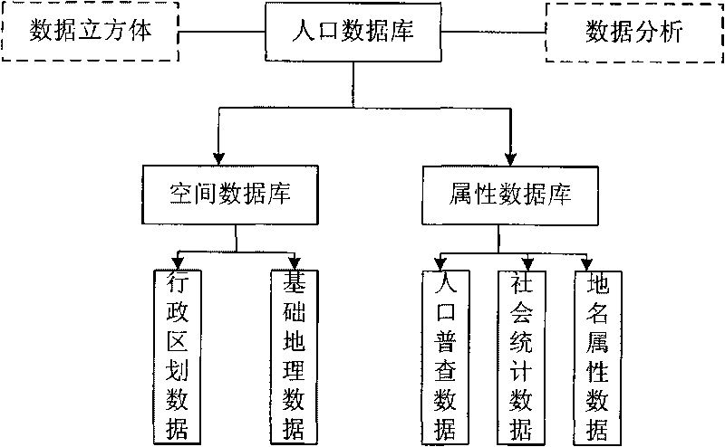
[0059] First, a population database is constructed through the population database construction module 10, including data collection, data preprocessing, database design and other database building procedures. The population database building module uses a reasonable structure to process, summarize and organize scattered databases to obtain an integrated global information database, including multiple databases such as space and attributes. Preprocess the collected basic geographic data and remote sensing data to obtain the data required by the system, such as slope, aspect, etc. In addition, because the original base map and raster data use different projections, coordinate systems and other information, in the data prediction During processing, unified management of its projected coordinate system is carried out. Then use Access to design the population database, and the present invention constitutes the three-dimensional coordinate system of the cube with characteristic dime...


PUM


Abstract

The invention discloses a system and a method for layering a population sample survey sample. The system comprises a population database building module, a population space distribution comprehensive weighting value acquiring module, an index normalizing treatment module, a layering model building module and a sample extracting module, wherein the population database building module is used for pre-processing disperse databases with the system to form an integrated global information base so as to provide data support; the population space distribution comprehensive weighting value acquiring module is used for building a population space distribution comprehensive weighting value calculating module so as to acquire a population space distribution comprehensive weighting value in each area; the index normalizing treatment module is used for normalizing quantitative index data so as to build an area factor population coefficient surface; the layering model building module is used for building a population sample survey layering module according to a set layering principle; and the sample extracting module is used for extracting the sample from the population sample survey layering module.

Description

Technical field [0001] The present invention relates to the technical fields of geographic information systems and demographics, in particular to a sample stratification system and method for population sampling surveys based on geographic information technology. Background technique [0002] Stratified sampling is also called type sampling or classification sampling. Stratified sampling is to first stratify the overall unit according to a certain mark, and then select a number of sample units in each layer according to the random principle, and the sample units drawn from each layer constitute the total sample. [0003] Stratified sampling provides a great help for improving the effectiveness of sampling and obtaining higher data accuracy. The stratified method for population sampling surveys is particularly important. In recent years, although the rapid development of geographic information technology and computer technology has provided new technical means for the design and ma...

Claims


Application Information

Patent Timeline
IPC IPC(8): G06F17/30
Inventor 王英杰余卓渊孔中哲
Owner INST OF GEOGRAPHICAL SCI & NATURAL RESOURCE RES CAS
Learn More