Integration method of multi-satellite heterogeneous remote sensing data based on SOA architecture

A remote sensing data and remote sensing technology, applied in the direction of electrical digital data processing, special data processing applications, instruments, etc., can solve the problems of high cost, heavy workload at the data receiving end, high data receiving end, etc., and achieve good results, fast and reliable data The effect of the service

Active Publication Date: 2010-03-10
SPACE STAR TECH CO LTD
View PDF2 Cites 5 Cited by
  • Summary
  • Abstract
  • Description
  • Claims
  • Application Information

AI Technical Summary

Problems solved by technology

This patent only provides a general solution for heterogeneous data integration. This method will make the data receiving end have a heavy workload, and the data receiving end is relatively high and the cost is high.

Method used


Image

  • Integration method of multi-satellite heterogeneous remote sensing data based on SOA architecture
  • Integration method of multi-satellite heterogeneous remote sensing data based on SOA architecture
  • Integration method of multi-satellite heterogeneous remote sensing data based on SOA architecture

Examples


Embodiment Construction

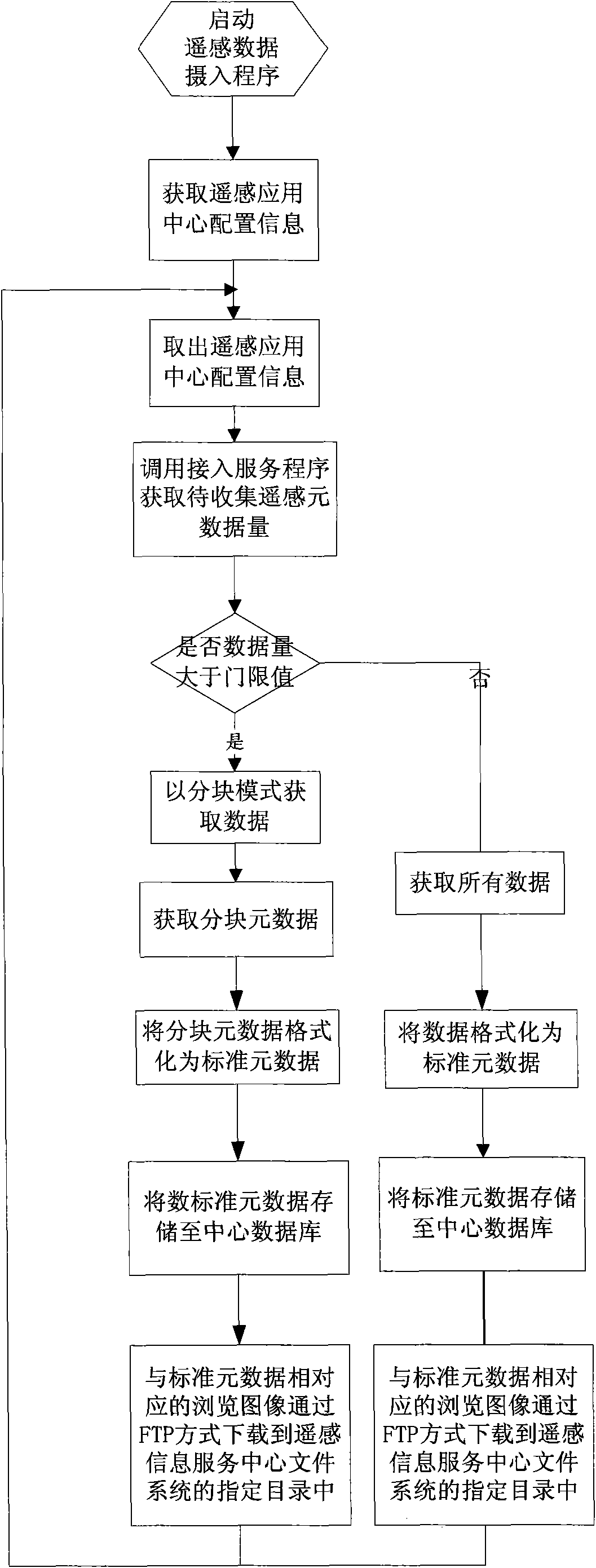
[0021] The present invention will be further described below in conjunction with accompanying drawing.

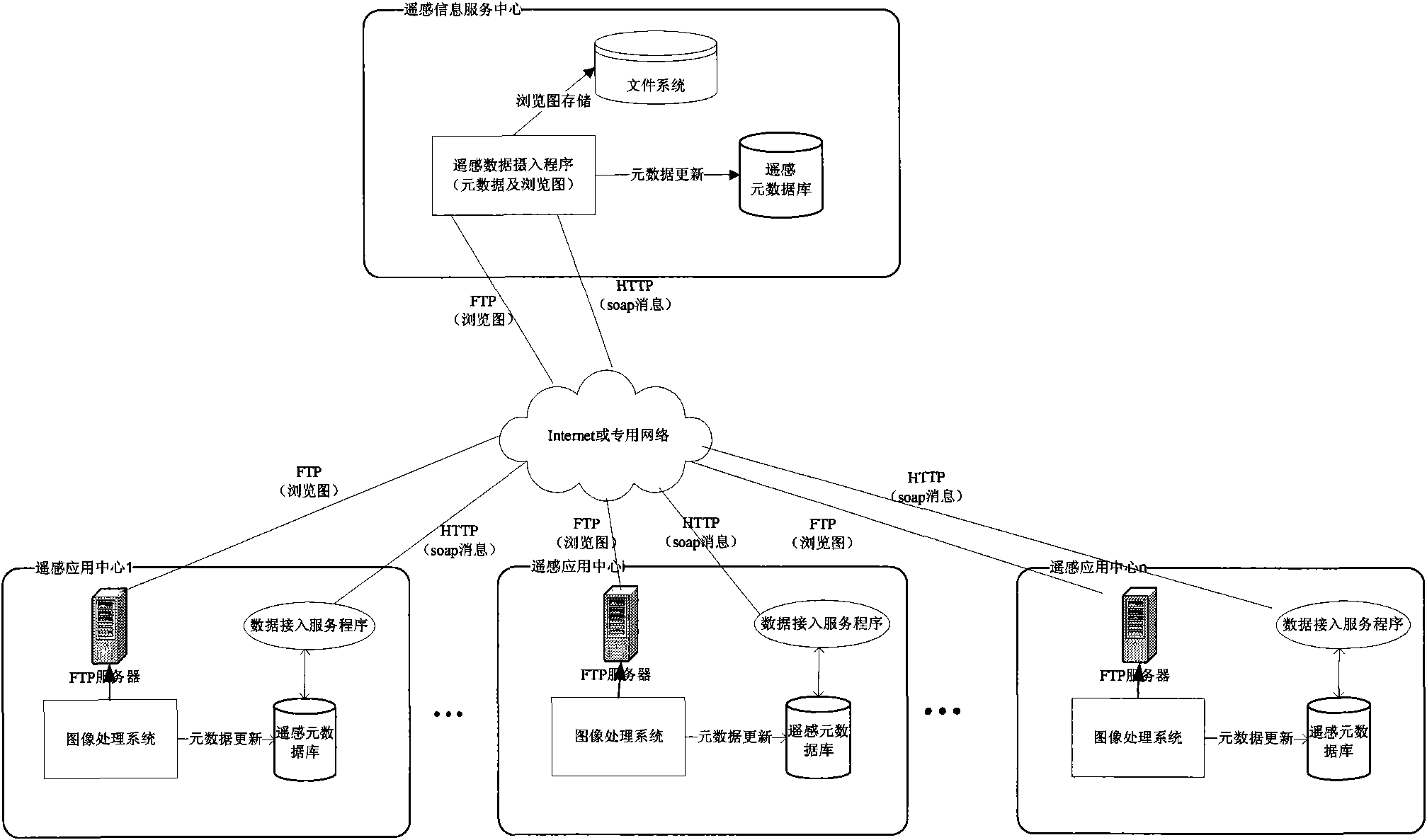
[0022] The system architecture based on the present invention is as figure 1 As shown, it includes a remote sensing information service center and multiple remote sensing application centers. The remote sensing information service center includes remote sensing data intake programs, file systems and metadata databases. Each remote sensing application center includes image processing systems, data access service programs , remote sensing metadata database and FTP server.

[0023] The remote sensing data intake program is configurable, and its operation period can be changed according to the update frequency and amount of the actual remote sensing metadata in the remote sensing application center, and the information of the data access service program can be changed as the access The remote sensing application center can be changed, and the data access service program can be...


PUM


Abstract

The invention relates to an integration method of multi-satellite heterogeneous remote sensing data based on an SOA architecture. In the integration method, a data access service program is established in a remote sensing application center; a remote sensing data capture program of a remote sensing information service center calls the data access service program; the data access service program acquires remote sensing information metadata from the local, converts the local remote sensing information metadata into uniform standard remote sensing metadata and then responds to the remote sensingdata capture program; and the remote sensing data capture program updates the acquired metadata into a remote sensing metadatabase of the remote sensing information service center, acquires a view image and stores the view image into a local file system simultaneously, therefore, the dynamic fast update of the remote sensing information metadata and the view image can be completed, and the acquisition of remote sensing metadata of a ground system can be realized. The method solves the problems that the traditional remote sensing application centers are separated from each other and can not provide shared heterogeneous remote sensing data.

Description

technical field [0001] The invention relates to a multi-satellite heterogeneous remote sensing data integration method based on SOA architecture, which is applied to a domestic multi-satellite remote sensing data user service system. Background technique [0002] With the development of my country's space technology, satellite remote sensing technology has been applied to more and more industries, and various remote sensing satellite application centers have been gradually established to provide data services to external users. On the other hand, users cannot obtain all the remote sensing data they need from an isolated application system at the same time. How to share these heterogeneous remote sensing data so that users can quickly and conveniently find these data is the key to solving this contradiction. One way to solve this problem is to integrate the data of various remote sensing satellite application centers and quickly provide services to external users in the same ...

Claims


Application Information

Patent Timeline
Patent Type & Authority Applications(China)
IPC IPC(8): G06F17/30H04L29/08
Inventor 史志敏王扬李璇李霖
Owner SPACE STAR TECH CO LTD
Why Eureka
Try Eureka