
Method for improving attitude determination precision of airborne laser radar

An airborne laser radar and attitude determination technology, which is applied in the direction of re-radiation of electromagnetic waves, utilization of re-radiation, measurement devices, etc. It can achieve broad application prospects, reduce system costs, and improve the accuracy of attitude determination.

Inactive Publication Date: 2009-12-23
BEIHANG UNIV
View PDF1 Cites 38 Cited by
  • Summary
  • Abstract
  • Description
  • Claims
  • Application Information

AI Technical Summary

Problems solved by technology

On the other hand, the limitation of the load capacity of light and small aircraft also limits the storage capacity of the storage device, which makes the aerial photography cycle of aerial photography images not too small
At the same time, a too small aerial photography period will lead to a rapid increase in the amount of data processing, which not only increases the difficulty of data processing, but also is not conducive to the timely acquisition of lidar remote sensing images.

Method used


Image

  • Method for improving attitude determination precision of airborne laser radar
  • Method for improving attitude determination precision of airborne laser radar
  • Method for improving attitude determination precision of airborne laser radar

Examples


Embodiment Construction

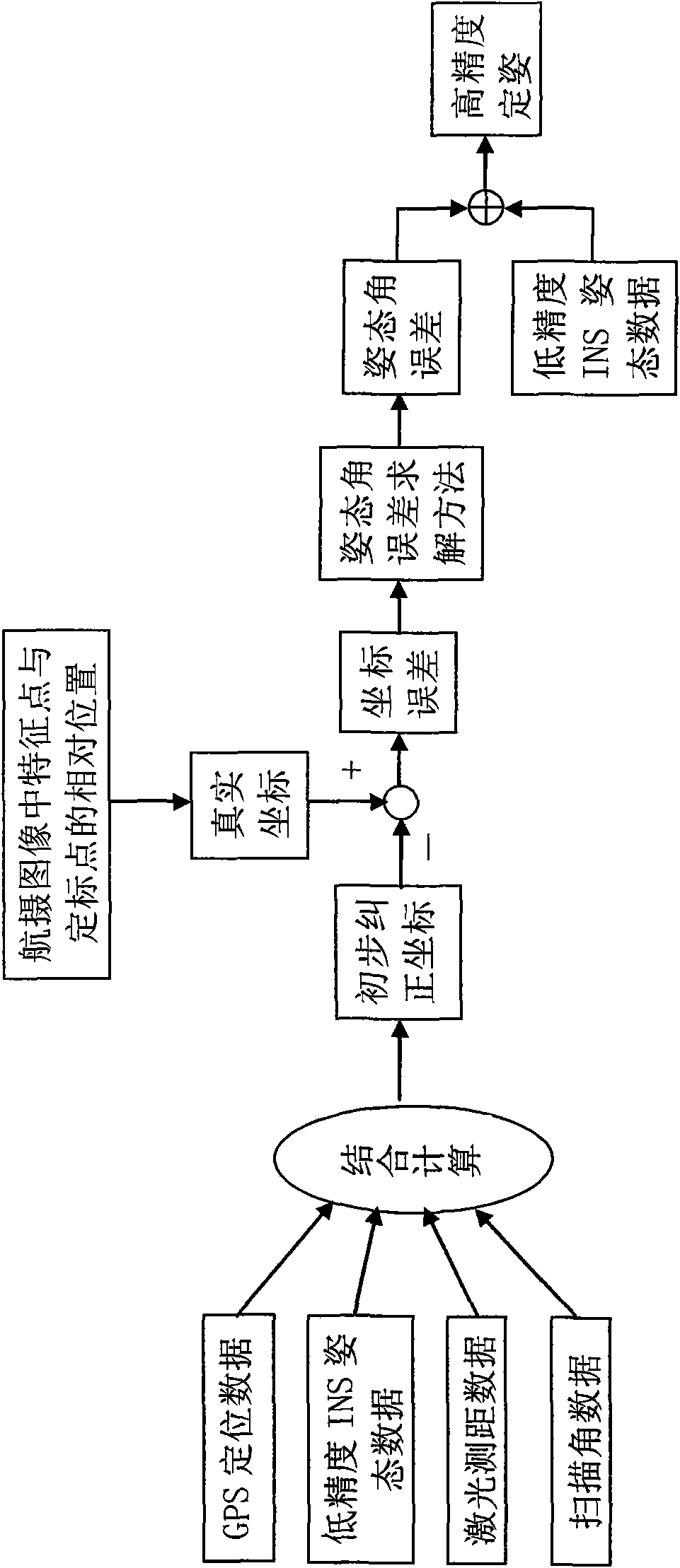
[0022] The specific implementation manners of the present invention will be described in detail below in conjunction with the accompanying drawings. The principle diagram of the method for improving the accuracy of airborne laser radar attitude determination in the present invention is as follows figure 1 As shown, two feature points are selected in the scan area where each attitude angle remains constant. In the reference image containing calibration points (two calibration points are set on the ground in advance, and their coordinates in the X direction and Y direction of the earth coordinate system are known), according to the relative relationship between the feature point and the calibration point on the image The "true coordinates" of the feature points in the X and Y directions of the geodetic coordinate system can be obtained by the position and the magnification of the camera. The accuracy is affected by the resolution of the aerial image and the effect of image disto...


PUM


Abstract

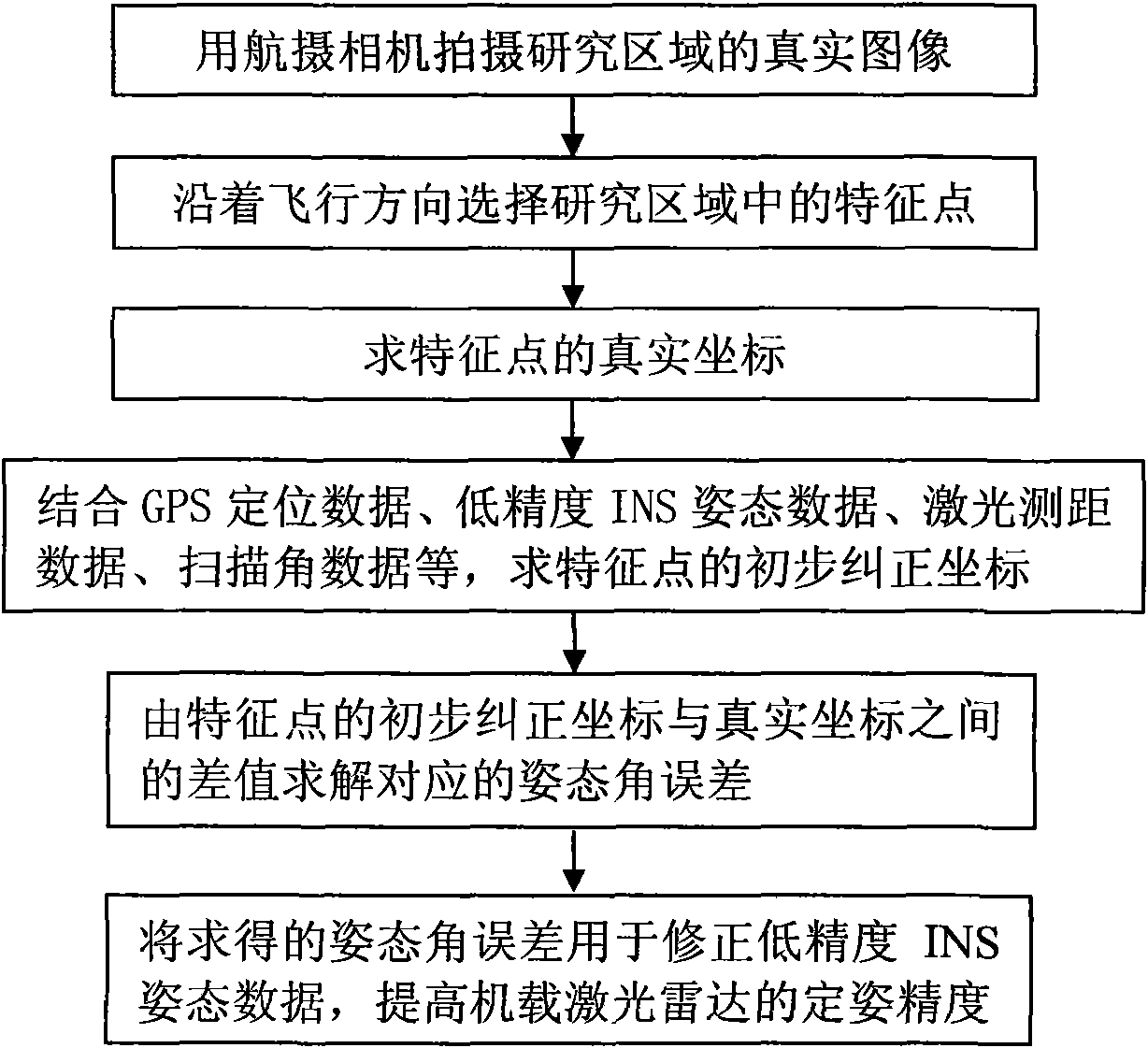
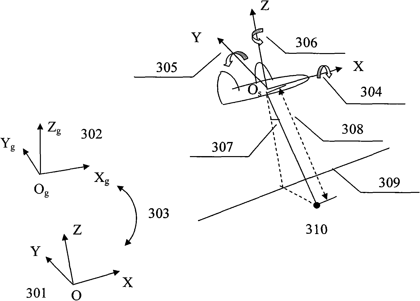
The invention discloses a method for improving attitude determination precision of an airborne laser radar by solving three attitude angle errors through two-dimensional coordinate errors of feature points on a geodetic coordinate system under the condition of selecting an INS with low cost and low precision. The method is characterized in that the method combines three-dimensional initial correction coordinates of GPS positioning data, INS attitude determination data, laser distance measurement data, scanning angle data and other feature points on the geodetic coordinate system, solves the attitude angle errors by differences between the initial correction coordinates of the feature points in the two-dimensional direction of the geodetic coordinate system and real coordinates according to the mapping relation between the coordinate errors of laser footprints on the geodetic coordinate system and the attitude angle errors, and utilizes the solved attitude angle errors to amend the INS attitude data with low precision, thereby improving the attitude determination precision of the airborne laser radar. The method can greatly reduce system cost and amend the attitude angle errors with high frequency, thereby being applicable to the situations of platform attitude frequent change in light and small aerial remote sensing applications.

Description

technical field [0001] The invention relates to the field of remote sensing and earth observation, and mainly relates to a method for improving the attitude determination accuracy of an airborne laser radar. Background technique [0002] Airborne lidar is widely used in terrain surveying and mapping, ocean bathymetry, atmospheric environment monitoring, ecosystem measurement, military and national defense due to its advantages of all-weather work, flexible operation, low cost, convenient operation, high operation efficiency, and short mapping cycle. and other fields. [0003] With the development of Global Positioning System (Global Position System, GPS), Inertial Navigation System (Inertial Navigation System, INS), and laser ranging technology, the positioning accuracy and imaging accuracy of airborne lidar have been greatly improved. In particular, the application of differential GPS technology has improved the positioning accuracy of GPS from meter level to centimeter le...

Claims


Application Information

Patent Timeline
Patent Type & Authority Applications(China)
IPC IPC(8): G01S7/497G01S17/00G01C11/00
Inventor 徐立军周婉露李小路王建军
Owner BEIHANG UNIV
Learn More