Region quasi-geoid refining method based on CQG2000

A geoid and GPS leveling technology, used in height/level measurement, measuring devices, instruments, etc., can solve the problems of complex measurement process and high measurement cost, and achieve the effects of huge social benefits, great difficulty and long cycle.

Inactive Publication Date: 2009-07-29
CHANGAN UNIV
View PDF0 Cites 15 Cited by
  • Summary
  • Abstract
  • Description
  • Claims
  • Application Information

AI Technical Summary

Problems solved by technology

[0005] The technical problem to be solved by the present invention is to provide a CQG2000-based regional quasi-geoid refinement method for the deficiencies in the prior art. The problem of level fitting defects caused by the inability to obtain gravity data during level refinement can overcome the practical problems of complex measurement process and high measurement cost when using gravity data refinement

Method used


Image

  • Region quasi-geoid refining method based on CQG2000
  • Region quasi-geoid refining method based on CQG2000
  • Region quasi-geoid refining method based on CQG2000

Examples


Embodiment 1

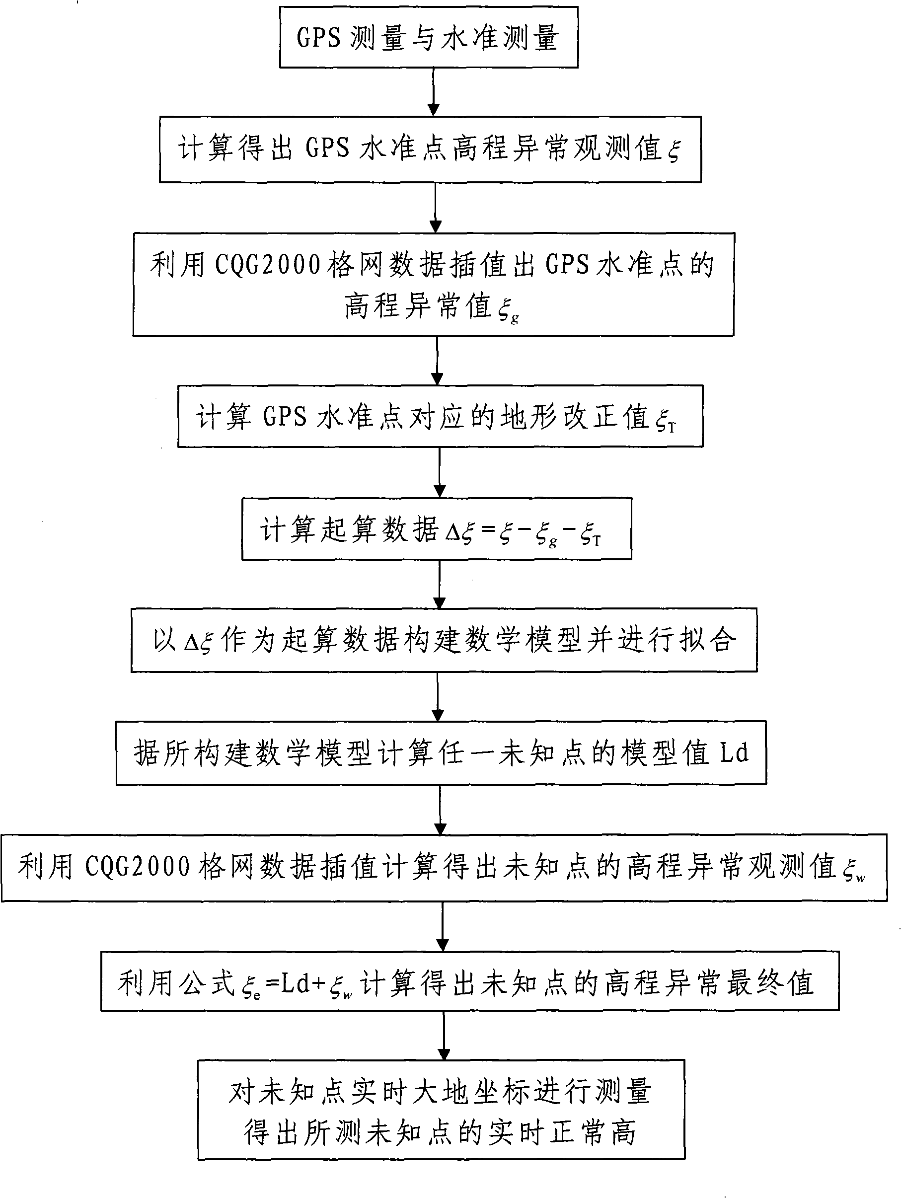
[0028] Such as figure 1 As shown, the CQG2000-based region-like geoid refinement method of the present invention comprises the following steps:

[0029] Step 1, constructing the regional quasi-geoid model of the area to be measured, which mainly includes the following steps:

[0030] (a) Remove and calculate the starting data value Δξ of the regional quasi-geoid model to be constructed:

[0031] First of all, the regional GPS leveling network of the area to be measured is laid out, GPS receivers and leveling instruments are used to carry out GPS measurement and leveling measurement on the area to be measured at the same time, and the GPS observation data and leveling measurement data are obtained, and corresponding calculations are obtained Height anomaly observation value ξ of GPS benchmarking point. In this embodiment, the area to be measured is a plain area with little terrain fluctuation.

[0032] That is to say, in the early stage of refinement, in accordance with the "N...

Embodiment 2

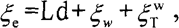
[0049] Such as figure 2 As shown, the area to be measured is a mountainous or hilly area with little terrain undulation. The method for refining the geoid-like area based on CQG2000 according to the present invention has the same steps as in Embodiment 1, the main difference is that it needs to calculate The terrain correction model mainly includes the following steps:

[0050] (a) Remove and calculate the starting data value Δξ of the regional quasi-geoid model to be constructed:

[0051] First of all, the regional GPS leveling network of the area to be measured is laid out, GPS receivers and leveling instruments are used to carry out GPS measurement and leveling measurement on the area to be measured at the same time, and the GPS observation data and leveling measurement data are obtained, and corresponding calculations are obtained Height anomaly observation value ξ of GPS benchmarking point.

[0052] In this embodiment, there are m GPS horizontal coincidence points and ...


PUM


Abstract

The invention discloses a region quasi-geoid refining method based on CQG2000, including the followings: step one, the CQG2000 is used as a platform, and GPS leveling data is used for determining the quasi-geoid model of the region to be measured according to remove-fit-restore method; step two, GPS system is used for obtaining the real-time geodetical coordinates of any unknown point in the region to be measured, and measured data are transmitted to an arithmetic and control unit that uses the constructed region quasi-geoid model to convert the measured GPS geodetic height of the known point into normal height, i.e., leveling height, in real time. The method is simple and convenient to be carried out, the measured data are accurate and reliable, and the measurement speed is quick, thereby being capable of efficiently solving the problem of geoid fitting defect caused by no gravity data obtained when the quasi-geoid is refined and the problems of complicated measuring processes and big measuring cost when gravity data is used for refining, greatly improving the precision and resolution factor of quasi-geoid and having very high use value.

Description

technical field [0001] The invention relates to the technical field of research on the earth's gravity field, in particular to a CQG2000-based refinement method for a regional quasi-geoid. Background technique [0002] With the wide application of GPS positioning technology, people have been able to -7 to 10 -9 On the order of accuracy, the plane position of the measured point can be obtained simply and economically, but the elevation (altitude) of the point has not been solved with the corresponding accuracy. The reason is that although GPS can give high-precision geodetic height, there is no (similar) geoid model with corresponding accuracy and high resolution, so that the accuracy is seriously lost in the conversion from GPS geodetic height to GPS altitude. For this reason, the international geodesy community, including my country, is currently working on the establishment of regional high-resolution and high-precision quasi-geoids or geoids. [0003] The (similar) geo...

Claims


Application Information

Patent Timeline
Patent Type & Authority Applications(China)
IPC IPC(8): G01C5/00
Inventor 张勤刘站科黄观文王利程传录
Owner CHANGAN UNIV
Why Eureka
Try Eureka