Star base reinforced satellite positioning and GPS compatible software receiver system

A software receiver and satellite positioning technology, which is applied in the field of signal receiving and processing for navigation and positioning, can solve the problems of insufficient positioning accuracy and reliability, singleness, etc., and achieve the effect of improving accuracy and reliability, and improving positioning accuracy

Inactive Publication Date: 2009-04-15
SHANGHAI INST OF TECHNICAL PHYSICS - CHINESE ACAD OF SCI
View PDF0 Cites 23 Cited by
  • Summary
  • Abstract
  • Description
  • Claims
  • Application Information

AI Technical Summary

Problems solved by technology

[0004] In recent years, influenced by the thought of software radio, more and more GPS receivers are implemented by software methods, but GPS software receivers can only process a single GPS signal, which has great shortcomings in positioning accuracy and reliability

Method used


Image

  • Star base reinforced satellite positioning and GPS compatible software receiver system
  • Star base reinforced satellite positioning and GPS compatible software receiver system
  • Star base reinforced satellite positioning and GPS compatible software receiver system

Examples


Embodiment Construction

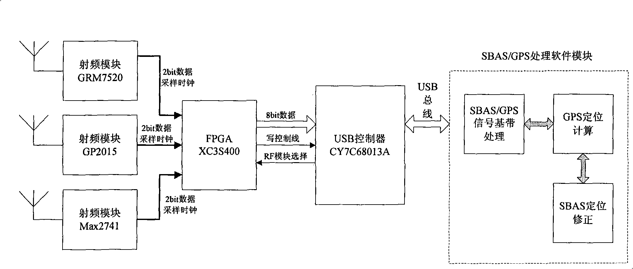
[0027] The present invention will be further described below in conjunction with the accompanying drawings and implementation examples. The invention uses self-developed and designed GPS radio frequency hardware module and SBAS+GPS processing software running on the computer platform to realize simultaneous processing of signals in two modes of SBAS and GPS.

[0028] GPS radio frequency hardware module of the present invention is as attached figure 1 As shown, SBAS and GPS signals enter the radio frequency front-end (RF) module through the same antenna, undergo a series of amplification, filtering and down-conversion processing, and convert them into 2-bit intermediate frequency digital signals through A / D. Under the control of the FPGA, the intermediate frequency digital signal is collected into the internal FIFO of the FPGA and stored in a certain length of data blocks in a ping-pong manner. Finally, through the USB controller, transfer to the computer in blocks. The hard...


PUM


Abstract

The invention discloses a multi-mode software receiver system in which SBAS is compatible with GPS, belonging to the field of satellite positioning and navigation. The software receiver consists of a GPS radio frequency hardware module and a processing software module operating on a computer platform. The invention mainly solves the problem that the SBAS / GP signal is processed on the software framework of the computer platform, especially the problem that the SBAS signal is used for amending the positioning result. Compared with a general positioning software receiver, the software receiver of the invention can simultaneously process the signals of SBAS and GPS modes, thereby obviously improving positioning accuracy, reliability and integrity of a single GPS positioning system.

Description

Technical field: [0001] The invention belongs to the technical field of signal receiving and processing for navigation and positioning, and in particular relates to the system design of a multi-mode software receiver compatible with SBAS (satellite-based augmentation system) and GPS (global positioning system). It is applicable to ground, near space, airborne / Spaceborne and other positioning signal reception processing, analysis and application development. Background technique: [0002] In order to enhance the navigation performance of existing GPS and GLONASS systems, the US Federal Aviation Administration (FAA), Europe and Japan proposed three kinds of SBAS: WAAS, EGNOS and MSAS systems. SBAS (Satellite Based Augmentation System) is a modern wide-area differential augmentation system established using geostationary orbit satellites. SBAS broadcasts ranging, wide-area differential and satellite integrity information through geostationary satellites, which can significant...

Claims


Application Information

Patent Timeline
Patent Type & Authority Applications(China)
IPC IPC(8): G01S1/04G01S5/02G01S5/14
Inventor 张雷邓江平王建宇戴宁
Owner SHANGHAI INST OF TECHNICAL PHYSICS - CHINESE ACAD OF SCI
Why Eureka
Try Eureka