
Unmanned aerial vehicle radio-altimeter height and lifting speed self-correcting method

A technology of radio altimeter and lifting speed, which is applied in the direction of height or depth control, measuring devices, instruments, etc., can solve the problems of information incomparability, height difference, wrong results, etc., to improve reliability, eliminate system errors, high The effect of control precision

Inactive Publication Date: 2008-09-24
BEIHANG UNIV
View PDF0 Cites 28 Cited by
  • Summary
  • Abstract
  • Description
  • Claims
  • Application Information

AI Technical Summary

Problems solved by technology

During the flight of the aircraft, if there is a large attitude angle, the altitude output by different altimeters will be quite different. At this time, if the altimeter information is managed with redundancy based on the altimeter measurement accuracy and other criteria, because The measurement points of these measurements themselves are not the same, the information is not comparable, and wrong results are likely to appear after voting

Method used


Image

  • Unmanned aerial vehicle radio-altimeter height and lifting speed self-correcting method
  • Unmanned aerial vehicle radio-altimeter height and lifting speed self-correcting method
  • Unmanned aerial vehicle radio-altimeter height and lifting speed self-correcting method

Examples


Embodiment Construction

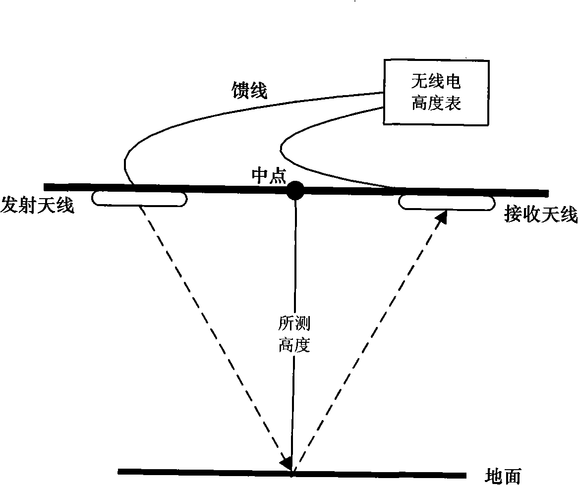
[0027] Below in conjunction with accompanying drawing, the radio altimeter height of the present invention and the automatic correction method of ascending and descending speed will be further described.

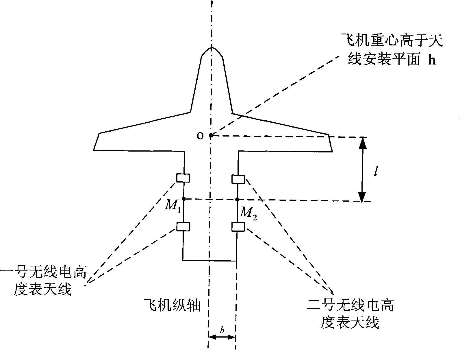
[0028] Step 1: According to the altitude H measured by each radio altimeter on the aircraft cli and lifting speed Calculate the height H at the center of gravity of the aircraft zxi and lifting speed (i=1, 2, . . . n).

[0029] Assuming that the number of radio altimeters is n, according to the height H measured by each radio altimeter cli and lifting speed Calculate the height H at the center of gravity of the aircraft zxi and lifting speed i represents the number of radio altimeters, (i=1, 2,...n).

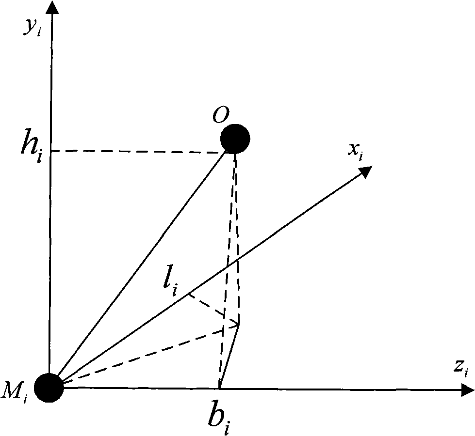
[0030] Let the midpoint of the connection line connecting a pair of transceiver antenna installation positions of a certain radio altimeter be M i point to M i Point is the origin to establish a Cartesian coordinate system M i x i the y i z i ,Such as figure...


PUM


Abstract

The invention discloses an automatic method to correct height and lifting speed of a radio altimeter for unmanned aerial vehicle. The correcting method is as follows: the height Hcli and the lifting speed cli obtained from each radio altimeter on the aircraft are revolved to get the height Hzxi and the lifting speed«Úzxi at the center of gravity of the aircraft, and the signal-voting results of the height Hzxi and the lifting speed«Úzxi at the center of gravity of the aircraft are corrected through a system deviation Delta H after signal-voting. The system error of the radio altimeter in the course of using is eliminated through the method. The correcting method of the invention is applied in the automatic flight control of the unmanned aerial vehicle to obtain higher control precision, which is beneficial for flight safety, and provides a premise for radio altitude and signal redundancy management of the lifting speed of unmanned aerial vehicle with configuration of a plurality of radio altimeter, and increases system reliability.

Description

technical field [0001] The invention relates to the field of unmanned aerial vehicle flight control, in particular to a method for automatically correcting the altitude and lifting speed of an unmanned aerial vehicle radio altimeter. Background technique [0002] The radio altimeter is an airborne radio device that measures the vertical distance from the aircraft to the ground, and is one of the important aircraft instruments. The aircraft transmits radio waves to the ground, and after being reflected by the ground, it is received by the aircraft receiver. The time it takes for the radio waves to travel twice the flight altitude is equal to the quotient of the twice the flight altitude divided by the propagation speed of the radio wave. The speed of electric wave propagation is a constant value, as long as this period of time is measured, the flight height can be obtained. The radio altimeter measures the rate of change of the altitude, that is, the ascending and descending...

Claims


Application Information

Patent Timeline
Patent Type & Authority Applications(China)
IPC IPC(8): G01C21/20G01C21/00G01C25/00G05D1/04
Inventor 王宏伦方晓星王金提
Owner BEIHANG UNIV
Learn More