Navigation method used for navigation in small region

A navigation method and technology for small areas, applied in the field of navigation, can solve problems such as high cost and environmental restrictions, and achieve the effect of simple network construction and low cost

Inactive Publication Date: 2008-01-02
AIGO DIGITAL TECHNOLOGY CO LTD
View PDF0 Cites 18 Cited by
  • Summary
  • Abstract
  • Description
  • Claims
  • Application Information

AI Technical Summary

Problems solved by technology

[0005] 2. Environmental restrictions, GPS communicates with the stand-alone through the signal transmitted by the satellite, obstacles, buildings, trees will block the satellite signal, so for indoor positioning and navigation, GPS is useless
[0006] 3. High cost

Method used


Image

  • Navigation method used for navigation in small region
  • Navigation method used for navigation in small region
  • Navigation method used for navigation in small region

Examples


Embodiment Construction

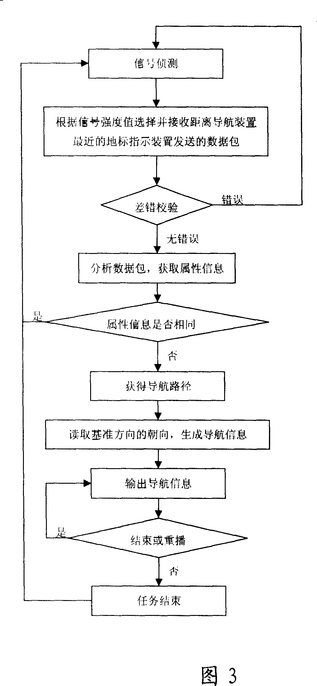
[0022] In order to further explain the technical means and effects of the present invention to achieve the intended purpose of the invention, the navigation method proposed according to the present invention, its specific implementation, features and effects will be described in detail below in conjunction with the accompanying drawings and preferred embodiments As later.

[0023] The navigation method of the present invention locates the user's location through the signal transmission between the navigation device and the landmark indicating device arranged at a fixed position, and the processing module of the navigation device can according to the destination information input by the user, the electronic map stored in the storage unit of the navigation device and the user's location to obtain a navigation path, and output and display the navigation path as navigation information. In addition, the navigation device of the present invention can also be provided with a compass ...


PUM


Abstract

The invention relates to a navigation method in area which includes: navigation device detects signal for pilotage indicating device, and receives data package sent by pilotage indicating device nearest to the navigation device; the navigation device checks and analyzes the data package to obtain property information of pilotage indicating device stored in the data package; based on property information of pilotage indicating device nearest to the navigation device, destination and electronic map, the process module obtains position of user and navigation path from position of user to destination; obtains current orientation of user, and the process module generates heading direction of current position along navigation path, and compares the heading direction of navigation path with the current orientation of user to generate heading direction of user when user is in current orientation, so effect of navigation in area can be realized.

Description

【Technical field】 [0001] The invention relates to a navigation method used for navigation in a small area, in particular to a method for positioning and navigation using signal transmission between a navigation device and a landmark indicating device set at a fixed position. 【Background technique】 [0002] The current positioning and navigation technology generally adopts the Global Positioning System (GFS, Global Positioning System), which is a global positioning, navigation and timing system composed of 24 satellites launched by the US Department of Defense. Fly around the Earth in six orbits of 20,000 kilometers. There are four satellites in each orbit, and the signals from the four satellites can be received at any point on the earth at any time at the same time, and the space orbit information transmitted by the satellites covers the entire earth's surface. GPS uses navigation satellites to measure time and distance, so that users anywhere on the earth can calculate th...

Claims


Application Information

Patent Timeline
Patent Type & Authority Applications(China)
IPC IPC(8): G01C21/26G01C21/34G01C21/20G01S5/14
Inventor 任学宁陈杰朱丽娟
Owner AIGO DIGITAL TECHNOLOGY CO LTD
Why Eureka
Try Eureka