
Single satellite remote sensing image small target super resolution ratio reconstruction method

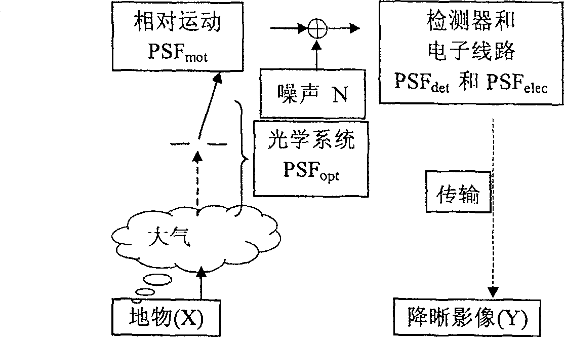
A satellite remote sensing image and super-resolution reconstruction technology, which is applied in the field of satellite remote sensing image, can solve the problems such as the lack of a unified objective evaluation standard for the quality evaluation of the reconstructed image, the adaptability and robustness of the reconstruction algorithm, etc., and achieve the goal of suppressing high-frequency noise Effects of amplification and introduction of false information, improvement of spatial resolution, and high efficiency of deblurring

Inactive Publication Date: 2009-07-08
BAINIAN JINHAI SCI & TECH
View PDF1 Cites 0 Cited by
  • Summary
  • Abstract
  • Description
  • Claims
  • Application Information

AI Technical Summary

Problems solved by technology

However, there are still many problems in the research of super-resolution image reconstruction, such as: 1. How to restore high-frequency detail information while suppressing the amplification of high-frequency noise; 2. There is still no unified objective evaluation standard for the quality evaluation of reconstructed images; 3. Effective identification method of system parameters; 4. Adaptability and robustness of reconstruction algorithm, etc.

Method used


Image

  • Single satellite remote sensing image small target super resolution ratio reconstruction method
  • Single satellite remote sensing image small target super resolution ratio reconstruction method
  • Single satellite remote sensing image small target super resolution ratio reconstruction method

Examples


Embodiment Construction

[0030]The present invention proposes to use remote sensing image linear objects, edge detection, image analysis and empirical formulas to identify the dedefinition parameters of my country's in-orbit satellite remote sensors; proposes a method based on morphological redundant wavelet transform to suppress high-frequency noise signals in the process of image reconstruction On the basis of increasing the high-frequency detail information of remote sensing images, regularization is carried out in the frequency and wavelet domains respectively, suppressing false information, and realizing super-resolution reconstruction of small targets. On the other hand, the robustness and adaptability of the reconstruction algorithm are improved. It is mainly used in satellite image military target recognition, small target detection and remote sensing image measurement.

[0031] The present invention is a method for super-resolution reconstruction of a small target in a single remote sensing ima...


PUM


Abstract

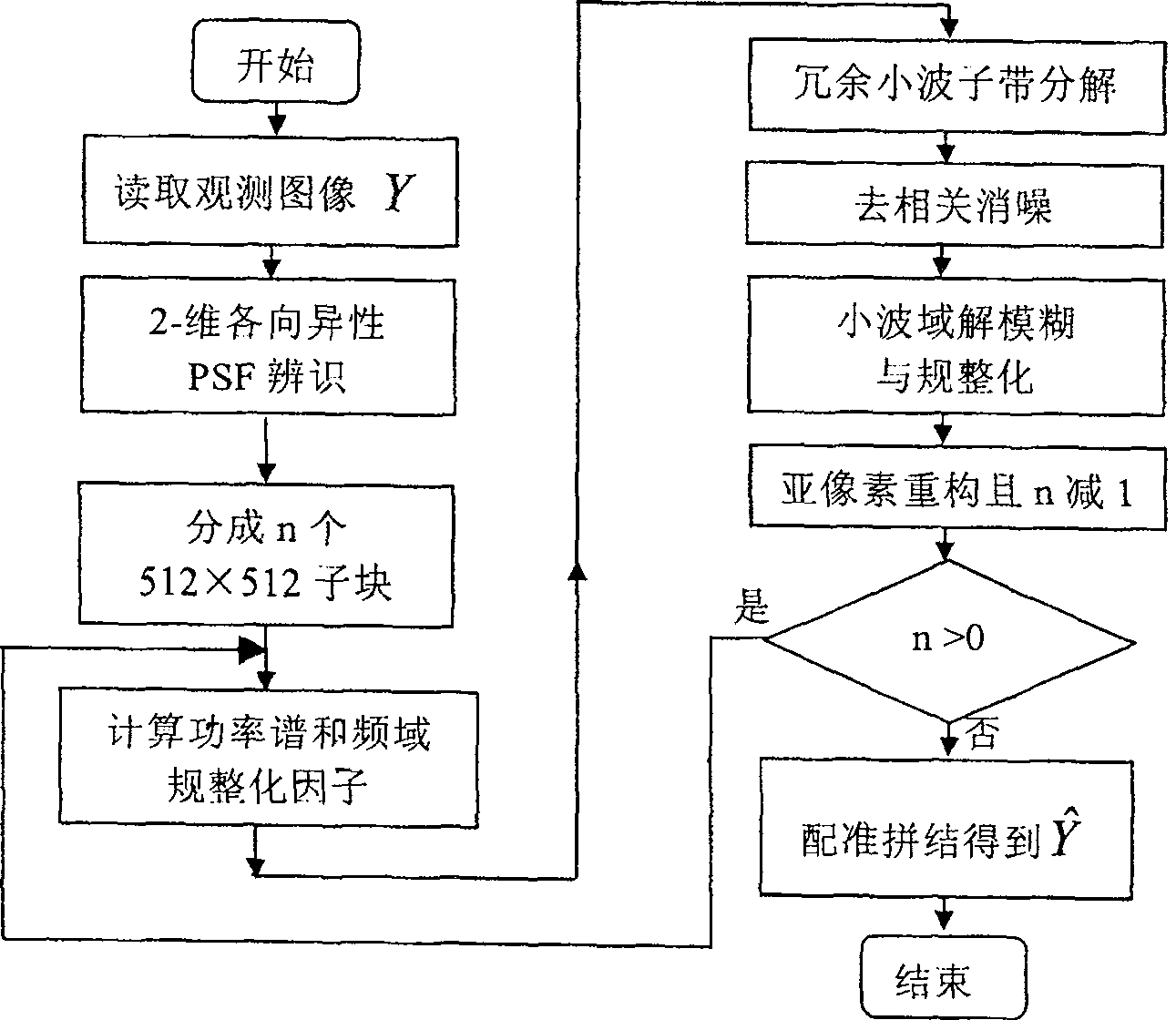
The invention is a method for super-resolution reconstruction of a small target of a single satellite remote sensing image based on the identification of on-orbit satellite dedefinition parameters, which specifically includes: establishing an on-orbit satellite remote sensing influence dedefinition model, identifying and analyzing the dedefinition parameters; estimating the signal noise of the remote sensing image Compare and calculate the regularization factor α; the reconstruction algorithm divides the remote sensing image into overlapping sub-blocks, divide and conquer, and reduce the complexity of the algorithm; the regularization of the frequency domain and the redundant wavelet domain; the de-correlation denoising operator; the establishment of a single satellite remote sensing Fast algorithm for image super-resolution image reconstruction; sub-pixel reconstruction; modulation transfer function as an objective standard for spatial resolution evaluation and image quality evaluation of remote sensing images. The invention is used in the fields of satellite image military target recognition, small target detection, remote sensing image measurement of land resources and the like. The invention has the advantages of high de-correlation and defuzzification efficiency, the spatial resolution of the remote sensing image is increased to 1.5-2 times of the original image, the SNR can be increased by 5dB, the algorithm speed is fast, and the application is wide.

Description

technical field [0001] The invention relates to the field of satellite remote sensing images, in particular to a method for super-resolution reconstruction of a small target in a single satellite remote sensing image based on the identification of in-orbit satellite resolution reduction parameters. Background technique [0002] In the process of satellite optical imaging, transmission, and acquisition of remote sensing images, due to the influence of atmospheric disturbance, defocus, and relative motion on the imaging system, the image will be degraded to varying degrees, typically aliasing, blurring, distortion, and system noise. As a result, small targets cannot be detected and identified. Super-resolution reconstruction is an algorithm for reconstructing images with better image quality and high spatial resolution from images with poorer quality and lower resolution. It is mainly used in satellite imagery military target recognition, small target detection and remote sens...

Claims


Application Information

Patent Timeline
Patent Type & Authority Patents(China)
IPC IPC(8): G01S7/48G01S17/89
Inventor 秦前清孙涛杨志高林立宇梅天灿杨杰武文波
Owner BAINIAN JINHAI SCI & TECH
Learn More