Network link for providing dynamic data layer in a geographic information system
What is Al technical title?
Al technical title is built by PatSnap Al team. It summarizes the technical point description of the patent document.
a geographic information system and network link technology, applied in the field of mapping systems, can solve the problems of limited usefulness of conventional geographic information systems in both their overall functionality and user interfa
Active Publication Date: 2011-04-26
GOOGLE LLC
View PDF73 Cites 199 Cited by
Summary
Abstract
Description
Claims
Application Information
AI Technical Summary
This helps you quickly interpret patents by identifying the three key elements:
Problems solved by technology
Method used
Benefits of technology
Problems solved by technology
Generally, conventional geographic information systems have limited usefulness in both their overall functionality and user interface.
Method used
Image
Click on the blue label to locate the original text in one second.
Reading with bidirectional positioning of images and text.
Examples
Embodiment Construction
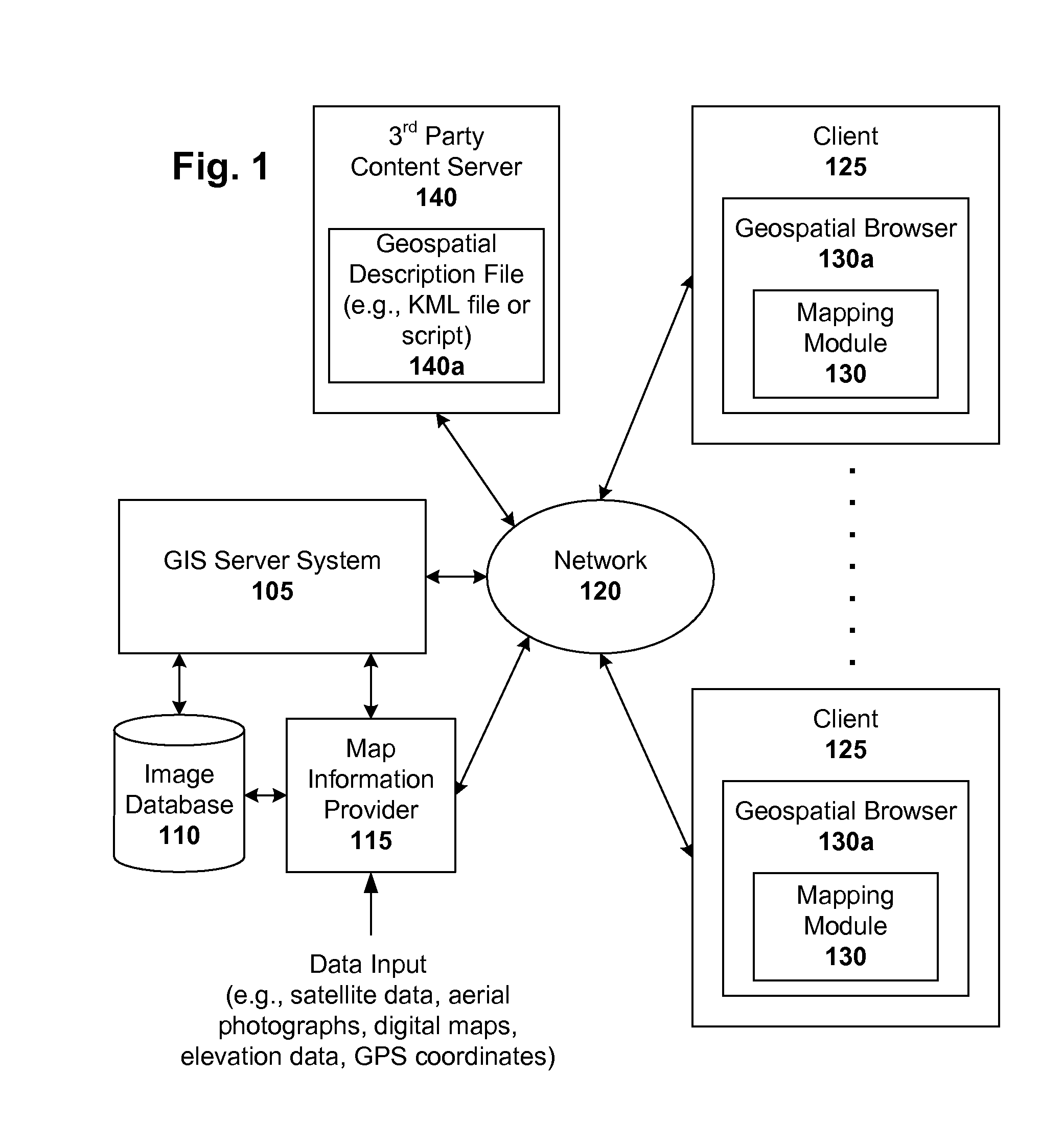
[0023]Geographic information systems (GIS) and techniques are disclosed that provide users with a greater degree of flexibility, utility, and information. The system may be a distributed geographic information system (DGIS) including multiple components the communicate with one another. For purposes of this disclosure, assume that “GIS” includes both GIS and DGIS configurations.
[0024]General Overview
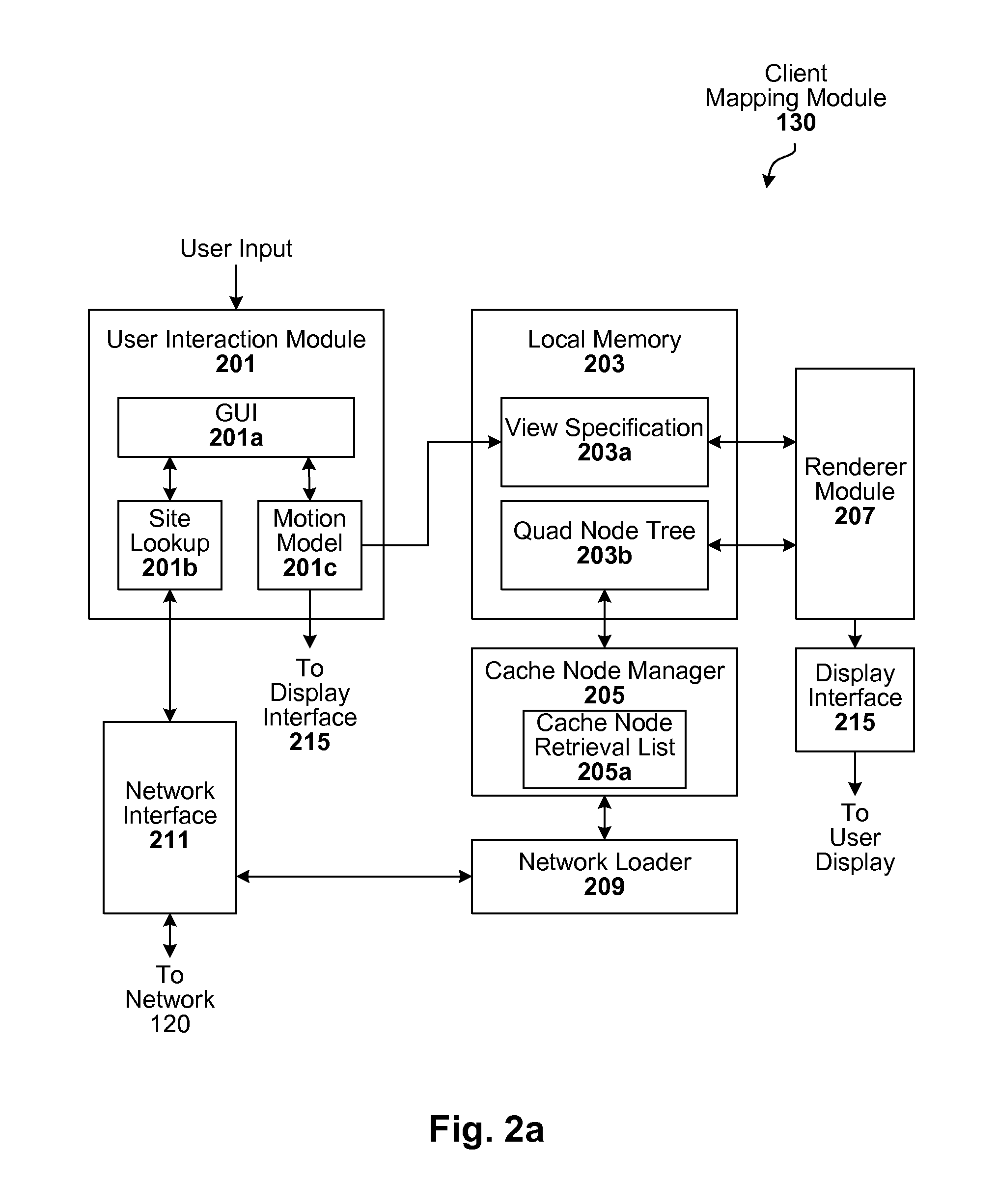
[0025]A GIS configured to carryout the techniques described herein can be implemented, for example, in a client-server architecture. Other configurations will be apparent in light of this disclosure. In accordance with one such embodiment of the present invention, client-side software operates (in conjunction with server-side software) to bring images of the Earth and other geospatial information to a user's computer so they can be seen by the user. In one example case, the client software is implemented using various software objects that are grouped in modules according to different fu...
PUM
Abstract
A markup language is provided that facilitates communication between servers and clients of an interactive geographic information system (GIS, which enables a number of GIS features, such as network links (time-based and / or view-dependent dynamic data layers), ground overlays, screen overlays, placemarks, 3D models, and stylized GIS elements, such as geometry, icons, description balloons, polygons, and labels in the viewer by which the user sees the target area. Also, “virtual tours” of user-defined paths in the context of distributed geospatial visualization is enabled. Streaming and interactive visualization of filled polygon data are also enabled thereby allowing buildings and other such features to be provided in 3D. Also, techniques for enabling ambiguous search requests in a GIS are provided.
Description
RELATED APPLICATIONS[0001]This application claims the benefit of U.S. Provisional Application No. 60 / 694,529, filed Jun. 27, 2005, titled “Intelligent Distributed Geographic Information System.” In addition, this application is related to U.S. application Ser. No. 11 / 426,681, filed Jun. 27, 2006, titled “Virtual Tour of User-Defined Paths in a Geographic Information System”. In addition, this application is related to U.S. application Ser. No. 11 / 426,686, filed Jun. 27, 2006, titled “Streaming and Interactive Visualization of Filled Polygon Data in a Geographic Information System”. In addition, this application is related to U.S. application Ser. No. 11 / 426,694, filed Jun. 27, 2006, titled “Dynamic View-Based Data Layer in a Geographic Information System”. In addition, this application is related to U.S. application Ser. No. 11 / 426,831, filed Jun. 27, 2006, titled “Markup Language for an Interactive Geographic Information System”. In addition, this application is related to U.S. app...
Claims
Application Information
Patent Timeline
Application Date:The date an application was filed.
Publication Date:The date a patent or application was officially published.
First Publication Date:The earliest publication date of a patent with the same application number.
Issue Date:Publication date of the patent grant document.
PCT Entry Date:The Entry date of PCT National Phase.
Estimated Expiry Date:The statutory expiry date of a patent right according to the Patent Law, and it is the longest term of protection that the patent right can achieve without the termination of the patent right due to other reasons(Term extension factor has been taken into account ).
Invalid Date:Actual expiry date is based on effective date or publication date of legal transaction data of invalid patent.