
Interruption-free hand-held positioning method and system thereof

a handheld and navigation technology, applied in navigation instruments, wireless commuication services, instruments, etc., can solve the problems of low cost, low power consumption, and inability to provide continuous positioning information for gps receivers, etc., to achieve low cost, low power consumption, and low cost

Inactive Publication Date: 2002-07-02
AMERICAN GNC
View PDF7 Cites 281 Cited by
  • Summary
  • Abstract
  • Description
  • Claims
  • Application Information

AI Technical Summary

Benefits of technology

Another objective of the interruption-free positioning method and system of the present invention is to determine position information of a user on land with high accuracy. The system of the present invention can receive but not rely on GPS signals and DGPS (differential GPS) signals for a highly accurate positioning solution. Without GPS / DGPS signals, the system also provides a highly accurate positioning solution, such as an accuracy of better than 1 percent of the distance traveled. The system is a right positioning system with reasonable size and weight and power consumption for commercial hand-held operation, which can be used in areas where GPS signals are not available, such as tunnels, forested areas, urbanized terrain, and high jamming environments.
Another objective of the interruption-free positioning method and system of the present invention is to determine position information of a user on land with high accuracy, such as an accuracy of better than 1 percent of the distance traveled without relying on GPS, wherein output signals of an inertial measurement unit, a velocity producer, and a north finder are processed to obtain highly accurate position measurements of the user on land.
Another objective of the interruption-free positioning method and system of the present invention is to determine position information of a user on land with high accuracy, wherein a wireless communication device is built in to exchange the user position information with other users.
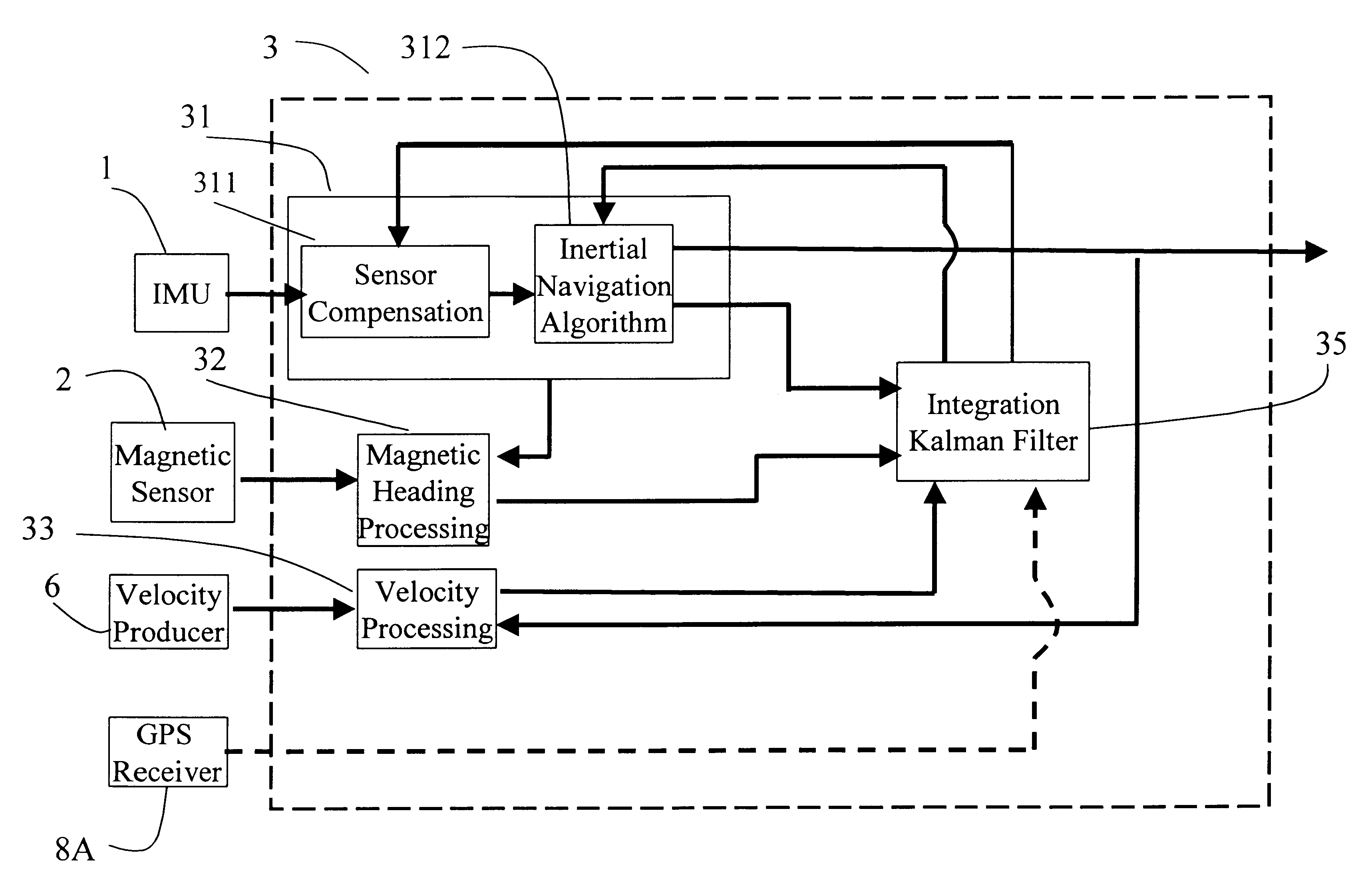
(d) A unique sophisticated Kalman filter. It removes the inherent drift of the free inertial positioning solution derived from the output of the low cost "core micro" IMU by means of fusing information from the "core micro" IMU, magnetic heading sensor, and velocity producer.

Problems solved by technology

Unfortunately, GPS is vulnerable to jamming and shadowing, especially in hand-held applications on land, so that a GPS receiver often can not provide continuous positioning information without interruption, especially in urban area.
However, the cost, size, power, and position-drift characteristics of conventional inertial navigation systems prohibit them from use in commercial hand-held navigation applications.

Method used


Image

  • Interruption-free hand-held positioning method and system thereof
  • Interruption-free hand-held positioning method and system thereof
  • Interruption-free hand-held positioning method and system thereof

Examples


Embodiment Construction

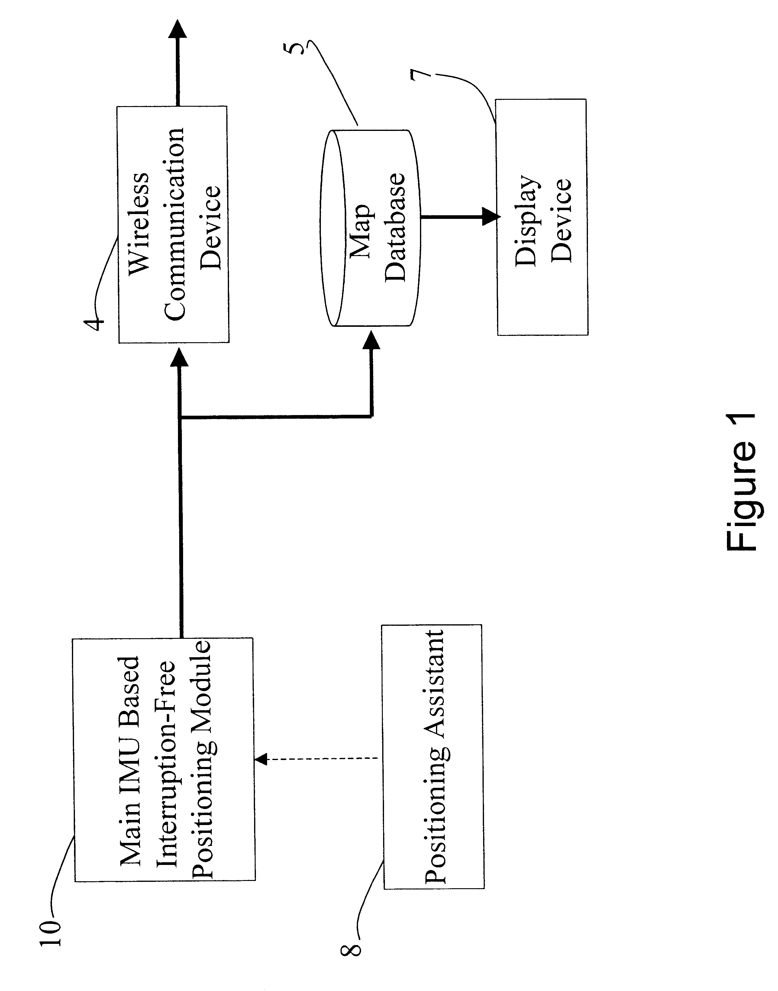
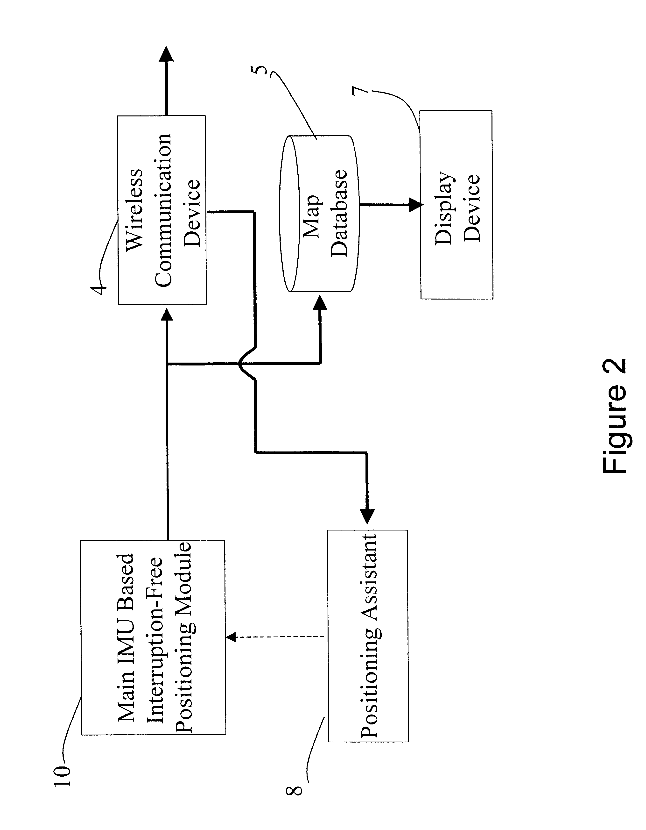
The present invention provides an interruption-free positioning method and a hand-held system thereof for a user on land. Referring to FIG. 1, an interruption-free hand-held positioning system of a user on land comprises a main IMU based interruption-free positioning module 10, a positioning assistant 8, a wireless communication device 4, a map database 5, and a display device.

The main IMU based interruption-free positioning module 10 is utilized for sensing motion measurements of the user by the IMU and producing interruption-free positioning data of the user.

The positioning assistant 8 is adapted for providing interruptible positioning data to assist the main IMU based interruption-free positioning module to achieve an improved interruption-free positioning data of the user.

The wireless communication device 4 is built in for exchanging the improved interruption-free positioning data with other users.

The map database 5 is adapted for providing map data to obtain surrounding map inf...


PUM


Abstract

An interruption-free hand-held positioning method and system, carried by a person, includes an inertial measurement unit, a north finder, a velocity producer, a positioning assistant, a navigation processor, a wireless communication device, and a display device and map database. Output signals of the inertial measurement unit, the velocity producer, the positioning assistant, and the north finder are processed to obtain highly accurate position measurements of the person. The user's position information can be exchanged with other users through the wireless communication device, and the location and surrounding information can be displayed on the display device by accessing a map database with the person position information.

Description

BACKGROUND OF THE PRESENT INVENTION1. Field of the Present InventionThe present invention relates to a positioning method and system for hand-held applications, and more particularly to an interruption-free positioning method and system for hand-held applications, which can ensure the user be provided with accurate positioning data continuously anytime and anywhere, no matter the user is located inside a building, tunnel, forested area, unbanized terrain, or high jamming environment where GPS signals are normally not available.2. Description of Related ArtsCurrent hand-held navigators depend on the GPS (Global Positioning System). The GPS is a satellite radionavigation system, which is owned, deployed, and operated by the U.S. Department of Defense, but is available for commercial uses around the world. Unfortunately, GPS is vulnerable to jamming and shadowing, especially in hand-held applications on land, so that a GPS receiver often can not provide continuous positioning informati...

Claims


Application Information

Patent Timeline
IPC IPC(8): G01C21/20G01S13/00G01S13/60G01S1/00G01S5/00G01S5/14G01S11/02G01S11/00G01S15/02G01S13/86G01S15/00G01S17/00G01S17/02G01S15/86G01S17/86G01S19/44G01S19/49G01S19/55
CPCG01C21/20G01C21/206G01S5/0072G01S13/60G01S19/26G01S19/44G01S19/49G01S11/02G01S13/86G01S15/025G01S17/023G01S19/53G01S17/86G01S15/86G01C21/165
Inventor LIN, CHING-FANGMCCALL, HIRAM
Owner AMERICAN GNC
Learn More