Method and system for geolocating a terminal occupying particular geographical positions

Pending Publication Date: 2021-08-12
SIGFOX
View PDF0 Cites 0 Cited by
  • Summary
  • Abstract
  • Description
  • Claims
  • Application Information

AI Technical Summary

Benefits of technology

The patent describes a method for improving the precision of location estimation in a wireless communication system by eliminating unwanted reference elements and adding relevant ones. This refining process also helps reduce the complexity of the learning algorithm and the size of the radio signature. The method can be easily automated using existing terminals and does not require additional hardware or cost. The ultra-narrowband wireless communication system, which is adapted for the Internet of Things, allows for low-bit rate communications and long range with low energy consumption.

Problems solved by technology

Satellite geolocation is particularly precise, but it suffers from a plurality of disadvantages, in particular the cost and the electricity consumption induced by the integration of a GPS receiver into an object, as well as its lack of performance in closed zones.
This method has, however, mediocre geolocation precision since the coverage zone of a base station can reach several kilometers, or even several tens of kilometers in radius.
These various methods all have, however, the disadvantage of requiring specific equipment and software.
Moreover, they often require a costly synchronization of the various base stations acting as observation points.
The disadvantage of such a method for geolocation via trilateration based on the RSSI levels is its lack of precision due to the fact that the numerous parameters that influence the attenuation of the signal (obstacles, radio interference, movement of the terminal, etc.) make the function that defines the distance on the basis of an RSSI level very complex.
Such methods have, however, several disadvantages, in particular in the case in which the geographic zone to be covered is very vast, for example if an entire country, or even a continent, must be covered.
A first disadvantage relates to the geolocation precision.
The establishment of a relationship between a radio signature and an associated geographic position is thus made difficult because of the noise generated by such situations.
Another disadvantage relates to the complexity of the machine learning algorithm used.
All this contributes to considerably increasing the data at the input of the machine learning algorithm, and thus to creating constraints of capacity and calculation time.
The greater the number of points, the better the performance of the geolocation method in terms of precision, but the longer and the more costly the calibration phase.

Method used


Image

  • Method and system for geolocating a terminal occupying particular geographical positions
  • Method and system for geolocating a terminal occupying particular geographical positions
  • Method and system for geolocating a terminal occupying particular geographical positions

Examples


Embodiment Construction

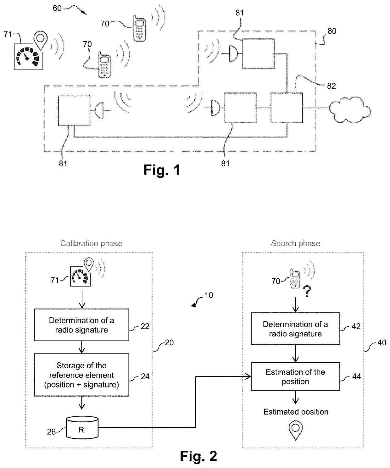
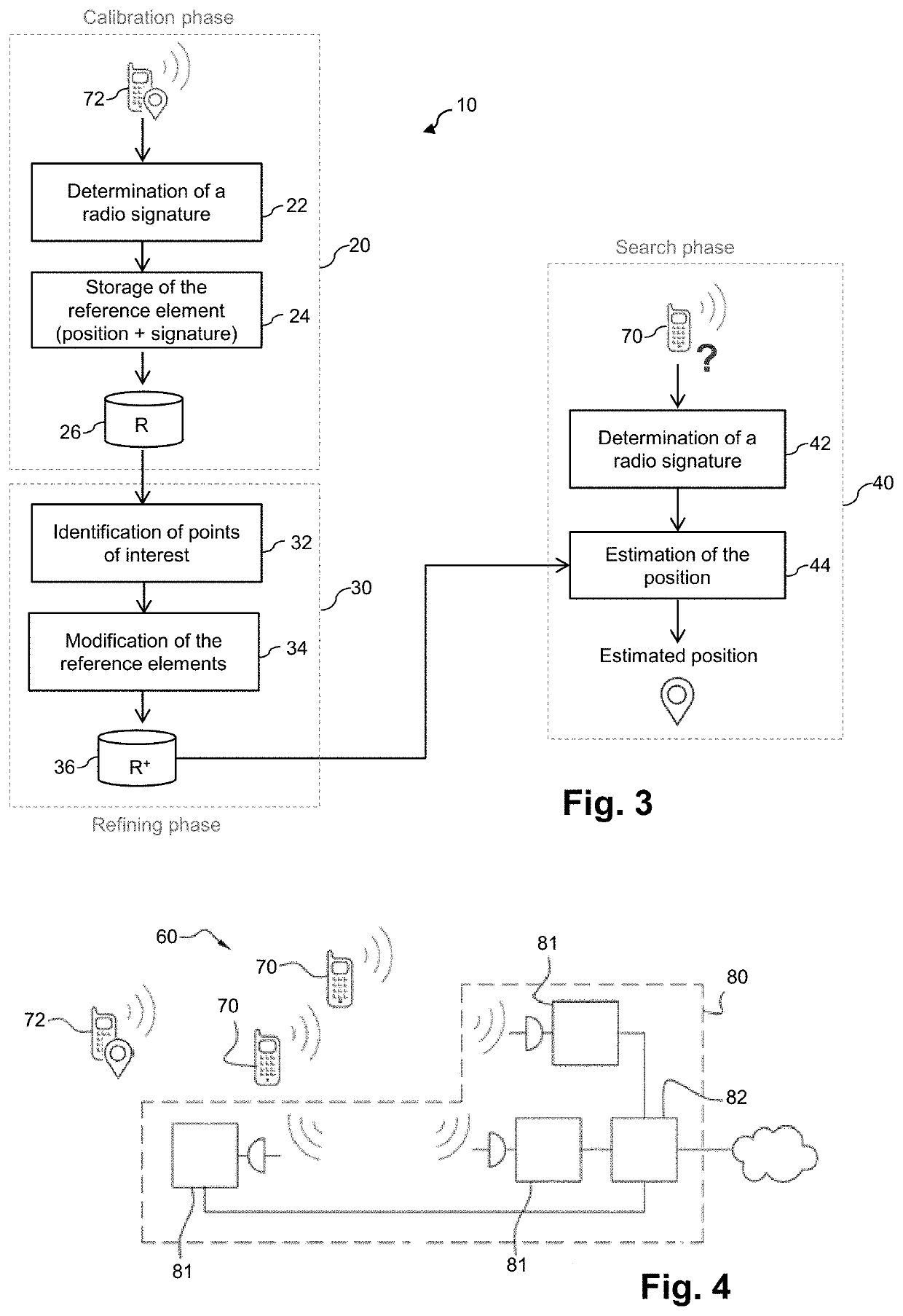
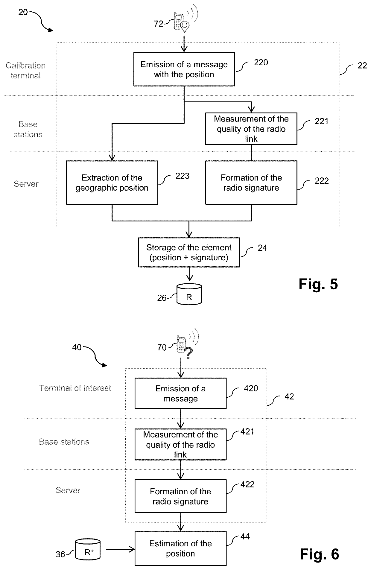
[0085]As indicated above, the present invention aims to estimate the geographic position of a terminal, called “terminal of interest”, of a wireless communication system using a learning method based on information representative of the quality of radio links existing between said terminal and base stations of said wireless communication system.

[0086]FIG. 1 schematically shows a wireless communication system 60, including a plurality of terminals 70 and an access network 80 including a plurality of connected base stations 81 and a server 82 connected to said base stations 81. In such a system 60, the communications can generally be bidirectional, that is to say that data can be transmitted from the access network 80 to a terminal 70 over a downstream radio link, or from a terminal 70 to the access network 80 over an upstream radio link. Thus, a measurement of the quality of the radio link existing between a terminal 70 and a base station 81 of the access network 80 can for example b...


PUM


Abstract

A method for geolocating a terminal of a wireless communication system. A set of reference elements is determined with the aid of messages transmitted by calibration terminals during a calibration phase. Each reference element includes a radio signature and a geographical position of a calibration terminal when a message is transmitted. A refinement phase makes it possible to clean and / or to enrich the set of reference elements by virtue of the identification of points of interest corresponding to preferential positions of transmission of messages by the terminals. During a search phase, the position of a terminal of interest is determined based on its radio signature and of the modified set of reference elements.

Description

TECHNICAL FIELD[0001]The present invention belongs to the field of geolocation. In particular, the invention relates to a method and a system for geolocating a terminal of a wireless communication system. The invention applies particularly well to the geolocation of smart objects of the “Internet of Things” (or IoT) type.BACKGROUND OF THE INVENTION[0002]Over the last few years, the growing use of wireless communication systems has naturally led to developing services based on the geographic position of an object and used for example for navigation assistance, traffic management, monitoring of the transport of merchandise, remote reading of information in general, etc.[0003]Satellite positioning systems like the GPS (“Global Positioning System”) are some of the most well-known geolocation techniques. These systems are based on the use by a receiver terminal of radio signals emitted by dedicated satellites. Satellite geolocation is particularly precise, but it suffers from a plurality...

Claims


Application Information

Patent Timeline
IPC IPC(8): G01S5/10G01S5/02G06N20/00H04W4/029
CPCG01S5/10H04W4/029G06N20/00G01S5/021G01S5/02527G01S5/02524G01S5/02521
Inventor ISSON, OLIVIERMARTY, RENAUD
Owner SIGFOX
Why Eureka
Try Eureka