
Spatial expansion seismic data processing method and apparatus

Active Publication Date: 2014-05-08
CGG SERVICES SA
View PDF2 Cites 10 Cited by
  • Summary
  • Abstract
  • Description
  • Claims
  • Application Information

AI Technical Summary

Benefits of technology

The patent text describes a method for improving the processing of data collected during a geophysical survey, specifically a seismic survey. The method involves moving the seismic sources and receivers in a way that creates a high-density grid of source and recording points over a large area. This allows for more efficient use of the limited number of sources and receivers, and reduces the cost of the survey. The technical effect of this method is to provide a more cost-effective and efficient way to generate high-resolution images of the subsurface for oil and gas reservoirs, environmental monitoring, and other applications.

Problems solved by technology

However, most of the time, the NMO correction is not sufficiently precise and distortions remain.
As a result of the increased offsets, RMO curves become increasingly more difficult to describe and the parabolic model has often been found unsatisfactory.
Furthermore, typical prior art models are unable to describe RMO distortions as a function of azimuth.
In addition to issues with RMO correction, many land and ocean bottom datasets suffer from high levels of noise, which makes the task of processing and interpretation difficult.
Modern single sensor high fold datasets can also exhibit high noise levels due to poor coupling and ground or mud roll.
While this method ensures one trace per bin, the flex bin traces will often not be a good representation of what would have been recorded in those bins, particularly for data with significant dip.
In addition, jitter can be apparent in the data due to irregular sampling within the bins.
As such, the primary energy will be smeared and detail will be lost.
As a consequence, datasets that do not fulfill these requirements, including most 3D land surveys, will suffer from poor processing results (Poole and Lecerf, “Effect of regularisation in the migration of time-lapse data”, First Break, 24, 25-31, 2006).
While working in 5D enables the best possible chance of deriving an accurate Fourier representation of the data, a number of issues remain.
While this assumption is also valid in the offset-x and offset-y directions, sampling in these directions is often so coarse that aliasing can become a problem.
However, by working with 360 degrees, the data is no longer linear, and linear sparseness constraints are no longer suitable.
In a more complex geology, e.g., where there is anisotropy, this is less effective.

Method used


Image

  • Spatial expansion seismic data processing method and apparatus
  • Spatial expansion seismic data processing method and apparatus
  • Spatial expansion seismic data processing method and apparatus

Examples


Embodiment Construction

[0042]The following description of the exemplary embodiments refers to the accompanying drawings. The same reference numbers in different drawings identify the same or similar elements. The following detailed description does not limit the invention. Instead, the scope of the invention is defined by the appended claims.

[0043]Reference throughout the specification to “one embodiment” or “an embodiment” means that a particular feature, structure or characteristic described in connection with an embodiment is included in at least one embodiment of the subject matter disclosed. Thus, the appearance of the phrases “in one embodiment” or “in an embodiment” in various places throughout the specification is not necessarily referring to the same embodiment. Further, the particular features, structures or characteristics may be combined in any suitable manner in one or more embodiments.

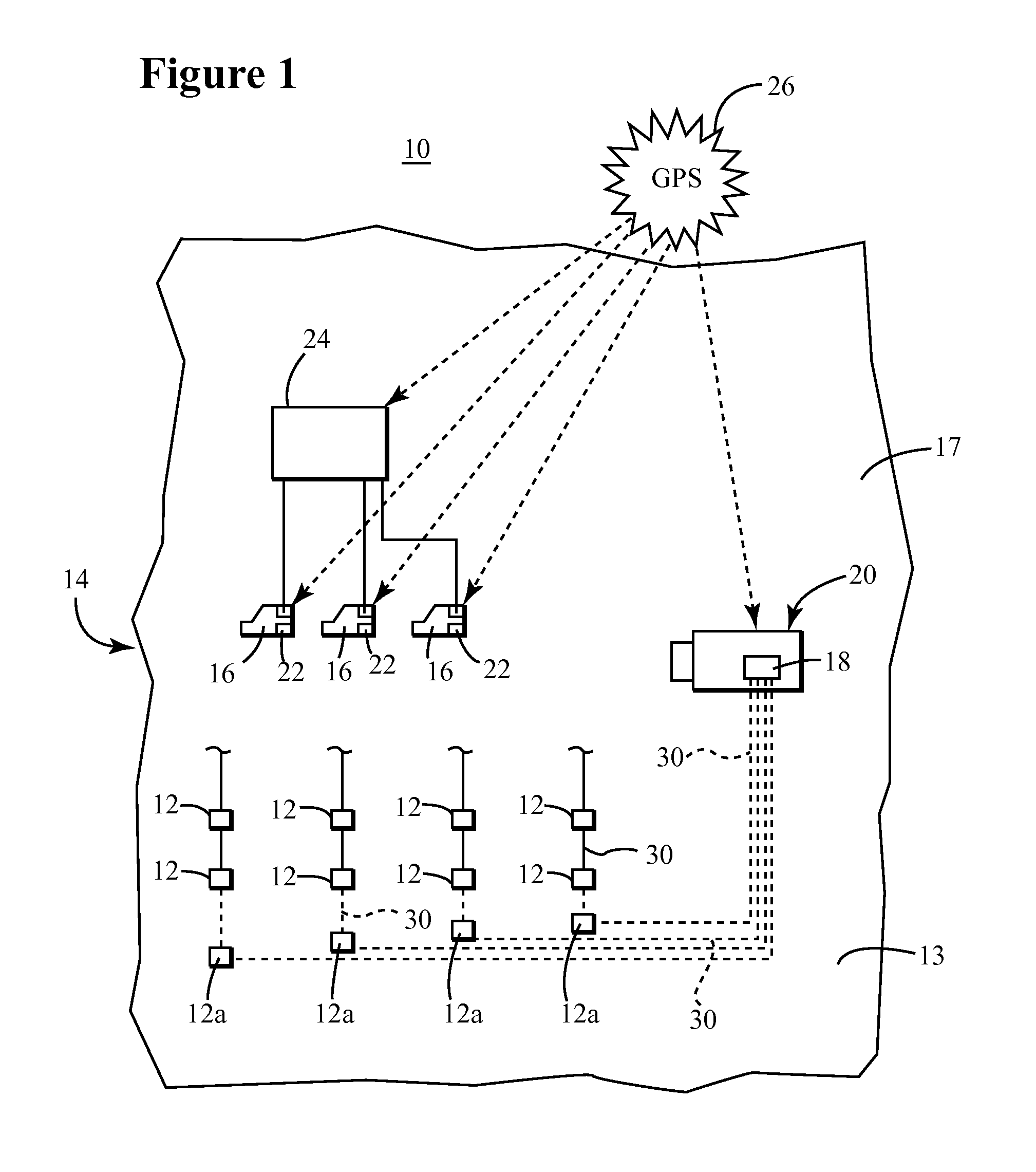
[0044]According to an embodiment, a novel method to process seismic data includes receiving input seismic da...


PUM


Abstract

A method for processing seismic data may include receiving input seismic data (di) comprising N spatial coordinates, where the input seismic data is in a first spatial domain, expanding the N spatial coordinates of the input seismic data (di) to N′ modified spatial coordinates, where N′ is greater than N, to provide spatially expanded seismic data (de) that is in a second spatial domain, transforming the spatially expanded seismic data (de) to a model domain to provide model domain data (dm), and generating a final image (df) of a subsurface using the model domain data (dm).

Description

CROSS-REFERENCE TO RELATED APPLICATIONS[0001]The present application is related to, and claims the benefit of priority of, U.S. Provisional Application 61 / 722,897, entitled “IMPROVED INTERPOLATION OF 5D DATA BY RE-DEFINING MODEL SPACE WITH MORE THAN 5 DIMENSIONS,” authored by Gordon Poole, the entire content of which is incorporated herein by reference.BACKGROUND[0002]1. Technical Field[0003]Embodiments of the subject matter disclosed herein generally relate to the field of geophysical data acquisition and processing. In particular, the embodiments disclosed herein relate to processing data collected during a geophysical survey such as a seismic survey.[0004]2. Discussion of the Background[0005]Geophysical data is useful for a variety of applications such as weather and climate forecasting, environmental monitoring, agriculture, mining, and seismology. As the economic benefits of such data have been proven, and additional applications for geophysical data have been discovered and de...

Claims


Application Information

Patent Timeline
IPC IPC(8): G06K9/00
CPCG06K9/0063G01V1/301G01V1/306G16Z99/00G06F17/10
Inventor POOLE, GORDON
Owner CGG SERVICES SA
Learn More