
Method for making an electronic map for use in a GPS radio communication device by utilizing a paper map under a condition of no GPS electronic map provided

Active Publication Date: 2013-11-21
UNICATION
View PDF1 Cites 7 Cited by
  • Summary
  • Abstract
  • Description
  • Claims
  • Application Information

AI Technical Summary

Benefits of technology

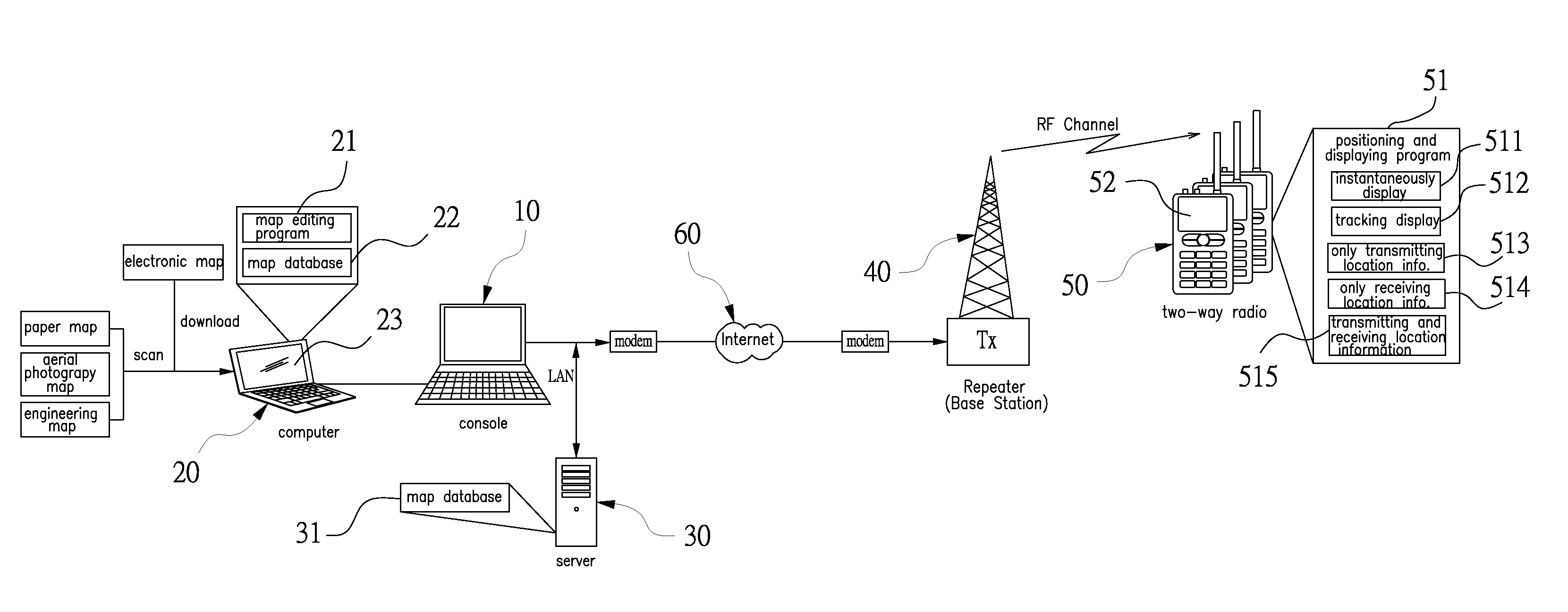
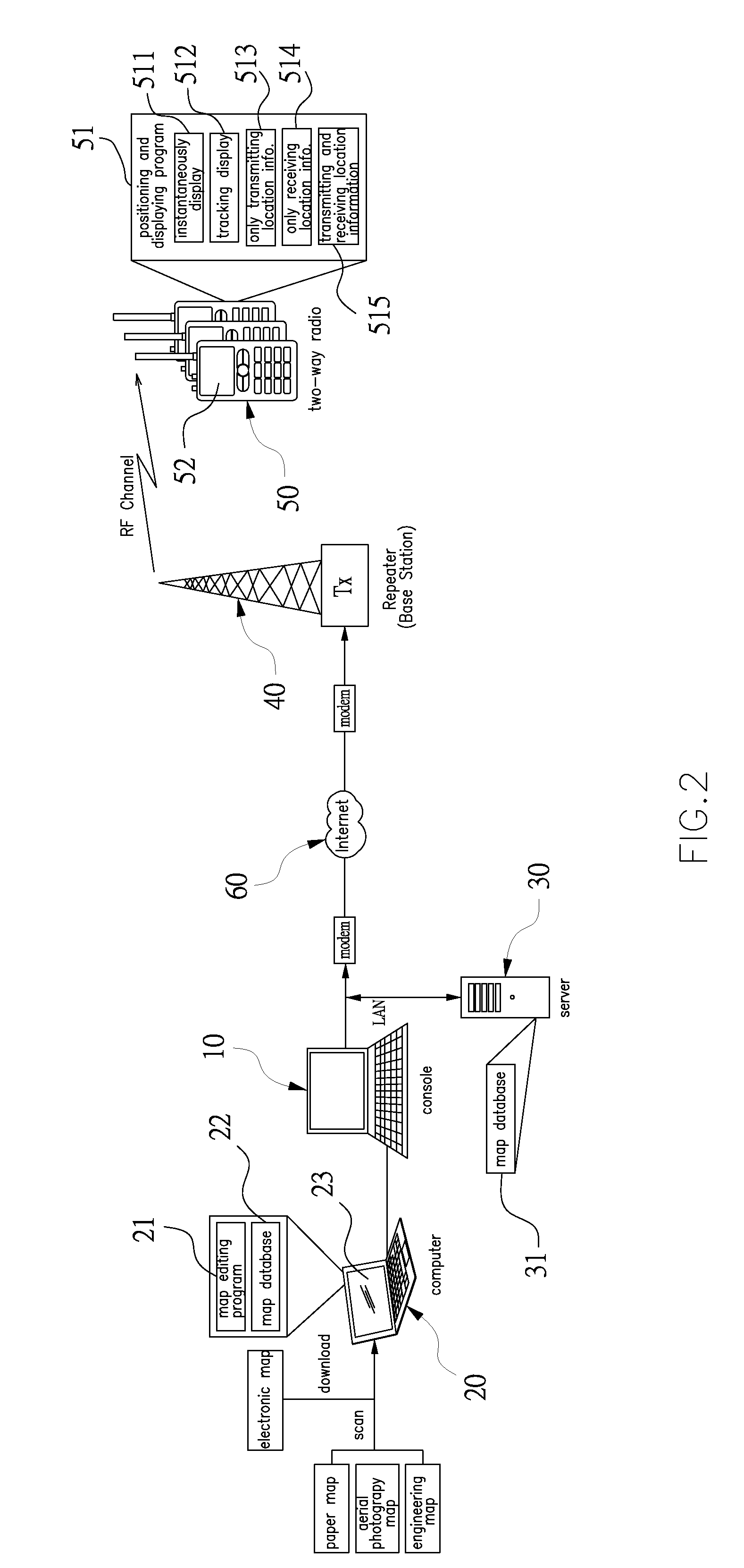
The present invention provides a group two-way radio system that can use a computer to convert any paper map or electronic map that is not in compliance with GPS standards to a GPS-compliant electronic map drawing file. This file is then transmitted to the radios of the users in the group through an existing RF channel. The radios have a positioning and displaying program that combines the map drawing file with GPS location information of each user and displays it on an LCD screen. The system can also retrieve and display map drawing files from a map database on the radios. This allows the users to display a map of their current location and any known reference points on the map. The system can also actively or passively retrieve map drawing files from the map database and display them on the radios' LCD screen. This invention provides a way to make use of existing maps and GPS information in a situation where GPS signals are not available.

Problems solved by technology

For the above-mentioned circumstances, users have to purchase or rent a map software and a application program from certain suppliers for which spending is just one thing to be concerned, and what is more, is the maps provided by the certain suppliers may not be suitable for a specialized group (such firefighters, emergency rescue team, policemen, or the military).
For instance, a precise map of a coast, forest, high mountain and wild fields, or an interior plan of an airport, a market, school, office building and a military organization, is what traditional map suppliers cannot provide for users.
As a result, when a rescue team is carrying out an emergent operation in a condition of failing to obtain a GPS standard map from the market for an emergency event site, communication devices used by the rescue team are not capable of launching the GPS system for figuring out topography and circulation of the event site, whereby causing problems of dispatch, command, or rescue from the group or even worse extensive damage or disaster.

Method used


Image

  • Method for making an electronic map for use in a GPS radio communication device by utilizing a paper map under a condition of no GPS electronic map provided
  • Method for making an electronic map for use in a GPS radio communication device by utilizing a paper map under a condition of no GPS electronic map provided
  • Method for making an electronic map for use in a GPS radio communication device by utilizing a paper map under a condition of no GPS electronic map provided

Examples


Embodiment Construction

[0022]For better and further knowledge and understanding of the device and efficacy of the present invention, embodiments are hereby given with detailed descriptions in cooperation with the attached drawings below.

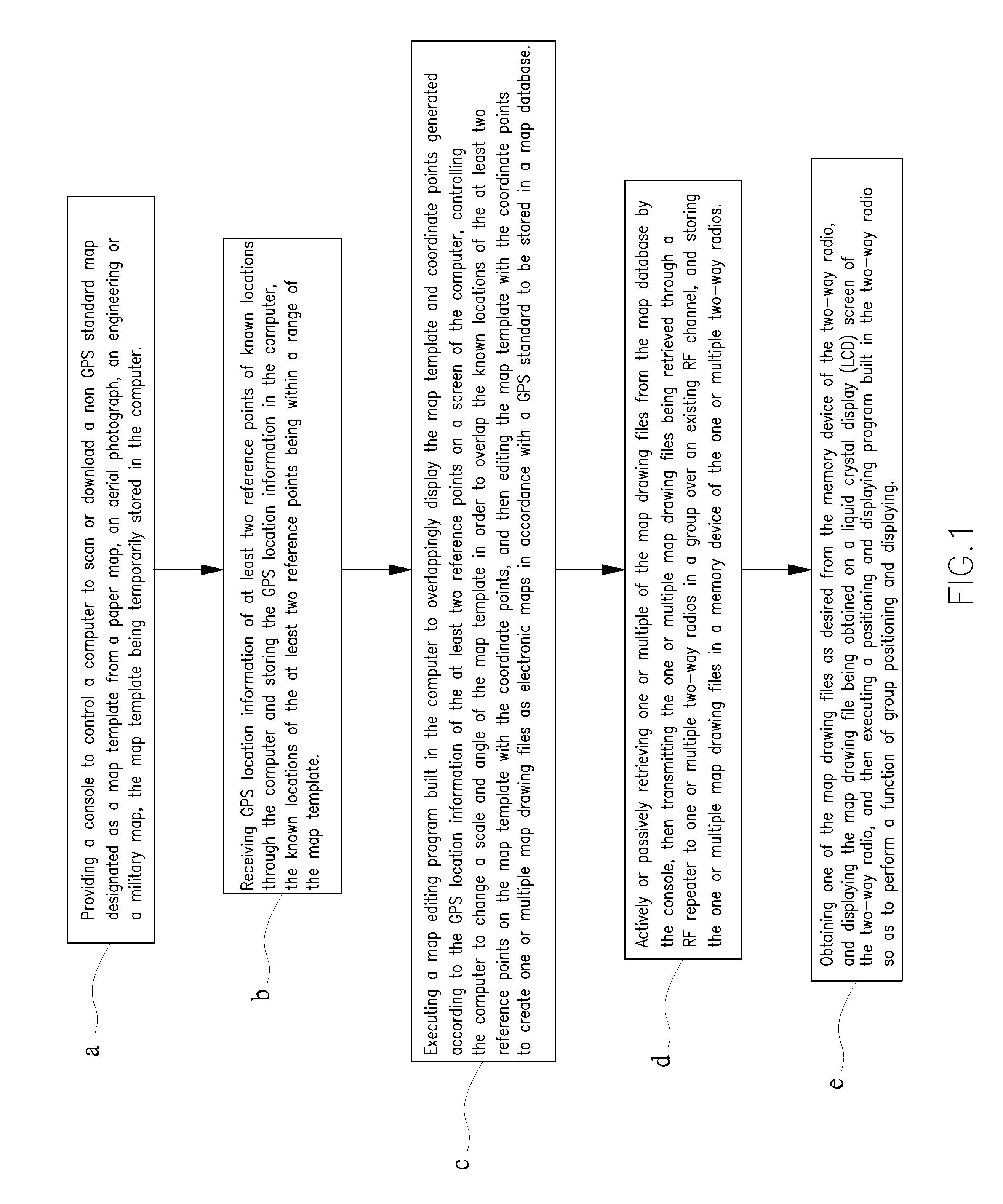
[0023]Referring to FIG. 1, a method for making an electronic map for use in a global positioning system (GPS) radio communication device by utilizing a paper map under a condition of no GPS electronic map provided, comprises steps of:[0024]a. providing a console to control a computer to scan or download a non GPS standard map designated as a map template from a paper map, an aerial photograph, an engineering or a military map, the map template being temporarily stored in the computer;[0025]b. receiving GPS location information of at least two reference points of known locations through the computer and storing the GPS location information in the computer, the known locations of the at least two reference points being within a range of the map template;[0026]c. executing a ...


PUM


Abstract

A group two-way radio system, in a condition of failing to obtain a GPS standard map, is capable of utilizing a console to control a computer to convert any paper map or electronic map not in compliance with a GPS standard to be an electronic map drawing file in compliance with the GPS standard. The map drawing file is transmitted through a RF repeater over an existing RF channel to one or multiple two-way radios in the group so as to enable the two-way radio to perform a method of group positioning and displaying based on the map drawing file.

Description

CROSS-REFERENCE TO RELATED APPLICATION[0001]This application is a continuation-in-part of U.S. patent application Ser. No. 13 / 448,593, filed Apr. 17, 2012, priority of the filing date of which is hereby claimed under 35 U.S.C. §120.BACKGROUND OF THE INVENTION[0002]1. Field of the Invention[0003]The present invention relates to a method and system of making an electronic map for use in a global positioning system (GPS) radio communication device by utilizing a paper map under a condition of no GPS electronic map provided, and particularly to a group two-way radio system that, in a condition of failing to obtain a GPS map from a market, is capable of utilizing a computer by a console to convert and edit any non-GPS standard map to be an electronic map drawing file in compliance with a GPS standard where the electronic map drawing being made is then transmitted through a radio frequency (RF) repeater over an existing RF channel to two-way radios in the group for performing a function o...

Claims


Application Information

Patent Timeline
IPC IPC(8): G01C21/00
CPCG01C21/00G01C21/20G09B29/106G01C21/3844G01C21/3896G01C21/3841
Inventor YEH, SHIH-TSENG
Owner UNICATION
Learn More