
Client Agnostic Spatial Workflow Form Definition and Rendering

a client-agnostic, workflow technology, applied in the field of client-agnostic spatial workflow form definition and rendering, can solve the problem of restricting the ability to perform these operations to centralized server systems, and achieve the effect of accelerating productivity and flexibility

Inactive Publication Date: 2013-10-24
LATITUDE GEOGRAPHICS GRP
View PDF4 Cites 27 Cited by
  • Summary
  • Abstract
  • Description
  • Claims
  • Application Information

AI Technical Summary

Benefits of technology

The invention provides a method and apparatus for creating, using, and viewing spatial workflow forms. The system uses a GUI tool to allow users to layout such forms for client application rendering, display, and data collection. The spatial workflow form is represented as XML and can be accessed by various client applications. The user can complete the form with their own geometry and attribute collection mechanisms, and the data collected is then returned to the server for further processing. The technical effect is the creation of a flexible and efficient tool for spatial workflows.

Problems solved by technology

This is due to the fact that these spatial datasets are large (multi-terabyte) and require significant processing and memory resources in order to perform analysis and querying.
Limitations of network speed, local storage and processing capability restrict the ability to perform these operations to centralized server systems.

Method used


Image

  • Client Agnostic Spatial Workflow Form Definition and Rendering
  • Client Agnostic Spatial Workflow Form Definition and Rendering
  • Client Agnostic Spatial Workflow Form Definition and Rendering

Examples


Embodiment Construction

[0044]Exemplary embodiments of the invention bring together a number of software and business components in order to realize the best mode for implementation.

[0045]Actors that interact with an exemplary embodiment of the invention fall into several categories. These are the workflow designer, the workflow developer and the workflow user.

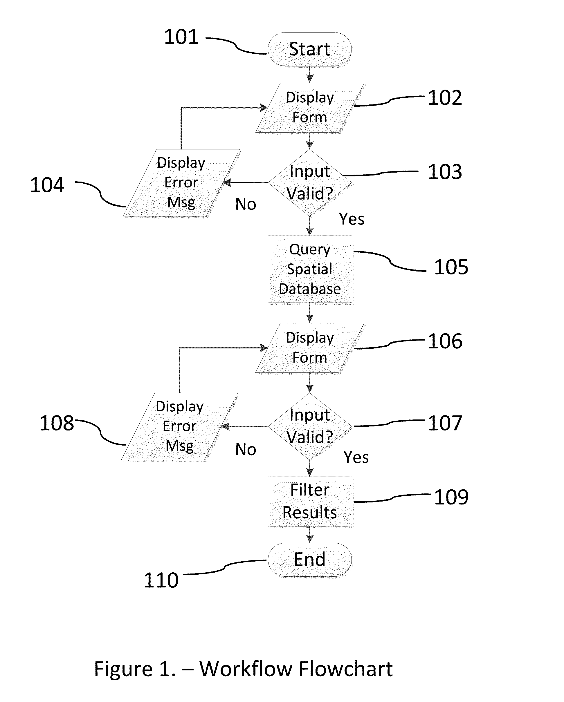
[0046]Prior to implementing any software embodiment of the invention, it is the workflow designer's responsibility to design the workflow to closely mimic a real-world, spatial workflow. The designer accomplishes this task by interviewing, researching, observing and documenting one or more spatial workflows. The workflow designer may then elect to document the workflow using a flowchart, as shown in FIG. 1. The purpose of the flowchart is to articulate the spatial workflow in conceptual form to aid implementation, as well as being a mechanism for workflows users to review and validate the workflow designer's assumptions. The workflow described in FIG...


PUM


Abstract

A method for building client agnostic, discoverable service oriented workflow forms for collecting spatial data input composed of spatial features and metadata is described that permits a workflow engine to export a user-defined spatial workflow represented as a service and described as XML. This workflow is composed of numerous spatial and non-spatial workflow activities chained together and includes forms for collecting user input. These forms are described using XML and can be rendered on clients irrespective of their user interface technology.

Description

TECHNICAL FIELD OF THE INVENTION[0001]This method relates to the design and use of user interface forms in a larger spatial workflow for collecting spatial data in the form of spatial features (points, lines, polygons) and associated attributes (metadata) in a client-server environment of mixed platforms.BACKGROUND OF THE INVENTION[0002]In Client-Server systems, typified by proprietary or open standards based communication, there is communication that occurs between endpoints to transfer data, update state, capture input, perform processing and other functions of each respective endpoint.[0003]This series of steps that involve processing on the client or server and the intercommunication of said processing can be described as a workflow. In most situations, the client or “user” of the system initiates a workflow, but is also possible for a server system to act as a client as well.[0004]Workflows are designed to mimic or capture a process that exists in the real world. Spatial workfl...

Claims


Application Information

Patent Timeline
Patent Type & Authority Applications(United States)
IPC IPC(8): G06F17/00G06F15/16
CPCG06Q10/10G06F16/29G06F40/154
Inventor STEVENSON, DAVIDMORIN, CHRISTIANCOONEY, RYAN
Owner LATITUDE GEOGRAPHICS GRP
Learn More