Method of Resolving a Location From Data Representative Thereof

Inactive Publication Date: 2013-01-31
TELE ATLAS NORTH AMERICA
View PDF12 Cites 43 Cited by
  • Summary
  • Abstract
  • Description
  • Claims
  • Application Information

AI Technical Summary

Benefits of technology

The present invention provides a method for accurately matching nodes, lines, or segments in a first digital map to a second digital map using relevance information such as curvature or elevation. This technique improves accuracy and computational benefits when resolving the location of a node or line in another map, even if the maps have different levels of completeness and positional accuracy. By using elevation or curvature information, the method allows for the identification of lines or segments that emanate from or are incident at a reference point in the first map, even when there are multiple possibilities for a line or segment in the second map. In cases where there is no clear evidence of which line or segment is the best fit to a reference point, the method takes into account the curvature or elevation information to determine the best match. Overall, this invention provides an efficient and effective approach to identifying relevant nodes, lines, or segments in a digital map.

Problems solved by technology

In the context of devising a means of efficiently referencing or describing a location (i.e. a path through a road network), it is not only highly inefficient simply to provide an ordered list of all nodes (and / or segments, and optionally their attributes) within the digital map which form part of the location, but such a referencing method would necessitate that exactly the same digital map was used during any de-referencing which later occurred, for example in a mobile device to which the location reference was transmitted, because nodes, segments, lines and their attributes are practically only ever uniquely defined in a particular version of a map created by a particular map vendor.
However, as it is becoming possible to identify traffic build up on secondary and urban roads using GSM and GPS probe data (e.g. vehicles users increasingly possess either a mobile phone or a connected satellite navigation devices useful as probes), TMC location codes are simply inadequate as far resolution is concerned.
Although this referencing approach is comprehensive in that it is possible to accurately and repeatably encode and decode any location existing within a geographical information system, it is believed that that the system is excessive and possibly redundant in certain aspects, and a more efficient encoding and decoding system is possible.

Method used


Image

  • Method of Resolving a Location From Data Representative Thereof
  • Method of Resolving a Location From Data Representative Thereof
  • Method of Resolving a Location From Data Representative Thereof

Examples


Embodiment Construction

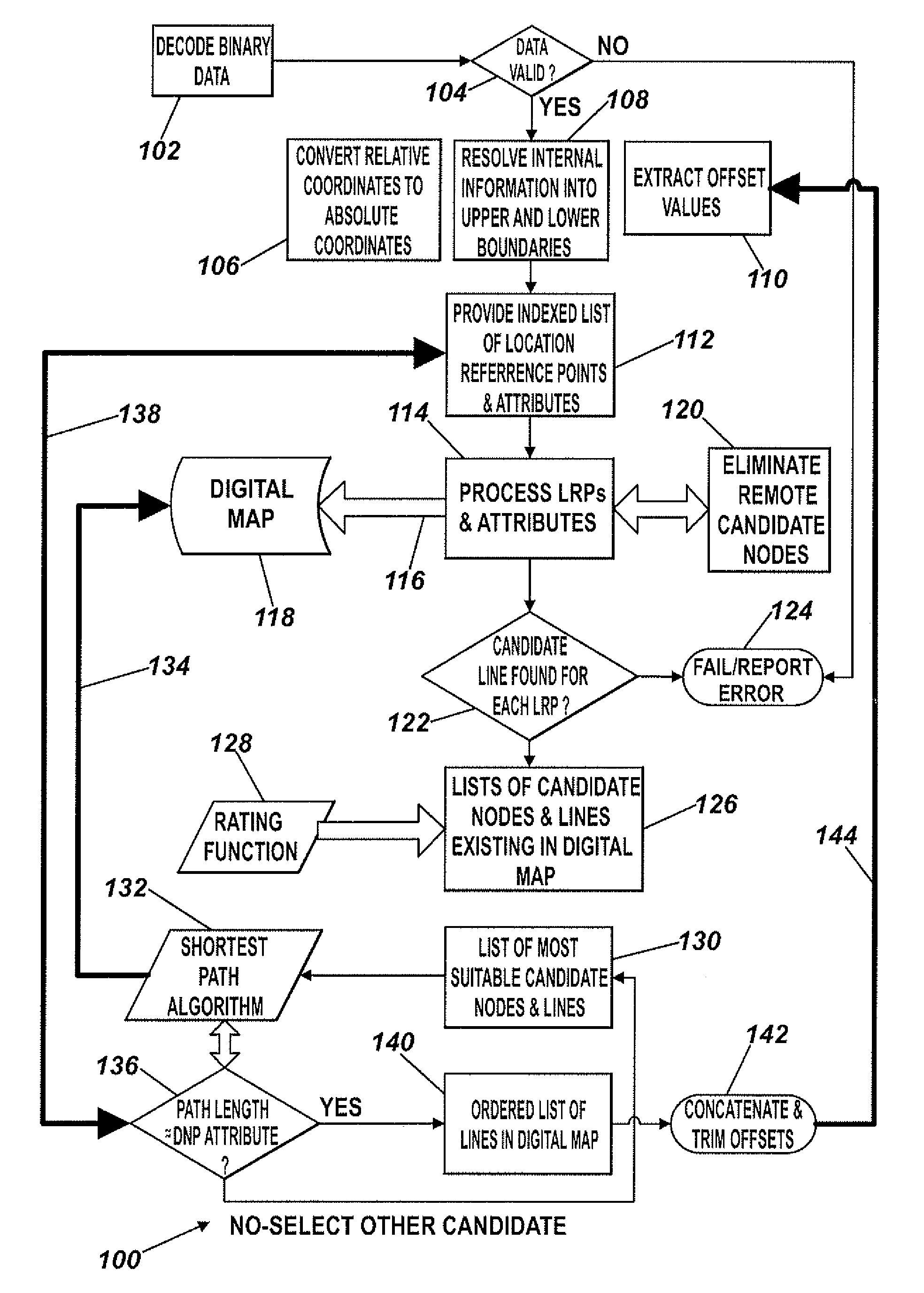
[0139]The following description of the invention is provided in terms of segments, but it is to be understood that the method can be applied equally to lines, or to combinations of lines and segments which together are representative of a continuous path through a road network.

[0140]It is useful in the context of the present invention to firstly provide a brief description of the manner in which a location reference is encoded, and the particular logical and physical data formats used in the encoding process. The latter are provided as an Appendix to this specification, and reference to this Appendix is to be had throughout the following description.

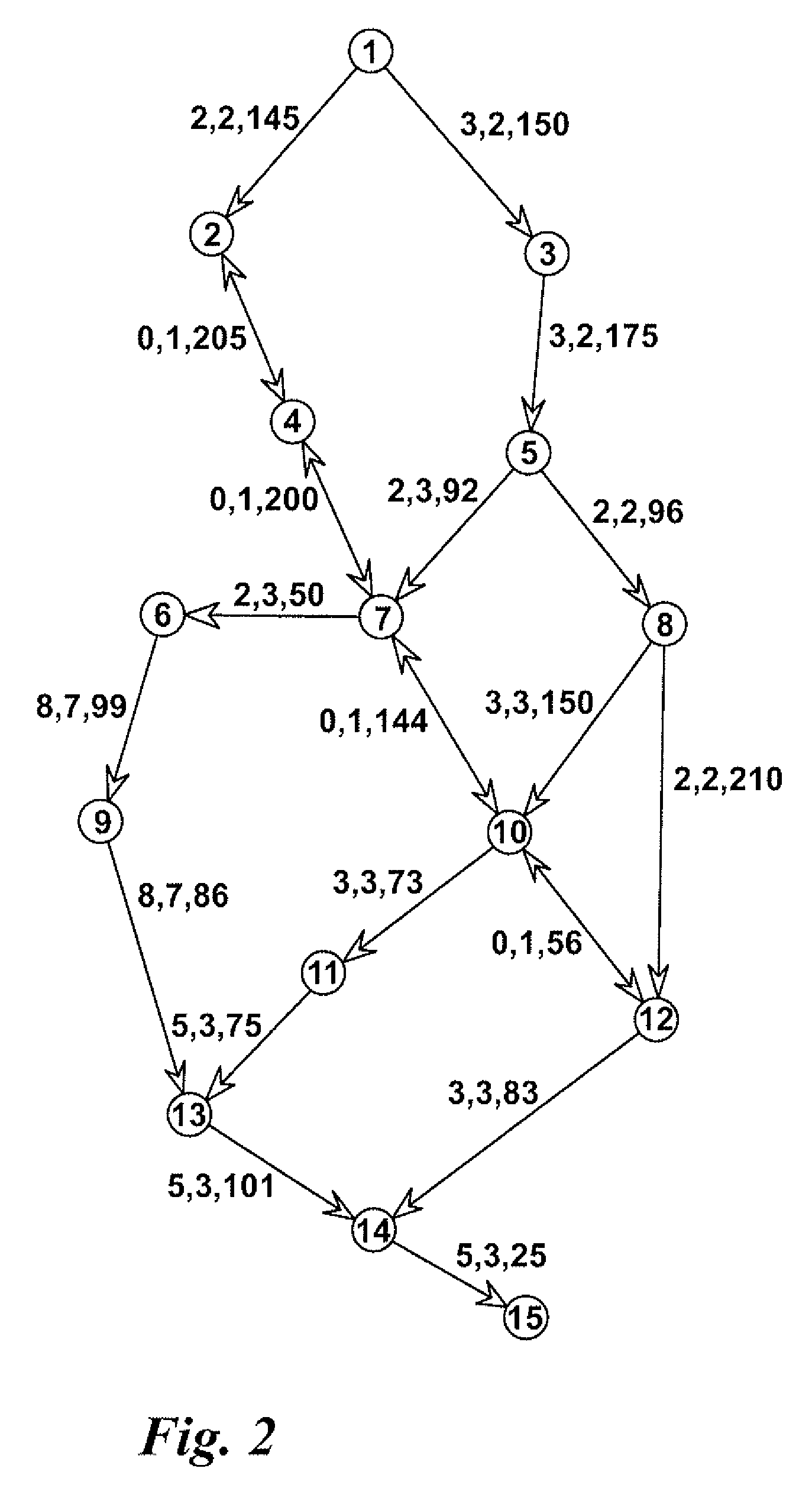
[0141]Referring firstly to FIGS. 2-5, a first (encoder) digital map is shown in FIG. 2 and consists of 15 nodes and 23 lines (two-way lines are counted twice). The nodes are numbered from 1 to 15. The necessary line attributes are shown beside every line using the format: , , . FRC is an abbreviation for “Functional Road Class” and FOW i...


PUM


Abstract

The invention provides a method of resolving a location in a second digital map from an ordered list of location reference points determined from a first digital map. The method involves identifying candidate lines and nodes in the second digital map, and using curvature, height and gradient information associated with the location reference points to identify the most likely candidate nodes or lines in the second digital map corresponding to the nodes represented by the location reference points and to lines emanating from or incident at the node in the first digital map. The method involves carrying out a route search between the most likely identified candidate node or line identified for one location reference point, and the corresponding node or line associated with the next reference point in the list, and repeating this step for consecutive pairs of reference points until the final location reference point is reached.

Description

FIELD OF THE INVENTION[0001]The present invention is concerned with an improved method of resolving a location represented by data encoded according to one or more predetermined formats, and more specifically is concerned with an improved method for accurately determining a location within a digital map, such as those created and sold by Tele Atlas B.V. and Navteq Inc., in a manner which is not dependent on the particular digital map used during a decoding process and yet is identical to the originally encoded location.[0002]Although the term “location” in the context of digital mapping can mean any of a variety of different physical, real-world features (e.g. a point location on the surface of the earth, a continuous path or route, or a contiguous chain of such, of navigable thoroughfares existing on earth, or an area or region on earth capable, in the case of a rectangular, square or circular area, of being defined by two or more parameters), this invention is most applicable to a...

Claims


Application Information

Patent Timeline
IPC IPC(8): G01C21/34
CPCG01C21/32G01C21/30G09B29/106G06F17/30241G06F16/29G01C21/3874G01C21/3811G01C21/3841G01C21/3856
Inventor HAGAN, JAMES EDWARD
Owner TELE ATLAS NORTH AMERICA
Why Eureka
Try Eureka