
System and method of passive and autonomous navigation of space vehicles using an extended kalman filter

a technology of passive and autonomous navigation and space vehicles, applied in the field of space situational awareness, can solve the problems of increasing system mass and cost, increasing system complexity, and requiring additional capability

Active Publication Date: 2010-02-11
RAYTHEON CO
View PDF3 Cites 26 Cited by
  • Summary
  • Abstract
  • Description
  • Claims
  • Application Information

AI Technical Summary

Benefits of technology

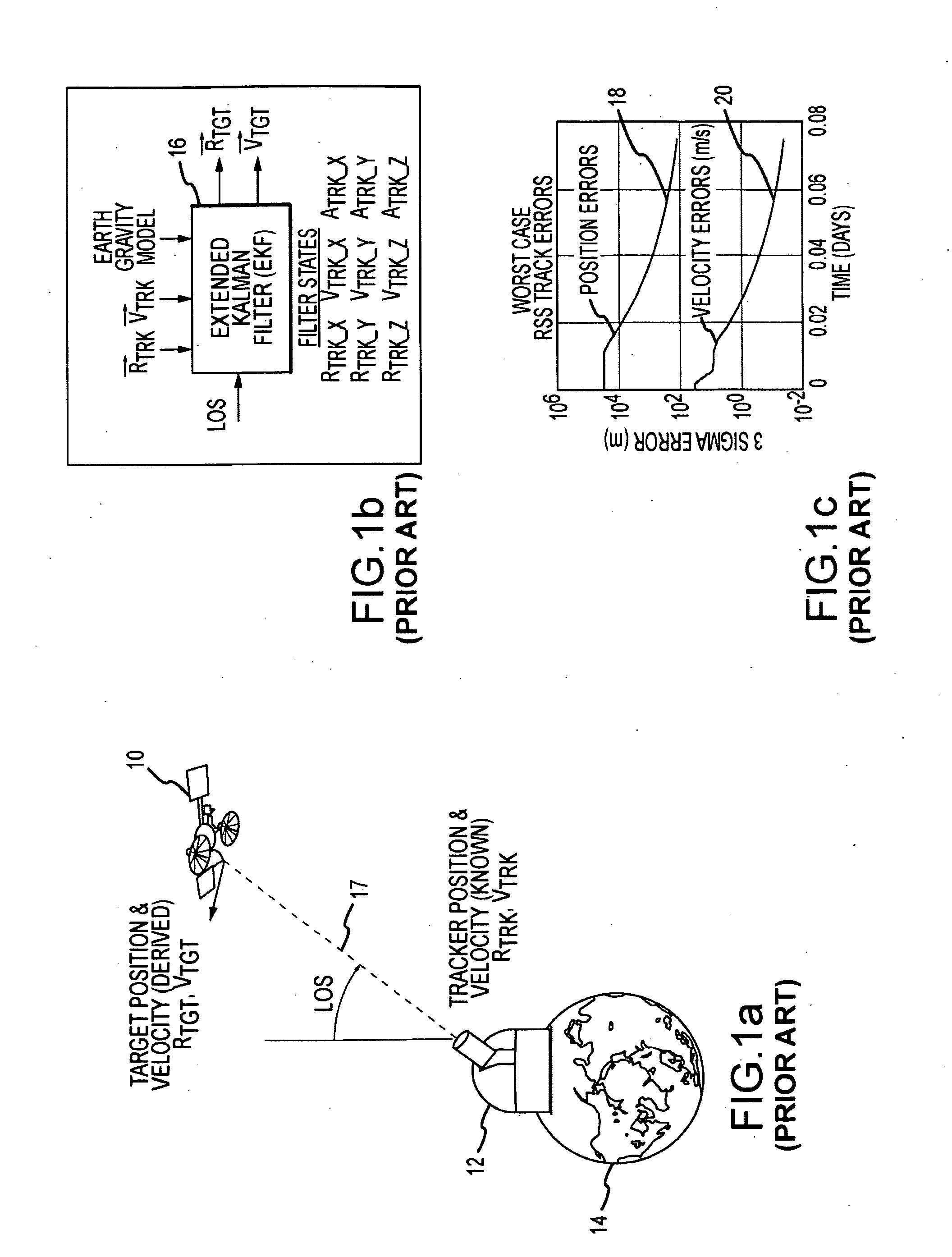
[0026]This is accomplished by reconfiguring the extended Kalman filter, or more generally any predictor / correction class filter, to include states for both the target and tracker vehicles. For the EKF, the measurement matrix H and state transition matrix F are reconfigured to include 18 states, 9 each for the tracker and the target. The target and tracker vehicles must both follow trajectories in an inertial frame of reference through the field of a body having a known gravitational model. Both vehicles must be objects that are under the influence of the gravitational body. The reconfigured filter simultaneously estimates the position and velocity of both tracking and target space-based vehicles from line-of-sight measurements. Known maneuvers such as a known acceleration of either vehicle, typically the tracker vehicle, may be provided to the filter. Depending upon the application, the position and velocity of either the tracker or the target or both vehicles may be output at the same or different times.

Problems solved by technology

Though all these methods work, most of them require the active participation of ground based Earth assets to complete a solution.
GPS is a commonly used autonomous navigation technique, but it becomes increasingly difficult to implement beyond the radius of its 12 hour orbit.
Larger antennas are required to receive signals from the far side of the Earth and / or local satellite backlobes, thus increasing system mass and cost.
This approach does have the drawback of requiring additional capability (e.g. GPS antenna and processing) to estimate the tracker position and velocity, which is then fed into the EKF with the LOS measurements.

Method used


Image

  • System and method of passive and autonomous navigation of space vehicles using an extended kalman filter
  • System and method of passive and autonomous navigation of space vehicles using an extended kalman filter
  • System and method of passive and autonomous navigation of space vehicles using an extended kalman filter

Examples


Embodiment Construction

[0034]It is presumed and commonly accepted by those skilled in the art of satellite navigation and Kalman filter design that the filter must be provided with updated and accurate tracker position and velocity a priori in order to determine target position and velocity. Indeed, it is generally asserted that without a priori knowledge (known or measured values) of the tracker position and velocity, line of sight measurements between satellites do not contain adequate information to infer target states. The system is underdetermined and thus an infinite number of solutions exist.

[0035]In fact, if the extended Kalman filter is reconfigured there is sufficient observability to estimate both target and tracker states relative to an inertial frame of reference in the gravitational field of a gravitation body. Typically, the inertial frame of reference is coincident with an Earth centered coordinate frame (or that of the gravitational body) to simplify the filter equations and produce posit...


PUM


Abstract

It is presumed and commonly accepted by those skilled in the art of satellite navigation and Kalman filter design that the filter must be provided with the tracker position and velocity a priori in order to determine target position and velocity. Indeed, it is generally asserted that without a priori knowledge (known or measured values) of the tracker position and velocity, line of sight measurements between satellites do not contain adequate information to infer target states. Passive and autonomous navigation of space vehicles without a priori values for the position and velocity of either the target or tracker vehicle is achieved by reconfiguring the extended Kalman filter, or more generally any predictor / correction class filter, to include states for both the target and tracker vehicles. The target and tracker vehicles must both follow trajectories in an inertial frame of reference through the gravitational field of a gravitational body having a known gravitational model. The reconfigured filter simultaneously estimates the position and velocity of both tracking and target space-based vehicles from line-of-sight measurements.

Description

BACKGROUND OF THE INVENTION[0001]1. Field of the Invention[0002]This invention relates to space situational awareness and more particularly to a passive and autonomous system and method for simultaneously determining the position and velocity % of both tracking and target space-based vehicles from line-of-sight measurements.[0003]2. Description of the Related Art[0004]Space vehicle navigation done for satellites and / or probes uses a number of technologies such as optical trackers, radars, GPS etc. Though all these methods work, most of them require the active participation of ground based Earth assets to complete a solution. As the number of satellites in orbit and other space vehicles on non-orbiting trajectories continues to proliferate exponentially, the demands upon these aforementioned ground based assets are increasing in kind. To reduce the demands for expensive infrastructure upgrades, more satellites are commonly executing some form of autonomous navigation.[0005]GPS is a c...

Claims


Application Information

Patent Timeline
Patent Type & Authority Applications(United States)
IPC IPC(8): G01C21/24G01C21/16G06K9/00
CPCB64G1/242G05D1/0883B64G1/361B64G1/36B64G1/244
Inventor VANCE, LEONARD D.
Owner RAYTHEON CO
Learn More