
Locating Linear Reference System Events in a Geographic Information System

a geographic information system and reference system technology, applied in the field of data transformation, can solve the problems of inability to solve problems such as time-consuming and difficult use, confusion of two data sets, and high cost of purchasing software for addressing this task,

Inactive Publication Date: 2009-07-09
TELE ATLAS NORTH AMERICA
View PDF1 Cites 20 Cited by
  • Summary
  • Abstract
  • Description
  • Claims
  • Application Information

AI Technical Summary

Problems solved by technology

Unfortunately, conflation of the two data sets is far from obvious.
Further, complications can arise from the fact that GIS data uses planimetric measurements, whereas LRS data employs direct measurement of the distance between two points.
When new LRS events occur and need to be located in an associated GIS, currently available software for addressing this task is very expensive to purchase and is time-consuming and difficult to use.
However, the process is complex, and there are various optimizations that trade off quality for time.
Often the quality of the new street database and event locations cannot be determined until after the process is run and the results tested.

Method used


Image

  • Locating Linear Reference System Events in a Geographic Information System
  • Locating Linear Reference System Events in a Geographic Information System
  • Locating Linear Reference System Events in a Geographic Information System

Examples


Embodiment Construction

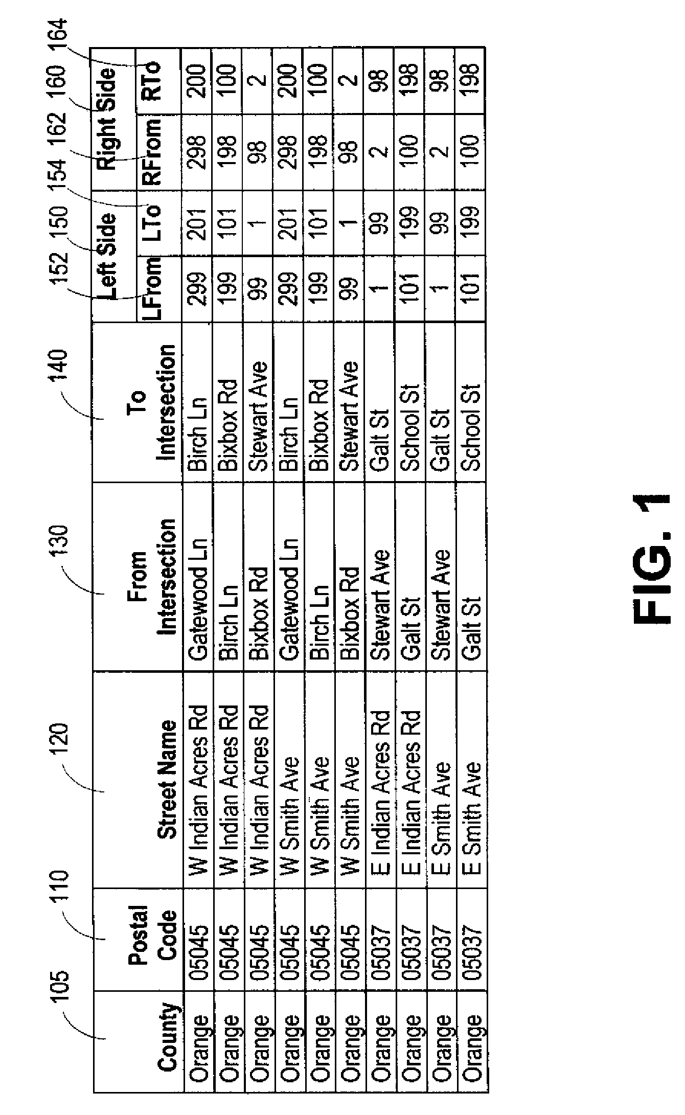
[0036]Generally described, a method and system are provided for determining the geographic locations of events in a Department of Transportation (DOT) Linear Reference System (LRS). That is, a DOT can use this method and system to find where a particular LRS event is located on the face of the earth, for example, to dispatch a maintenance crew. This method and system can be useful for representing LRS events in a geographic database used by a geographic information system (GIS) to display, map, and analyze spatial information.

[0037]LRS data is conflated with GIS data for use in electronic maps and electronic databases. A LRS event geocoding database is created and geocoding software is used to generate the location of an event from the linear measure implicit in an event identifier. The event identifier, description, and location are subsequently inserted into the appropriate layer of a pre-existing and unmodified geographic database for mapping and display. The geocoding database m...


PUM


Abstract

A method and system are provided for determining the geographic locations of events in a linear referencing system (LRS), such as a LRS for the Department of Transportation. The method and system utilize similarities between a LRS and the postal addressing system used in the United States. A LRS event geocoding database and schema are created from portions of the postal addressing system schema and geographic information system (GIS) schema. LRS data is encoded as postal address data as defined in the postal addressing system. The LRS data and GIS data are conflated to populate the LRS event geocoding database using similar transformation logic as for current postal address geocoding. The geographic location of a given LRS event is generated using geocoding software that utilizes the linear measure implicit in the LRS event identifier and the LRS event geocoding database.

Description

CLAIM OF PRIORITY[0001]This application claims priority to U.S. Provisional Patent Application 61 / 019,820 filed Jan. 8, 2008, by James B. Clark and Brad Hibner, entitled “LOCATING LINEAR REFERENCE SYSTEM EVENTS IN A GEOGRAPHIC INFORMATION SYSTEM,” which is hereby incorporated by reference.BACKGROUND OF THE INVENTION[0002]1. Field of the Invention[0003]The invention is related to data transformation and, specifically, to a method and system for determining the correct representation of the geographic location of new events in a Linear Reference System (LRS).[0004]2. Description of the Related Art[0005]In mapping and related applications, the need regularly arises to combine Linear Reference System (LRS) data, in particular events of interest, with data obtained from Geographic Information Systems (GIS). A LRS is a system in which events of interest, such as data related to roads, railways, and rivers are localized by a measure along a linear element. Some examples of events of intere...

Claims


Application Information

Patent Timeline
IPC IPC(8): G01C21/36G06F17/30
CPCG06F17/30241G06F16/29
Inventor CLARK, JAMES B.HIBNER, BRAD
Owner TELE ATLAS NORTH AMERICA
Learn More