Method for processing dynamic display of grid electronic map

An electronic map and dynamic display technology, which is applied in the field of navigation and positioning, can solve the problems of difficult promotion of terminals, limited functions of navigation and positioning, and application restrictions of positioning and navigation.

Inactive Publication Date: 2005-11-30
WUHAN HONGXIN TELECOMM TECH CO LTD
View PDF0 Cites 9 Cited by
  • Summary
  • Abstract
  • Description
  • Claims
  • Application Information

AI Technical Summary

Problems solved by technology

[0008] 1. There are some mobile terminals that are not equipped with electronic maps. These terminals can only simply prompt the current latitude and longitude information, but cannot indicate clear location information. Therefore, in fact, the functions in navigation and positioning are limited, and they can only play The role of a data collection, so its application in positioning and navigation is also subject to greater restrictions
[0009] 2. Mobile terminals equipped with electronic maps have high requirements for terminal configuration, fast processing speed and large storage space, which indirectly increases the cost of mobile terminals. Difficult to promote on a large scale

Method used


Image

  • Method for processing dynamic display of grid electronic map
  • Method for processing dynamic display of grid electronic map

Examples


Embodiment Construction

[0024] Further illustrate the present invention below in conjunction with accompanying drawing.

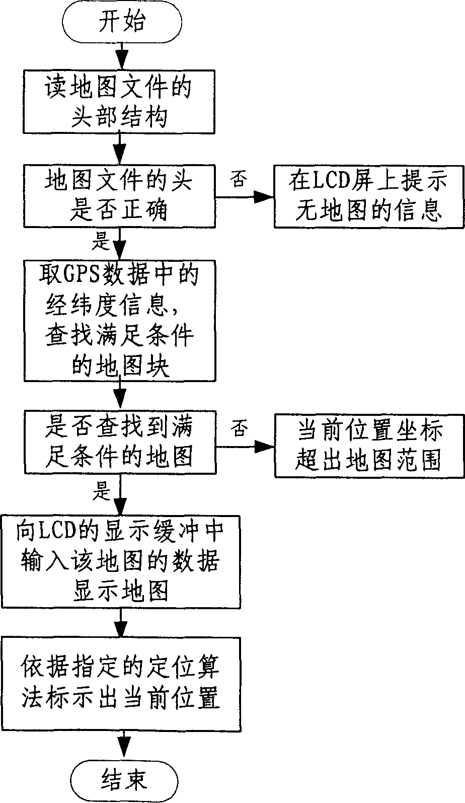
[0025] The dynamic display processing method of the grid electronic map is to display the grid electronic map based on the limited grayscale LCD screen in the mobile terminal. The method is carried out as follows: (1) select the map source, check the accuracy of the map source, and then view The characteristics of the source and the requirements of the user divide the source map, and mark the latitude and longitude coordinate range of each block, then pack the map content and latitude and longitude information data into an electronic grid map data file; (2) download the electronic grid map data file On the terminal, when the terminal receives the correct GPS signal, take out the current latitude and longitude information of the terminal from the signal, and compare this information with the latitude and longitude information of each map stored in the electronic grid map, obtain a m...


PUM


Abstract

This invention relates to a dynamic display process method for grating electron map, which comprises the following steps: a, choosing graph source and testing its accuracy and dividing it according to its characteristics and users demands and marking the latitude and longitude coordinates range and packing these information data into electronic grating map data files; b, downloading the map data files to the terminal to fetch the current information from signals when receiving the correct GPS signals and comparing the latitude and longitude information of each map stored in the electron grating maps to get one map and display it on the LCD screen and marking the current position according to the proportion on the map. This invention regulates the electron map operations and the usage and realizes the large range of display of the map and its position wizard function.

Description

technical field [0001] The invention relates to a processing method for dynamically displaying an electronic map in a vehicle and other equipment related to a grid electronic map, and coordinating with a global positioning system (GPS) for navigation and positioning. Background technique [0002] With the development of high technology and the automobile industry, positioning and navigation of automobiles through the Global Positioning System (GPS) has developed into a relatively large market. Generally speaking, the current high-end models, GPS navigation function has become standard. And now the positioning and navigation of cash transport vehicles, ambulances, fire engines, etc., real-time monitoring and other projects are also rapidly unfolding across the country. Electronic map is an essential part of positioning and navigation system. Compared with ordinary maps, electronic maps have many advantages: [0003] 1. It is convenient to inquire ab...

Claims


Application Information

Patent Timeline
Patent Type & Authority Applications(China)
IPC IPC(8): G01C21/26
Inventor 吴玲琦黄小方罗毅周训飞李华明
Owner WUHAN HONGXIN TELECOMM TECH CO LTD
Why Eureka
Try Eureka