Ground three-dimensional semantic map based on multi-aircraft cooperative flight and construction method thereof

A semantic map and construction method technology, applied in the field of surveying and mapping and unmanned aerial vehicles, can solve the problems of low work efficiency, time-consuming, single data, etc., and achieve the effect of improving efficiency

Pending Publication Date: 2022-02-25
AEROSPACE TIMES FEIHONG TECH CO LTD
View PDF6 Cites 2 Cited by
  • Summary
  • Abstract
  • Description
  • Claims
  • Application Information

AI Technical Summary

Problems solved by technology

[0004] The purpose of the present invention is to overcome at least one of the deficiencies of the prior art and provide a method for constructing a ground three-dimensional semantic map based on multi-aircraft cooperative flight. Technical issues, using multi-machine coordination technology, through the cooperation of different sensors carried by the UAV, the autonomous control of the aircraft, intelligent planning and multi-dimensional and efficient acquisition of spatial geographic data have been realized, and through processing The software processes aerial survey data to obtain thematic maps that meet different needs

Method used


Image

  • Ground three-dimensional semantic map based on multi-aircraft cooperative flight and construction method thereof
  • Ground three-dimensional semantic map based on multi-aircraft cooperative flight and construction method thereof
  • Ground three-dimensional semantic map based on multi-aircraft cooperative flight and construction method thereof

Examples


Embodiment Construction

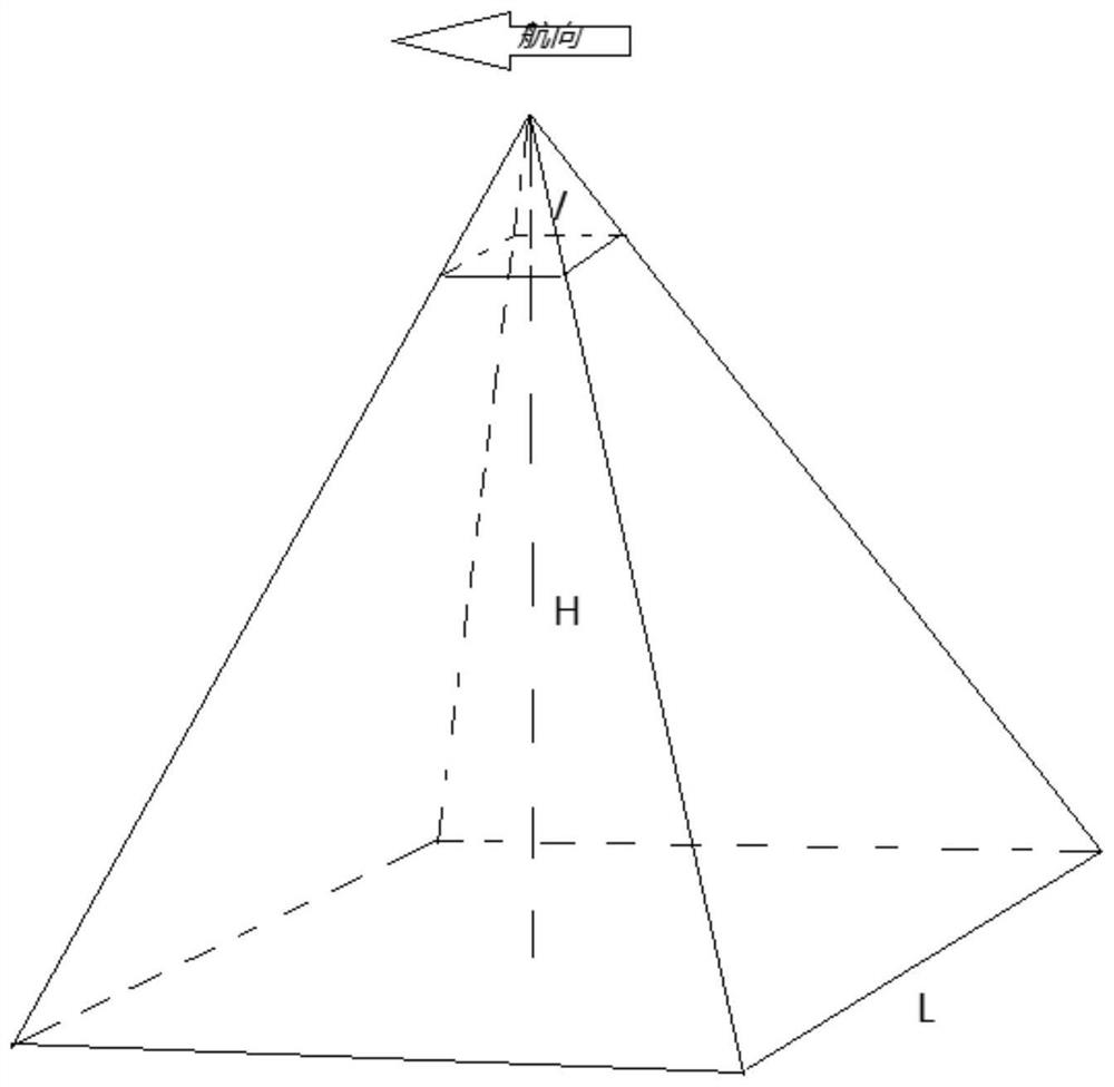
[0042] Specific embodiments of the present invention will be described in detail below in conjunction with specific drawings. It should be noted that the technical features or combinations of technical features described in the following embodiments should not be regarded as isolated, and they can be combined with each other to achieve better technical effects.

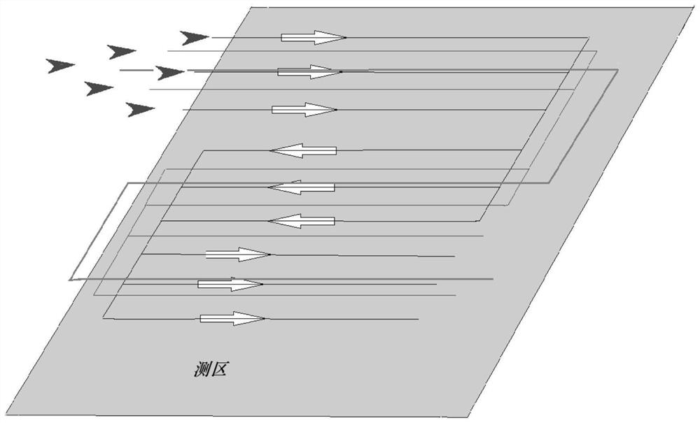
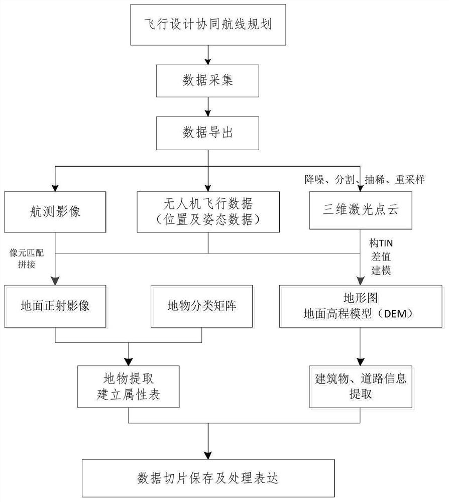
[0043]In the embodiment of the present invention, multiple unmanned aerial vehicles of different types are used to carry out cooperative flight by carrying different sensors to obtain the aerial survey data of the survey area and obtain various types of data required through subsequent data processing. Finally, all the measurement data and the acquired multiple The thematic maps were merged into a 3D semantic map database for the surveyed area. The embodiment of the present invention produces map data results through the following processes and steps: UAV collaborative flight design—UAV flight control and data collect...


PUM


Abstract

The invention relates to the technical field of surveying and mapping and unmanned aerial vehicles, and provides a ground three-dimensional semantic map based on multi-vehicle cooperative flight and a construction method thereof, and the method comprises the steps: selecting the types of sensors carried by the unmanned aerial vehicles according to task demands, and determining the number, formation mode and flight route of the unmanned aerial vehicles, the flight distance of each unmanned aerial vehicle and the flight height of each unmanned aerial vehicle; collecting data which includes ground measurement information in multiple dimensions, and aircraft attitude information and position information at all measurement moments; data preprocessing: unifying data from an image space coordinate system to an object space coordinate system; data processing: vectorizing the extracted different ground feature data, storing the vectorized data to different layers, and establishing an attribute table of different ground features; and data processing expression: overlapping different layers to obtain a three-dimensional semantic map. According to the invention, the defect that the aerial survey work at the present stage generally only obtains a single type of data and cannot obtain multiple types of data at the same time is overcome, and the identification of a three-dimensional semantic map and the multi-scene application of geographic space data can be met.

Description

technical field [0001] The invention relates to the technical fields of surveying and mapping and unmanned aerial vehicles, in particular to a method for constructing a ground three-dimensional semantic map based on multi-machine cooperative flight. Background technique [0002] With the rapid development of control technology and chips, the control accuracy of UAVs has been continuously improved, the flight cost has been gradually reduced, and the sensor accuracy has been continuously improved. The orderly low-altitude flight airspace makes UAV surveying and mapping a safe, cheap, high-performance, fast, and high-precision spatial data acquisition method in the future. However, the current UAV aerial survey application field generally uses a single aircraft and multiple sorties to complete the aerial survey work. In the face of emergency relief, air space tension and real-time aerial survey work, it takes a long time to complete the work, which cannot meet various requireme...

Claims


Application Information

Patent Timeline
Patent Type & Authority Applications(China)
IPC IPC(8): G05D1/12G01C21/00
CPCG05D1/12G01C21/3841
Inventor 师晓波段方郭育青沈祥立姜庭宇
Owner AEROSPACE TIMES FEIHONG TECH CO LTD
Why Eureka
Try Eureka