
Highway engineering GIS model and BIM model conversion and integration method

A technology of GIS-BIM and integrated methods, which is applied in the direction of structured data retrieval, special data processing applications, geometric CAD, etc., can solve problems affecting system performance and low conversion efficiency, and achieve guaranteed conversion efficiency, high conversion efficiency, and improved Effects of Truth and Accuracy

Pending Publication Date: 2022-01-04
CHINA RAILWAY SEVENTH GRP CO LTD +1
View PDF0 Cites 0 Cited by
  • Summary
  • Abstract
  • Description
  • Claims
  • Application Information

AI Technical Summary

Problems solved by technology

This method can add rich detailed information to the GIS model, but because the BIM model has rich semantic information, a large number of calculations will be generated during the conversion and import process, the conversion efficiency is low and it is easy to affect the system performance

Method used


Image

  • Highway engineering GIS model and BIM model conversion and integration method

Examples


Embodiment Construction

[0026] The present invention will be further described in detail below in conjunction with the accompanying drawings, so that those skilled in the art can implement it with reference to the description.

[0027] It should be noted that the experimental methods described in the following embodiments, unless otherwise specified, are conventional methods, and the reagents and materials, if not otherwise specified, can be obtained from commercial sources; in the description of the present invention, The terms "landscape", "portrait", "top", "bottom", "front", "rear", "left", "right", "vertical", "horizontal", "top", "bottom", The orientation or positional relationship indicated by "inner", "outer", etc. is based on the orientation or positional relationship shown in the drawings, which is only for the convenience of describing the present invention and simplifying the description, and does not indicate or imply that the referred device or element must have Certain orientations, co...


PUM


Abstract

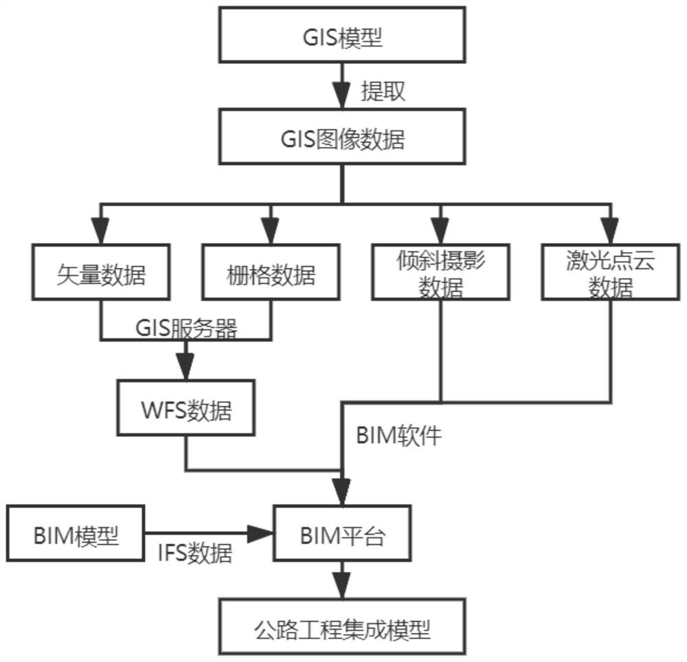
The invention discloses a highway engineering GIS model and BIM model conversion and integration method. The method comprises the steps of extracting GIS image data from a highway engineering GIS model; analyzing the GIS image information, and dividing the GIS image information into vector data, raster data, oblique photography data and laser point cloud data according to data types; respectively converting the four kinds of GIS data, and then importing into a BIM platform; importing the data of the highway engineering BIM model into the BIM platform; and integrating the IFS data and the converted GIS data by using the BIM platform to obtain a highway engineering integration model. According to the invention, various types of spatial data of the GIS model are classified and converted and then integrated into the platform where the BIM model is located, the spatial data is integrated with the standard data of the BIM model, the integrated model data are fused with the spatial information such as the surrounding environment data of the project main body, the construction process can be accurately simulated, the calculation amount of the conversion method is relatively small, and the conversion efficiency is high.

Description

technical field [0001] The present invention relates to fields. More specifically, the present invention relates to a method for converting and integrating highway engineering GIS models and BIM models. Background technique [0002] With the development of transportation technology, the construction difficulty of highway engineering construction is gradually increasing, especially in the construction of highway engineering with complex terrain, ruggedness and large span, the construction situation is greatly affected by the surrounding geographical and geological environment, and a single BIM Technology has been unable to meet the requirements of engineering quality and speed. GIS technology has large-scale macro-environmental data and analysis capabilities that BIM technology lacks, and the combination of GIS technology and BIM technology has gradually become an industry development trend. Due to the high openness of GIS data and the strong closeness of BIM data, when it ...

Claims


Application Information

Patent Timeline
Patent Type & Authority Applications(China)
IPC IPC(8): G06F30/13G06F16/29
CPCG06F30/13G06F16/29
Inventor 邢浩郭冬冬袁义华徐长友李瀚吴佳琪孙浩铭张明亮唐亚辉盛帅兵温建宇黄金伟张辉文李峰
Owner CHINA RAILWAY SEVENTH GRP CO LTD
Learn More