Method for determining 1985 elevation reference gravitational potential of China

A technology of gravity level and elevation, applied in the field of data surveying and mapping, can solve the problems of limited resolution, unrepresentative gravity field information, and difficulty in the shortcomings of the average sea surface coordinates of tide gauge stations, and achieves the effect of improving model accuracy and shortwave accuracy.

Pending Publication Date: 2021-10-26
NAT GEOMATICS CENT OF CHINA
View PDF0 Cites 0 Cited by
  • Summary
  • Abstract
  • Description
  • Claims
  • Application Information

AI Technical Summary

Problems solved by technology

[0010] This scheme has two main disadvantages. The first is that the average sea surface coordinates of tide gauge stations are difficult to
The second is that the local gravity field information using EGM2008 or EIGEN-6C4 gravity field model technology is not representative, and the resolution of these two models is limited

Method used


Image

  • Method for determining 1985 elevation reference gravitational potential of China
  • Method for determining 1985 elevation reference gravitational potential of China
  • Method for determining 1985 elevation reference gravitational potential of China

Examples


Embodiment Construction

[0034] In order to make the object, technical solution and advantages of the present invention clearer, the present invention will be further described in detail below in combination with specific embodiments and with reference to the accompanying drawings. It should be understood that these descriptions are exemplary only, and are not intended to limit the scope of the present invention. Also, in the following description, descriptions of well-known structures and techniques are omitted to avoid unnecessarily obscuring the concept of the present invention.

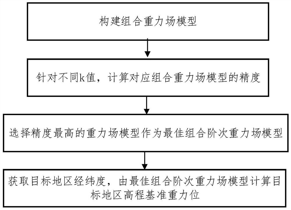
[0035] The invention provides a method for determining the gravity level of my country's 1985 elevation datum, combining figure 1 , including the following steps:

[0036] (1) Construct the combined gravity field model, the first k order adopts the corresponding order of the GRACE or COCE gravity field model, and the k-2190 order of the combined gravity field model adopts the corresponding order of the EGM2008 gravity fi...


PUM


Abstract

The invention relates to a method for determining the 1985 elevation reference gravitational potential of China, which comprises the following steps of constructing a combined gravitational field model, adopting the corresponding order of a GRACE / COCE gravitational field model for the first k orders, and adopting the corresponding order of an EGM2008 gravitational field model for the k-2190 orders of the combined gravitational field model, for different k values, calculating the precision of the corresponding combined gravitational field model, selecting the gravitational field model with the highest precision as an optimal combination order gravitational field model, obtaining the longitude and latitude of the target area, and calculating the elevation reference gravitational potential of the target area through the optimal combination order gravitational field model. According to the method, the combined gravitational field model is jointly constructed based on the GRACE or COCE gravitational field model and the EGM2008 gravitational field model, the short wave precision of the gravitational field model can be better improved, and the model precision is further improved. The optimal combined order gravitational field model is adopted to calculate the elevation reference gravitational potential of the target area, the elevation reference gravitational potential of China can be determined with higher precision, and effective unification of the 1985 elevation reference and the global elevation reference in China is achieved.

Description

technical field [0001] The invention relates to the technical field of data surveying and mapping, in particular to a method for determining the gravity level of my country's 1985 elevation datum. Background technique [0002] The unification of elevation datums is an important problem faced by geodesy and needs to be solved urgently after the unification of the global geodetic coordinate system and its reference datum. The main problem is to determine the vertical deviation between the local elevation datum and the global elevation datum. The global elevation datum is defined by the geoid, the gravitational equipotential surface that best fits the mean sea surface on a global scale. [0003] The elevation datum is the starting basis for the topographic elevation of a country or region, and is usually determined by the average sea level observed by one or more tide gauge stations for a long time. The average sea level is affected by many factors, such as tide station data, o...

Claims


Application Information

Patent Timeline
Patent Type & Authority Applications(China)
IPC IPC(8): G01V7/00
CPCG01V7/00
Inventor 李志才张盼盼鲍李峰张鹏王永尚
Owner NAT GEOMATICS CENT OF CHINA
Why Eureka
Try Eureka