
A method for autonomous location and landing of unmanned aerial vehicles integrating lidar point cloud and image data

A technology of image data and drones, applied in radio wave measurement systems, instruments, control/regulation systems, etc., can solve problems such as unsafe landing of drones, complex operating environment, loss of drone signals, etc. It is not easy to achieve The effect of external light interference, ensuring high-altitude operations, and fast and effective screening

Active Publication Date: 2022-07-29
FUJIAN UNIV OF TECH
View PDF8 Cites 0 Cited by
  • Summary
  • Abstract
  • Description
  • Claims
  • Application Information

AI Technical Summary

Problems solved by technology

And in the process of automatic landing, due to the complex operating environment of the UAV and the uneven terrain, it will lead to the loss of the UAV signal, inaccurate positioning, incomplete terrain modeling and other problems, resulting in the inability of the UAV to land safely.

Method used


Image

  • A method for autonomous location and landing of unmanned aerial vehicles integrating lidar point cloud and image data
  • A method for autonomous location and landing of unmanned aerial vehicles integrating lidar point cloud and image data
  • A method for autonomous location and landing of unmanned aerial vehicles integrating lidar point cloud and image data

Examples


Embodiment Construction

[0045] The technical solutions in the embodiments of the present application will be clearly and completely described below with reference to the accompanying drawings in the embodiments of the present application.

[0046] In the following introduction, the terms "first" and "second" are used for descriptive purposes only, and should not be construed as indicating or implying relative importance. The following description provides multiple embodiments of the present application, and different embodiments may be substituted or combined, so the present application may also be considered to include all possible combinations of the same and / or different embodiments described. Thus, if one embodiment includes features A, B, C and another embodiment includes features B, D, the application should also be considered to include all other possible combinations of one or more of A, B, C, D example, although this example may not be explicitly described in the following content.

[0047]...


PUM


Abstract

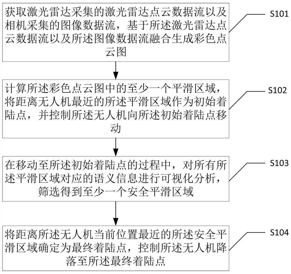
The invention discloses a method for autonomous site selection and landing of an unmanned aerial vehicle integrating LIDAR point cloud and image data. The method includes generating a color point cloud image based on the fusion of lidar point cloud data stream and image data stream; calculating at least one smooth area in the color point cloud image, taking the smooth area closest to the UAV as the initial landing point, and controlling the UAV Move to the initial landing point; in the process of moving to the initial landing point, perform visual analysis on the semantic information corresponding to all smooth areas, and filter to obtain at least one safe smooth area; determine the safe smooth area closest to the current position of the drone as The final landing point, control the drone to land to the final landing point. The invention realizes that without relying on unreliable sensor information such as GPS and IMU, the optimal landing point in the area is independently selected for landing over various terrains, and the landing point with potential safety hazard can be quickly and effectively screened.

Description

technical field [0001] The present application relates to the technical field of automatic control of unmanned aerial vehicles, and in particular, to a method for autonomous site selection and landing of unmanned aerial vehicles integrating LIDAR point cloud and image data. Background technique [0002] As a representative of unmanned aerial vehicles, rotary-wing UAVs have the advantages of vertical take-off and landing, free hovering, and flexible control, and have huge application prospects in the fields of military warfare, resource detection and disaster rescue. At present, the development process of UAV technology is divided into seven stages in the industry. The current technology is between the fifth and sixth stages, that is, UAVs have payload adaptability and certain automatic driving capabilities, and autonomous landing requires UAVs to complete After the mission, the appropriate landing site is automatically selected for landing recovery while considering energy c...

Claims


Application Information

Patent Timeline
Patent Type & Authority Patents(China)
IPC IPC(8): G05D1/06G01S7/48
CPCG05D1/0676G01S7/4802
Inventor 邹诚李灵峰孔令华
Owner FUJIAN UNIV OF TECH
Learn More