Municipal engineering surveying and mapping system and use method thereof

An engineering and municipal technology, applied in the field of municipal engineering surveying and mapping systems, can solve the problems of increasing the workload of staff, labor costs, occupying storage space, etc., to reduce the risk of injury, facilitate use and storage, and reduce storage area. Effect

Inactive Publication Date: 2021-09-07
曹靖崧
View PDF0 Cites 0 Cited by
  • Summary
  • Abstract
  • Description
  • Claims
  • Application Information

AI Technical Summary

Problems solved by technology

[0002] Engineering surveying and mapping mainly studies the basic theories and technologies of space, electronics, information, laser, inertia and other sciences, and studies the use of these technologies to determine the shape of the earth and other stars, the three-dimensional characteristics of buildings and their relationship with the designated reference system, and the earth's gravity field And its internal physical characteristics, the characteristics of moving objects and its multi-dimensional parameters, so the surveying and mapping work basically needs a working team to complete. The communication of ordinary staff depends on the phone, which will be affected by other factors and affect the work progress. At the same time, the staff must Measuring and drawing the road topography requires two or more workers to work together, and the labor cost is high. At the same time, the carrying of tools will occupy a certain amount of storage space and increase the burden on the workers.

Method used


Image

  • Municipal engineering surveying and mapping system and use method thereof
  • Municipal engineering surveying and mapping system and use method thereof
  • Municipal engineering surveying and mapping system and use method thereof

Examples


Embodiment Construction

[0030] In the description of the present invention, it should be noted that the orientations or positional relationships indicated by the terms "upper", "lower", "inner", "outer", "top / bottom" etc. are based on the orientations shown in the drawings Or positional relationship is only for the convenience of describing the present invention and simplifying the description, but does not indicate or imply that the device or element referred to must have a specific orientation, be constructed and operated in a specific orientation, and therefore should not be construed as limiting the present invention. In addition, the terms "first" and "second" are used for descriptive purposes only, and should not be understood as indicating or implying relative importance.

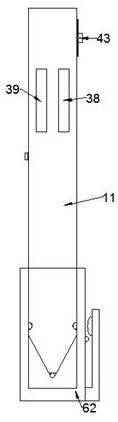
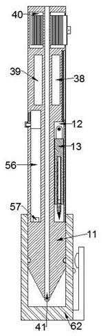
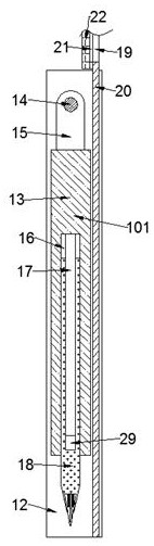
[0031] refer to Figure 1-9 , a municipal engineering surveying and mapping system according to an embodiment of the present invention, comprising a pen housing 11 and a cover housing 62 detachably connected to the pen hous...


PUM


Abstract

The invention discloses a municipal engineering surveying and mapping system and a use method thereof. The municipal engineering surveying and mapping system comprises a pen shell and a cover shell detachably connected to the pen shell, a detachably connected refill is arranged in the pen shell, and a compass groove with an outward opening is formed in the position, located on the right side of the refill, in the pen shell; the compasses device is arranged in the compasses device, circle drawing can be assisted in the drawing and filling process of a user, the compasses device and the whole device are designed together to facilitate use and storage, the storage area is reduced, and the problem that the user forgets to carry the compasses device is solved; the positioning device is arranged in the pen, the walking track and distance can be preliminarily displayed on the displayer according to the walking route of a user carrying a pen, the actual route can be conveniently measured and drawn later, and the pen is simple in structure, small and exquisite in design and convenient to carry; and a voice function is arranged in the device, a user can communicate with long-distance colleagues through the device, the working efficiency is improved, and work is assisted.

Description

technical field [0001] The invention relates to the technical field of municipal engineering surveying and mapping systems, in particular to a municipal engineering surveying and mapping system and a method for using the same. Background technique [0002] Engineering surveying and mapping mainly studies the basic theories and technologies of space, electronics, information, laser, inertia and other sciences, and studies the use of these technologies to determine the shape of the earth and other stars, the three-dimensional characteristics of buildings and their relationship with the designated reference system, and the earth's gravity field And its internal physical characteristics, the characteristics of moving objects and its multi-dimensional parameters, so the surveying and mapping work basically needs a working team to complete. The communication of ordinary staff depends on the phone, which will be affected by other factors and affect the work progress. At the same tim...

Claims


Application Information

Patent Timeline
Patent Type & Authority Applications(China)
IPC IPC(8): G01C15/00G01C7/02B43L9/02B43L9/16B43L9/24B43K29/00
CPCG01C15/00G01C7/02B43L9/02B43L9/16B43L9/24B43K29/00
Inventor 曹靖崧
Owner 曹靖崧
Why Eureka
Try Eureka