BIM + GIS multi-source data fusion processing method and system

A technology of fusion processing and multi-source data, applied in electrical digital data processing, special data processing applications, database updating, etc., can solve the problems of inability to detect the latest data in real time, slow data map update speed, waste of staff time, etc. Convenient daily travel, data processing speed optimization, time-saving effect

Pending Publication Date: 2021-07-02
慧图信息科技有限公司
View PDF1 Cites 2 Cited by
  • Summary
  • Abstract
  • Description
  • Claims
  • Application Information

AI Technical Summary

Problems solved by technology

[0002] After retrieval, Chinese Patent No. CN111459953A discloses a map matching update method and system for multi-source data fusion. Although the invention can update multi-source data to offline maps, it cannot update the data in real time. Multi-source data fusion technology is practical It refers to the use of relevant means to integrate all the information obtained through investigation and analysis, to make a unified evaluation of the information, and finally to obtain unified geological body information. The purpose of this technology is to comprehensively absorb various data and information. The characteristics of the source and then extract unified, better and richer information than a single data. BIM is the building information model. Its core is to provide a complete, The construction engineering information database that is consistent with the actual situation provides a platform for engineering information exchange and sharing for the stakeholders of the construction project, and plays an important role in improving production efficiency, saving costs and shortening the construction period. GIS is a geographic information system. A data management system with a professional form of information system space, which represents the objective objects of the real world in the form of digital data. The objective objects of the real world can be divided into two abstract concepts: discrete objects and continuous object fields. These two abstractions The two main methods for storing data in the GIS system are raster and vector. With the changes of the times, data maps have gradually become one of the indispensable tools for people to go out. The real-time update of data maps has become particularly important. BIM +Continuous development and optimization of GIS multi-source data fusion processing methods and systems;
[0003] The existing BIM+GIS multi-source data fusion processing method and system cannot detect the latest data in real time, resulting in slow update of the data map, which easily affects people's travel and affects people's use. Secondly, the existing BIM+GIS multi-source data fusion The processing method and system fusion data will produce some errors, which require staff to check and repair, which wastes staff time and reduces work efficiency; for this reason, we propose a BIM+GIS multi-source data fusion processing method and system

Method used


Image

  • BIM + GIS multi-source data fusion processing method and system
  • BIM + GIS multi-source data fusion processing method and system

Examples


Embodiment Construction

[0043] The following will clearly and completely describe the technical solutions in the embodiments of the present invention with reference to the accompanying drawings in the embodiments of the present invention. Obviously, the described embodiments are only some, not all, embodiments of the present invention.

[0044] In describing the present invention, it should be understood that the terms "upper", "lower", "front", "rear", "left", "right", "top", "bottom", "inner", " The orientation or positional relationship indicated by "outside", etc. is based on the orientation or positional relationship shown in the drawings, and is only for the convenience of describing the present invention and simplifying the description, rather than indicating or implying that the referred device or element must have a specific orientation, so as to Specific orientation configurations and operations, therefore, are not to be construed as limitations on the invention.

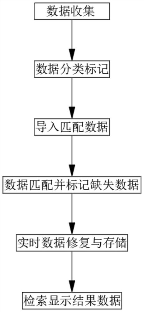
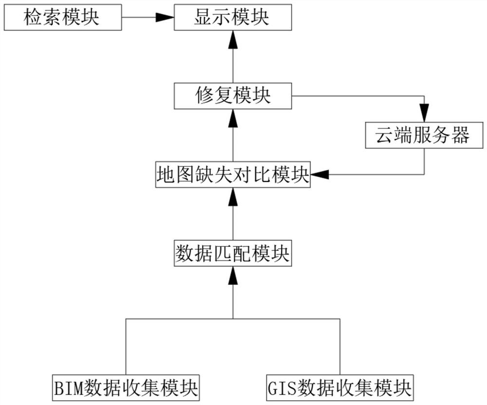
[0045] refer to Figure ...


PUM


Abstract

The invention discloses a BIM + GIS multi-source data fusion processing method and system, and belongs to the technical field of multi-source data fusion. The multi-source data fusion method comprises the following specific steps: (1) data collection; (2) data classification marking; (3) exporting fused data; (4) carrying out data matching and marking missing data; (5) repairing and storing real-time data; (6) retrieving and displaying result data; the repair module receives the basic repair data and the fusion data and then performs data fusion on the two groups of data, and part of data in the fusion data is replaced with the repair data, so that the error probability generated by data fusion is reduced, the time of workers is saved, the working efficiency is improved, and the updating speed of a data map is increased; the error rate of the data map is reduced, and daily travel of people is facilitated.

Description

technical field [0001] The invention relates to the technical field of multi-source data fusion, in particular to a BIM+GIS multi-source data fusion processing method and system. Background technique [0002] After retrieval, Chinese Patent No. CN111459953A discloses a map matching update method and system for multi-source data fusion. Although the invention can update multi-source data to offline maps, it cannot update the data in real time. Multi-source data fusion technology is practical It refers to the use of relevant means to integrate all the information obtained through investigation and analysis, to make a unified evaluation of the information, and finally to obtain unified geological body information. The purpose of this technology is to comprehensively absorb various data and information. The characteristics of the source and then extract unified, better and richer information than a single data. BIM is the building information model. Its core is to provide a comp...

Claims


Application Information

Patent Timeline
Patent Type & Authority Applications(China)
IPC IPC(8): G06F16/215G06F16/23G06F16/29
CPCG06F16/215G06F16/2379G06F16/29
Inventor 武晓宁李印锋宁兴伟杨勇
Owner 慧图信息科技有限公司
Why Eureka
Try Eureka