Remote sensing image visible light wave band terrain shadow correction method

A technology of remote sensing image and correction method, which is applied in the direction of image detector method and image signal processing, material analysis through optical means, re-radiation of electromagnetic waves, etc. Poor and other problems, to make up for the effect of falling shadow failure

Active Publication Date: 2021-06-15
FUZHOU UNIV
View PDF9 Cites 0 Cited by
  • Summary
  • Abstract
  • Description
  • Claims
  • Application Information

AI Technical Summary

Problems solved by technology

The method based on the mountain radiative transfer model considers direct solar radiation, atmospheric diffuse radiation and surrounding terrain reflection radiation at the same time.
The empirical correction method based on DEM data is based on the statistical relationship between reflectance and cosi, including statistical-empirical model, normalization model, Lambertian body reflectivity model and non-Lambert body reflectivity model, but this type The method is only effective for the umbra, and the correction effect for the falling shadow is not good
The method based on the band combination optimization calculation model obtains the vegetation information after removing the influence of terrain by constructing a special vegetation index, such as band ratio model, FCD model and VBSI index, terrain-adjusted vegetation index, normalized difference mountain vegetation index, shadow Eliminate Vegetation Index (SEVI), etc. However, this type of model can only obtain the index information of falling shadows, and lacks multispectral information

Method used


Image

  • Remote sensing image visible light wave band terrain shadow correction method
  • Remote sensing image visible light wave band terrain shadow correction method
  • Remote sensing image visible light wave band terrain shadow correction method

Examples


Embodiment Construction

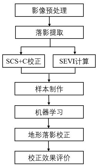
[0060] The present invention will be further described below with reference to the accompanying drawings and embodiments.

[0061] Please refer to figure 1 , the present invention provides a method for correcting remote sensing images of visible light band terrain fall, comprising the following steps:

[0062] Step S1: acquiring data and preprocessing, the required data includes: satellite remote sensing data and DEM data. Perform radiometric calibration and atmospheric correction on the satellite remote sensing data, use the mask file of the study area to trim the surface reflectance data after atmospheric correction, and obtain the surface reflectance data in the study area. DEM data in the study area, and finally standardize the acquired data into the same data format;

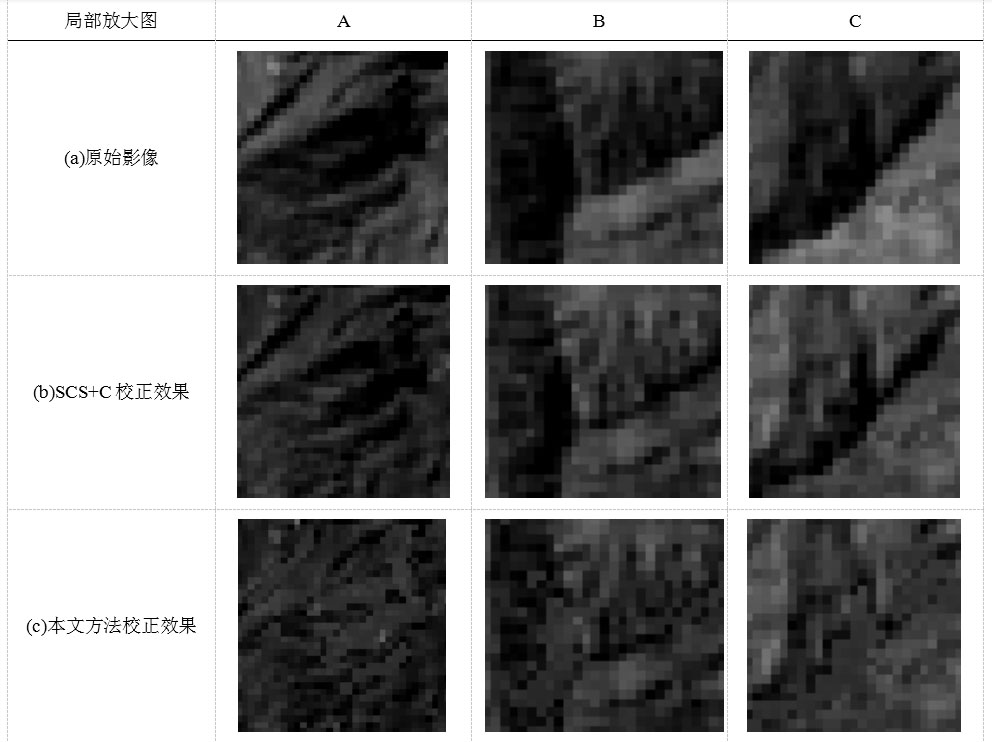
[0063] Step S2: Falling shadow extraction, first extracting the overall shadow, then extracting the umbra, and finally making the difference between the overall shadow and the umbra to extract the falling s...


PUM


Abstract

The invention relates to a remote sensing image visible light wave band terrain shadow correction method. The method mainly comprises the steps of image preprocessing, shadow extraction, SCS+C calculation, SEVI calculation, sample making, machine learning, terrain shadow correction and terrain shadow correction effect evaluation. According to the remote sensing image visible light wave band terrain shadow method, the shadow interference of red, green and blue wave bands of the remote sensing image can be effectively eliminated, the defect that the SEVI can only obtain single-wave band information for eliminating the shadow interference is overcome, and the defect that a conventional terrain correction method based on the DEM fails in shadow is further overcome.

Description

technical field [0001] The invention relates to the technical field of shadow compensation, in particular to a method for correcting terrain shadows in the visible light band of remote sensing images. Background technique [0002] Terrain shadows seriously interfere with the accuracy of vegetation information extraction in mountainous areas, and cause great difficulties in the interpretation of mountain land cover. Therefore, it is of great significance to study the compensation method of terrain shadow spectral information. The current terrain shading correction methods mainly include three types: mountain radiative transfer model, empirical correction model based on DEM data, and band combination optimization calculation model. The method based on the mountain radiation transfer model also considers the direct solar radiation, the atmospheric scattered radiation and the reflected radiation from the surrounding terrain. Empirical correction methods based on DEM data perfor...

Claims


Application Information

Patent Timeline
Patent Type & Authority Applications(China)
IPC IPC(8): G01N21/17G01S7/497G01S17/89G06K9/36G06K9/00G06K9/62
CPCG01N21/17G01S7/497G01S17/89G01N2021/1795G01N2021/1797G01N2021/1765G01N2201/1215G01N2201/121G06V20/13G06V10/247G06V10/20G06F18/24323
Inventor 江洪吴勇锋麻霞
Owner FUZHOU UNIV
Why Eureka
Try Eureka