Optimization method, server, client and system based on administrative region map
A technology of administrative areas and optimization methods, applied in the field of image processing, can solve the problem that the echarts map example cannot realize the customization requirements of provincial and municipal maps, and achieve the effect of improving user experience, optimizing outline, and enhancing three-dimensional sense.
- Summary
- Abstract
- Description
- Claims
- Application Information
AI Technical Summary
Problems solved by technology
Method used
Image

Examples
Embodiment 1
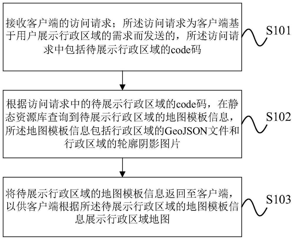
[0053] Such as figure 1 As shown, the embodiment of the present invention provides an optimization method based on the administrative area map, which is applied to the server, and the method includes:
[0054] S101: Receive an access request from the client; the access request is sent by the client based on the user's demand for displaying the administrative area, and the access request includes the code of the administrative area to be displayed;
[0055] S102: According to the code code of the administrative area to be displayed in the access request, query the map template information of the administrative area to be displayed in the static resource library, the map template information includes the GeoJSON file of the administrative area and the outline shadow picture of the administrative area;
[0056] Specifically, in practical applications, the static resource library is pre-built and stored on the server.
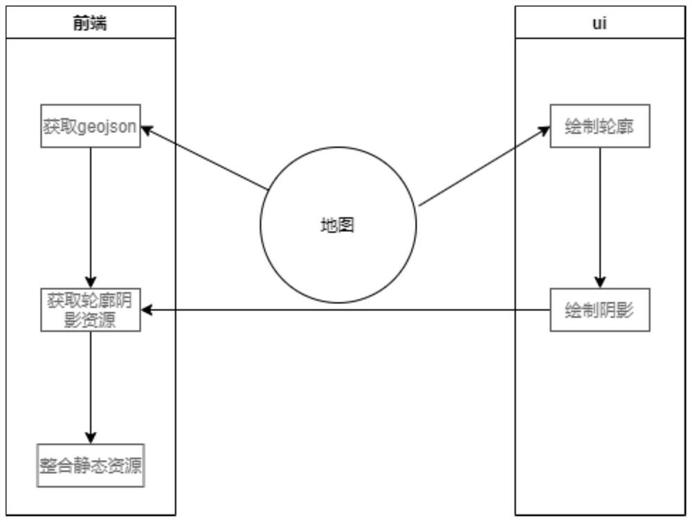
[0057] As a possible implementation, such as figure 2 As s...
Embodiment 2
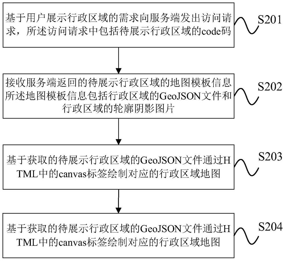
[0064] Such as image 3 As shown, the embodiment of the present invention also provides an optimization method based on the administrative area map, which is applied to the client, and the method includes:
[0065] S201: Send an access request to the server based on the user's demand for displaying the administrative area, and the access request includes the code of the administrative area to be displayed;
[0066] S202: Receive the map template information of the administrative area to be displayed returned by the server, the map template information includes the GeoJSON file of the administrative area and the outline shadow image of the administrative area;
[0067] S203: Based on the obtained GeoJSON file of the administrative area to be displayed, the corresponding administrative area map is drawn through the canvas tag in the HTML;
[0068] S204: Accurately fit the obtained outline shadow picture of the administrative area to be displayed on the drawn administrative area...
Embodiment 3
[0081] Such as Figure 5 As shown, the embodiment of the present invention provides an optimization server based on the administrative area map, including: a receiving module, a query module and a response module; wherein:
[0082] The receiving module receives an access request from the client; the access request is sent by the client based on the user's demand for displaying the administrative area, and the access request includes the code of the administrative area to be displayed. According to the code code of the administrative area to be displayed in the access request, the query module queries the map template information of the administrative area to be displayed in the static resource library. The map template information includes the GeoJSON file of the administrative area and the outline shadow picture of the administrative area. The response module returns the map template information of the administrative area to be displayed to the client, so that the client can ...
PUM
 Abstract
Description
Claims
Application Information
 - R&D
- Intellectual Property
- Life Sciences
- Materials
- Tech Scout
- Unparalleled Data Quality
- Higher Quality Content
- 60% Fewer Hallucinations
Browse by: Latest US Patents, China's latest patents, Technical Efficacy Thesaurus, Application Domain, Technology Topic, Popular Technical Reports.
© 2025 PatSnap. All rights reserved.Legal|Privacy policy|Modern Slavery Act Transparency Statement|Sitemap|About US| Contact US: help@patsnap.com