Real-time flight path planning method based on multi-sensor unmanned aerial vehicle

A track planning and multi-sensor technology, applied in the direction of instruments, three-dimensional position/channel control, non-electric variable control, etc., can solve the problems of redundancy, waste of planning time, and reduce the real-time performance of algorithms, etc. Conciseness, the effect of improving real-time performance and optimality

Active Publication Date: 2021-05-14
NANJING UNIV OF POSTS & TELECOMM
View PDF3 Cites 0 Cited by
  • Summary
  • Abstract
  • Description
  • Claims
  • Application Information

AI Technical Summary

Problems solved by technology

The random search generates the extended direction point q-rand, although it is beneficial for the algorithm to search for unknown areas, but this blind search method will generate a lot of redundancy, waste planning time, and reduce the real-time performance of the algorithm

Method used


Image

  • Real-time flight path planning method based on multi-sensor unmanned aerial vehicle
  • Real-time flight path planning method based on multi-sensor unmanned aerial vehicle
  • Real-time flight path planning method based on multi-sensor unmanned aerial vehicle

Examples


Embodiment Construction

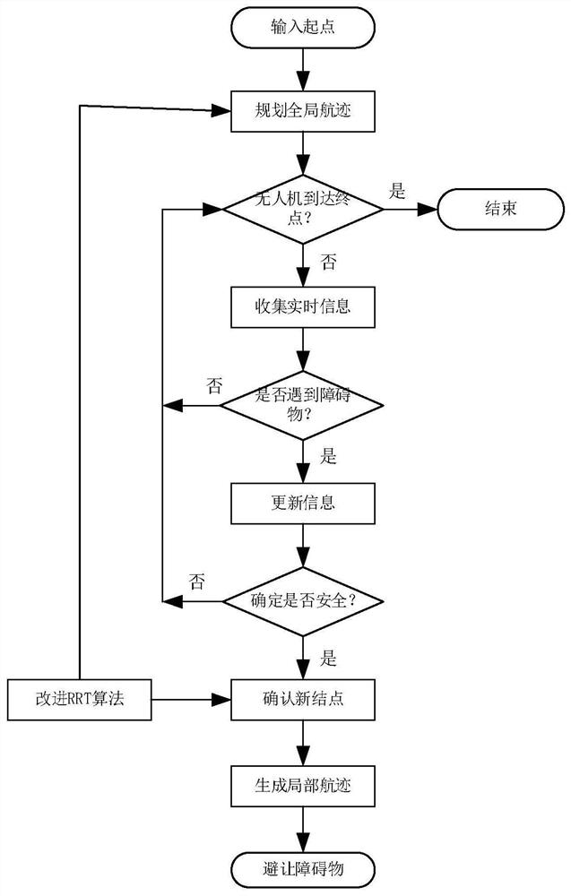
[0036] Such as figure 1 Shown, a kind of method based on the real-time track planning of multi-sensor unmanned aerial vehicle described in the present invention, its step comprises:

[0037] S1. Establish a mathematical model for UAV trajectory planning, input the starting point, and plan the global trajectory;

[0038] S2. Judging whether the UAV has reached the end point, if it reaches the end point, then end the flight mission; if it does not reach the end point, then proceed to S3;

[0039] S3. The UAV collects real-time information and detects whether there is an obstacle on the forward track. If not, proceed to S2. If so, update the information;

[0040] S4. Improve the RRT algorithm to sample new nodes, generate local tracks, and avoid obstacles.

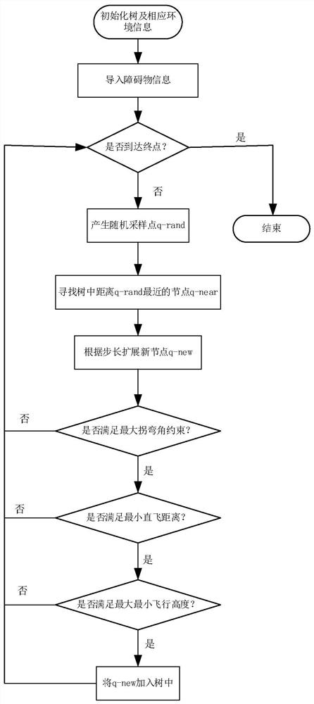
[0041] Such as image 3 As shown, the improved RRT algorithm is used to sample nodes, and the steps are:

[0042] S4-1. Search for nodes, initialize the tree and corresponding environment information, import the informati...


PUM


Abstract

The invention relates to a real-time flight path planning method based on a multi-sensor unmanned aerial vehicle, which comprises the following steps of firstly, establishing a mathematical model and a global flight path of flight path planning of the unmanned aerial vehicle, then, improving a fast random extension tree according to collected real-time information and whether an obstacle is encountered or not, and performing probability guidance on a generated random sampling point, and finally, applying the new algorithm to the flight path planning problem of the unmanned aerial vehicle. Finally, the navigation cost of the unmanned aerial vehicle is reduced, and the optimal path can be planned in real time by the unmanned aerial vehicle in a copying environment.

Description

technical field [0001] The invention relates to the technical field of unmanned aerial vehicle track planning, in particular to a method for real-time track planning based on multi-sensor unmanned aerial vehicles. Background technique [0002] In recent years, the application of UAVs has attracted more and more attention from scientific researchers. In a large forest fire, when the firefighters cannot approach, the UAV is equipped with multi-sensors to carry out some effective rescue, and the application in this aspect has attracted more and more attention. Because the UAV itself has a short battery life and the wireless sensors carried by the network are limited by the transmission distance of the network, the navigation requirements of the UAV must be optimal. Therefore, the optimization and real-time performance of the UAV track is proposed Require. The trajectory of UAV can be divided into local trajectory planning and global trajectory planning. The global trajectory...

Claims


Application Information

Patent Timeline
Patent Type & Authority Applications(China)
IPC IPC(8): G05D1/08G05D1/10
CPCG05D1/0808G05D1/101
Inventor 徐鹤孟秋云王汝传李鹏朱枫沙超程海涛
Owner NANJING UNIV OF POSTS & TELECOMM
Why Eureka
Try Eureka