
Satellite remote sensing technology-based planting insurance precise underwriting method

A technology of satellite remote sensing and technology, applied in image data processing, instruments, finance, etc., can solve the problems of inaccurate positioning and the degree of refinement needs to be improved, and achieve the effect of avoiding false underwriting

Pending Publication Date: 2021-04-30
中科禾信遥感科技(苏州)有限公司 +1
View PDF0 Cites 1 Cited by
  • Summary
  • Abstract
  • Description
  • Claims
  • Application Information

AI Technical Summary

Problems solved by technology

This remote sensing application method on a regional scale cannot accurately locate the actual planting plot of the policyholder, and the degree of refinement needs to be improved

Method used


Image

  • Satellite remote sensing technology-based planting insurance precise underwriting method
  • Satellite remote sensing technology-based planting insurance precise underwriting method

Examples


Embodiment

[0062]The technical solutions of the present invention will be explained and explained in the following use of the rice precipiture of rice in Jinhu County.

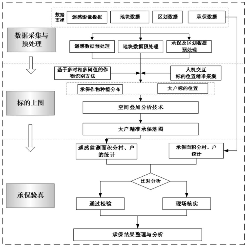
[0063]The implementation process of this embodiment is likefigure 1 As shown, the details of each part are as follows.

[0064]Firstly, the planting area and planting area of ​​rice are identified by remote sensing images from January to 8 months, and the statistical area of ​​the village is divided into the town. The identified rice and plot data superimposed analysis, obtaining rice planting plots, by comparing, verify the area of ​​large household coverage, and the verification, the pass verification, not guaranteed and needed Farmers inspected on site. Specifically, the following steps:

[0065](1) Data Acquisition and Preparation:

[0066](1-1) Data Acquisition

[0067]Data include remote sensing satellite images, administrative district demarcation lines, farmers underwriting information, and block data.

[0068]Among them, remote sensing...


PUM


Abstract

The invention provides a satellite remote sensing technology-based planting insurance precise underwriting method. The method comprises the steps of data acquisition and preprocessing, crop remote sensing monitoring, plotting and underwriting verification. According to the method, a remote sensing technology is introduced, a precise underwriting method based on a 'plot' scale is formed based on multi-source and multi-spectral remote sensing data, plot data and agricultural insurance underwriting data, agricultural insurance 'underwrite according to graphs' is formed, the underwriting precision is remarkably improved, the underwriting coverage is promoted to be improved, underwriting authenticity control is enhanced, and the agricultural insurance fine underwriting level is improved.

Description

Technical field[0001]The present invention belongs to the field of agricultural insurance, and specifically, it is specifically involved in the precision underwriting method based on satellite remote sensing technology.Background technique[0002]China is an agricultural big country. In 2017, agricultural insurance provided Risk protection, paying the compensation of 33.4 billion yuan, 47.37 million poor households and affected farmers benefit. Agricultural insurance compensation has become an important source of funds for the reconstruction of production and the reconstruction of farmers. The risk guarantee and economic compensation role are increasingly highlighted. However, with the expansion of agricultural insurance, agricultural insurance operations may face crop type, plant area, risk characteristics, etc. in front of the underwriting area, etc., and it is difficult to accurately determine the location and area of ​​the underwriting block when the underwritment is underwriting....

Claims


Application Information

Patent Timeline
IPC IPC(8): G06Q40/08G06Q50/02G06T7/62G06K9/00G06K9/62
CPCG06Q40/08G06Q50/02G06T7/62G06T2207/10036G06V20/188G06F18/24323
Inventor 徐飞飞陆洲罗明赵晨梁爽
Owner 中科禾信遥感科技(苏州)有限公司
Learn More