Complex region large-scale topographic map unmanned aerial vehicle close-range photogrammetric mapping system

A technology of close-range photography and unmanned aerial vehicles, which is applied in the field of surveying and mapping, can solve the problems of complex landforms in surveying areas, no safety guarantee for surveying and mapping personnel, and large ups and downs

Pending Publication Date: 2021-04-20
陕西誉泽工程咨询有限公司
View PDF9 Cites 0 Cited by
  • Summary
  • Abstract
  • Description
  • Claims
  • Application Information

AI Technical Summary

Problems solved by technology

[0005] Existing topographic maps mainly obtain topographic data through manual operation of total stations or scales, and then use vector-aided design software to manually draw topographic maps with the measured data, and use contour line elevation labeling to represent topographic features. Drawing on topographic maps, but the current problems encountered in large-scale topographic map surveying in complex areas: 1. There is no mobile data transmission signal in the survey area; 2. The height difference in the survey area is large (the height difference exceeds 300 meters); 3. The landform of the area is complex, with large ups and downs and steep terrain; 4. There is no safety guarantee for surveying and mapping personnel; 5. The internal data information obtained is extremely limited; 6. The data information has large errors and poor accuracy; 7. Human, financial and material resources and time investment

Method used


Image

  • Complex region large-scale topographic map unmanned aerial vehicle close-range photogrammetric mapping system
  • Complex region large-scale topographic map unmanned aerial vehicle close-range photogrammetric mapping system

Examples


Embodiment Construction

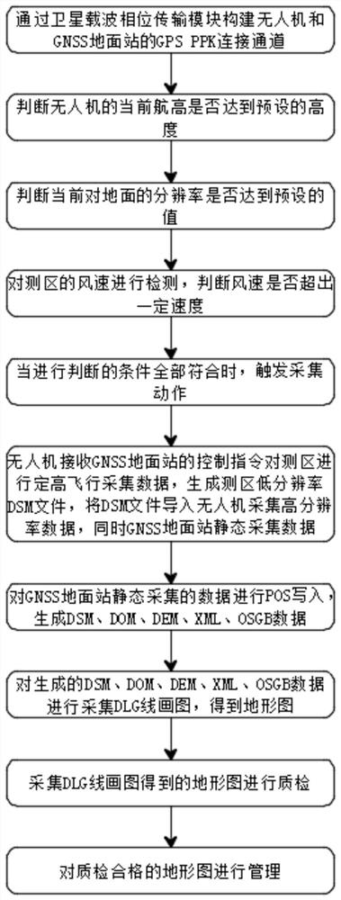
[0035] The following will clearly and completely describe the technical solutions in the embodiments of the present invention in combination with the embodiments of the present invention. Obviously, the described embodiments are only some of the embodiments of the present invention, not all of them. Based on the embodiments of the present invention, all other embodiments obtained by persons of ordinary skill in the art without making creative efforts belong to the protection scope of the present invention.

[0036] see figure 1 and figure 2 , the present invention provides a technical solution:

[0037] A UAV close-range photogrammetry system for large-scale topographic maps in complex areas, including a satellite carrier phase transmission module, an acquisition module, a processing module, an editing module, a quality inspection module, a result management module, a judgment module and a wind speed detection module.

[0038] The satellite carrier phase transmission module...


PUM


Abstract

The invention discloses a complex region large-scale topographic map unmanned aerial vehicle close-range photogrammetric mapping system, which comprises a satellite carrier phase transmission module, an acquisition module, a processing module, an editing module, a quality inspection module and an achievement management module, wherein the acquisition module is arranged on an unmanned aerial vehicle and a GNSS ground station, the processing module is connected with the acquisition module, the editing module is connected with the processing module, the quality inspection module is connected with the editing module, and the achievement management module is connected with the quality inspection module. The invention further provides a complex region large-scale topographic map unmanned aerial vehicle close-range photogrammetric mapping method. A stable mapping system can be formed, the whole surveying and mapping result is more accurate, the technical problem that a large-scale topographic map of a complex region cannot be precisely drawn and restored manually in the prior art is solved through combined use of multiple modules, and the function of precisely drawing and restoring the topographic map is achieved.

Description

technical field [0001] The invention relates to the technical field of surveying and mapping, in particular to an unmanned aerial vehicle close-range photogrammetry system for large-scale topographic maps in complex areas. Background technique [0002] Surveying and mapping refers to the measurement, collection and drawing of the shape, size, spatial location and attributes of natural geographical elements or surface artificial facilities. [0003] Surveying is also called surveying. It includes two main contents of measurement and mapping. Surveying and mapping is widely used in economic construction and national defense construction. In urban and rural construction planning, land resource utilization, environmental protection, etc., it is necessary to carry out land surveying and surveying and mapping of various maps for planning and management purposes. In the construction of geological exploration, mineral development, water conservancy, transportation, etc., it is ne...

Claims


Application Information

Patent Timeline
Patent Type & Authority Applications(China)
IPC IPC(8): G01C11/00H04B7/185
Inventor 陈律杨严亮韩栋田娟
Owner 陕西誉泽工程咨询有限公司
Why Eureka
Try Eureka