
Topographic surveying and mapping device with marking function

A technology for topographic mapping and marking functions, which is applied in the directions of measurement devices, mapping and navigation, measurement point marking, etc. It can solve the problems of inability to map point marking, troublesome horizontal calibration, and prone to bumps, etc., to achieve simple horizontal calibration and ensure stability. , the effect of easy disassembly

Pending Publication Date: 2021-02-23
HENAN UNIV OF URBAN CONSTR
View PDF2 Cites 5 Cited by
  • Summary
  • Abstract
  • Description
  • Claims
  • Application Information

AI Technical Summary

Problems solved by technology

[0003] At present, there are still some deficiencies in the existing topographic surveying and mapping devices. Usually, the device and the surveying instrument are an integrated structure and cannot be disassembled, while the surveying and mapping instrument is a relatively fine instrument, which is prone to bumps during transportation with the device. It is cumbersome to calibrate the level during use, and it is impossible to mark the surveying points. Therefore, it is urgent to design a topographic surveying device with marking function to solve the above problems

Method used


Image

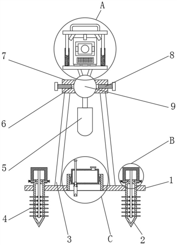
  • Topographic surveying and mapping device with marking function
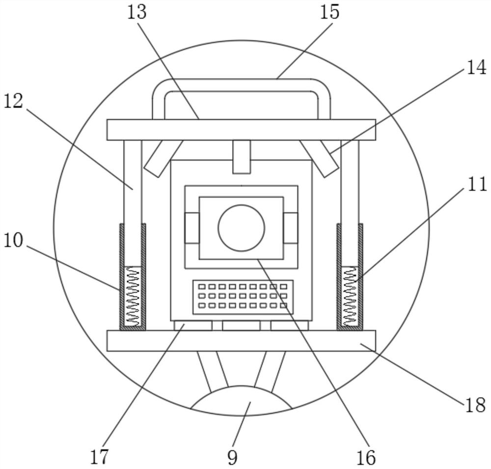
  • Topographic surveying and mapping device with marking function
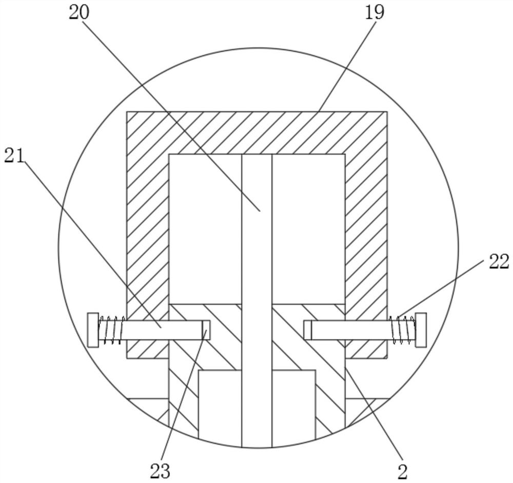
  • Topographic surveying and mapping device with marking function

Examples


Embodiment 1

[0031] refer to Figure 1-5 , a topographic surveying device with a marking function, comprising a base plate 1, a support rod 3 is arranged on the top outer wall of the base plate 1, and a fixed seat 7 is fixedly connected to the top of the support rod 3, and a universal ball is arranged on the inner rotation of the fixed seat 7 9, and the outer wall of the bottom of the universal ball 9 is connected with the counterweight 5 through the connecting rod, the outer walls of both sides of the fixed seat 7 are provided with threaded holes 6, and the inner walls of the threaded holes are threaded with fixed bolts 8, and the universal ball 9 The top outer wall of the top is provided with a placement plate 18, and the top outer wall of the placement plate 18 is provided with a surveying instrument 16, the four corners of the top outer wall of the placement plate 18 are provided with sleeves 10, and the bottom inner wall of the sleeve 10 is provided with a first Spring 11, the top of ...

Embodiment 2

[0041] refer to Figure 6 , a topographic surveying device with a marking function. Compared with Embodiment 1, this embodiment further includes a bubble level 31 arranged on the top outer wall of the top plate 13 .

[0042] Working principle: During the surveying and mapping process, the status of the bubble level 31 can be observed in real time to ensure that the surveying instrument 16 is always in a horizontal state during the surveying and mapping, and the use effect is better.


PUM


Abstract

The invention discloses a topographic surveying and mapping device with a marking function. The device comprises a bottom plate, a supporting rod is arranged on the outer wall of the top of the bottomplate, a fixing base is fixedly connected to the top end of the supporting rod, a universal ball is rotatably arranged in the fixing base, and a balancing weight is connected to the outer wall of thebottom of the universal ball through a connecting rod; threaded holes are formed in the outer walls of the two sides of the fixing base, the inner walls of the threaded holes are in threaded connection with fixing bolts, a containing plate is arranged on the outer wall of the top of the universal ball, a surveying instrument is arranged on the outer wall of the top of the containing plate, sleeves are arranged at the four corners of the outer wall of the top of the containing plate, and first springs are arranged on the inner walls of the bottoms of the sleeves. A telescopic rod is arranged at the top end of each first spring. The device can fix surveying and mapping instruments of different sizes, horizontal calibration is very simple, the using effect is better, the device is convenientto disassemble and assemble, and meanwhile the stability of the device in the using process is guaranteed.

Description

technical field [0001] The invention relates to the technical field of terrain surveying and mapping, in particular to a terrain surveying and mapping device with a marking function. Background technique [0002] Topographic surveying and mapping is the measurement and mapping of terrain, based on computer technology, photoelectric technology, network communication technology, space science, and information science, with global navigation satellite positioning system, remote sensing, and geographic information system as the technical core. Feature points and boundaries obtain graphics and position information reflecting the current situation of the ground through measurement means, which are used for planning, design and administrative management of engineering construction. [0003] At present, there are still some deficiencies in the existing topographic surveying and mapping devices. Usually, the device and the surveying instrument are an integrated structure and cannot b...

Claims


Application Information

Patent Timeline
Patent Type & Authority Applications(China)
IPC IPC(8): G01C15/00G01C15/02G01C9/24
CPCG01C15/00G01C15/02G01C9/24
Inventor 孙亚飞张娟娟张志敏丁磊香侯绍洋
Owner HENAN UNIV OF URBAN CONSTR
Learn More